AREOGRAPHY:
MAPPING BARSOOM
In the first volume of what would eventually become
a 11-book series, Edgar Rice Burroughs states that John Carter was first
transported to the planet Mars on March 3, 1866. He spent the next nine
years on Marscalled Barsoom by the Martians. After returning to Earth
precipitously, he sought for ten years a way to return to Barsoom and his
beloved Dejah Thoris. He eventually died on a bluff on the Hudson River
in New York on March 4, 1886and returned to Mars. His manuscripttitled
A
Princess of Mars -- was published by Burroughs in 1912.
Describing Dejah Thoris drawing of a map of Barsoom,
the reference to long straight lines, sometimes running parallel and sometimes
converging toward some great circle indicates that the map referenced
by Burroughs for his Barsoomian aerography is Giovanni Schiaparellis final
map of Mars, compiled from his observations during oppositions of the red
planet from 1877-1886. Schiaparelli was the first and primary astronomer
to record parallel "canalli" on Mars:
Taking a great diamond
from her hair [Dejah Thoris] drew upon the marble floor the first map of
Barsoomian territory I had ever seen. It was crisscrossed in every direction
with long straight lines, sometimes running parallel and sometimes converging
toward some great circle. The lines, she said, were waterways; the circles,
cities; and one far to the northwest of us she pointed out as Helium.
(Princess of Mars, Chap. 16, p. 80)
Waterways go to Helium from the southeast. One passes 50
miles south of Thark, another passes 200 miles north of Thark. There is
another unnamed waterway north of Thark moving roughly east-west but probably
to the unnamed city east of Helium.
Roughly northwest of Helium is a large unnamed city with
smaller cities between. Hastor is about 185 mi. due south of Greater Helium,
and Zor lies about 380 miles southeast of Helium. We have little to no
information on the north and south-west areas.
Ruins of Barsooms ancient dead cities may be found at
the original edges of former seacoasts, with successive re-settlements
following the retreating seas out into the deserts, where their last remnants
lie at the intersections of canals:
Upon the edges of plateaus
that once had marked the shore-line of a noble continent I passed above
the lonely monuments of that ancient prosperity, the sad, deserted cities
of old Barsoom. Even in their ruins there is a grandeur and magnificence
that still have power to awe a modern man. Down towards the lowest sea
bottoms other ruins mark the tragic trail that that ancient civilization
had followed in pursuit of the receding waters of its ocean to where the
last city finally succumbed, bereft of commerce, shorn of power, to fall
at last an easy victim to the marauding hordes of fierce, green tribesmen,
whose descendants now are the sole rulers of many of those deserted sea
bottoms. (Fighting Man, chap. 2, p.
164)
Regarding translating terms:
In several footnotes, Burroughs states that he
has translated Barsoomian terms into their English equivalents. This is
a crucial clue to the first step in unraveling the cartographic puzzle
Burroughs imbeds throughout the series as to the locations of Barsoomian
cities and other features:
I have used the word
radium in describing this powder because in the light of recent discoveries
on Earth I believe it to be a mixture of which radium is the base. In Captain
Carters manuscript it is mentioned always by the name used in the written
language of Helium and is spelled in hieroglyphics which it would be difficult
and useless to reproduce. (Princess of
Mars, chap. 13, p. 60: footnote)
Wherever Captain Carter has used
Martian measurements of time, distance, weight, and the like I have translated
them into as nearly their equivalent in Earthly values as possible.
(Gods of Mars, chap. 17, p. 144: footnote)
Magnetic Field:
Several times in the Chronicles, reference is made to
the Magnetic field of Barsoom:
It was this type of motor
with which my scout flier was equippeda seemingly fuelless motor, since
it derived its invisible and imponderable energy from the inexhaustible
and illimitable magnetic field of the planet.
(Fighting Man, chap. 2, p. 163)
I afterward learned that the shaft
rests directly over the magnetic pole of Mars, but whether this adds in
any way to its incalculable power of attraction I do not know.
(Warlord, chap. 5, p. 277)
Unfortunately for these narratives, Mars has virtually no
magnetic field whatsoever, and thus no magnetic pole. This lack of a magnetic
field also means Mars has no radiation belt like the Earth's Van Allen
Belts, nor any polar auroras. This, however, was not known in Burroughs'
time, but was only discovered by the Viking missions in the early 1970s.
Ancient History:
A million years ago, shallow oceans covered much of the
planet, and a great seafaring civilization of white-skinned, yellow-haired
people called the Orovars ruled the world and plied the seas in great ships.
Three of the novels (PM, FMM, LG) provide specific referencess:
It is sad, Sola, that
you were not born a million years ago, snapped Sarkoja, when all the
hollows of the land were filled with water, and the peoples were as soft
as the stuff they sailed upon. (Princess of Mars, chap. 9, p. 39)
[Dejah Thoris] told me that these
people had presumably flourished over a hundred thousand years ago. [an
apparent contradiction!] They were the early progenitors of her race, but
had mixed with the other great race of early Martians, who were very dark,
almost black, and also with the reddish yellow race which had flourished
at the same time.
These three great divisions of the
higher Martians had been forced into a mighty alliance as the drying up
of the Martian seas had compelled them to seek the comparatively few and
always diminishing fertile areas, and to defend themselves, under new conditions
of life, against the wild hordes of green men.
Ages of close relationship and intermarrying
had resulted in the race of red men, of which Dejah Thoris was a fair and
beautiful daughter. (Princess of Mars, chap. 11, p. 52)
[Hadron in Xanator] From the upper
floor a wooden ladder extended upward through the centre of the tower above.
It was of solid skeel, which is practically indestructible, so that though
I knew it might be anywhere from five hundred thousand to a million years
old, I did not hesitate to trust myself to it. (Fighting Man, chap.
3, p. 34)
I do not know how old these buildings
are [in Horz] but I have heard Martian savants argue that the original
dominant race of white-skinned, yellow-haired people flourished fully a
million years ago. (Llana of Gathol, book 1, chap. 3, p. 14)
The inhabitants of Horz are, as
far as we know, the sole remaining remnant of the once dominant race of
Barsoom, the Orovars. A million years ago our ships ranged the five great
oceans, which we ruled. The city of Horz was not only the capital of a
great empire, it was the seat of learning and culture of the most glorious
race of human beings a world has ever known. Our empire spread from pole
to pole. There were other races on Barsoom, but they were few in numbers
and negligible in importance. We looked upon them as inferior creatures.
The Orovars owned Barsoom, which was divided among a score of powerful
jeddaks. They were a happy, prosperous, contented people, the various nations,
seldom warring upon one another. Horz had enjoyed a thousand years of peace.
They had reached the ultimate pinnacle
of civilization and perfection when the first shadow of impending fate
darkened their horizonthe seas began to recede, the atmosphere to grow
more tenuous. What science had long predicted was coming to passa world
was dying.
For ages our cities followed the
receding waters. Straits and bays, canals and lakes dried up. Prosperous
seaports became deserted inland cities. Famine came. Hungry hordes made
war upon the more fortunate. The growing hordes of green men overran what
had once been fertile farm land, preying upon all. (Llana, book
1, chap. 4, pp. 16-17)
Then why are the pits here? [in
Horz] I demanded.
Oh,
they were built when the city was built, perhaps a million years ago, perhaps
more. (Llana, book 1, chap. 5, p. 20)
and six other references mentioning the time of the Orovars
as a million years ago.
Creation Myth:
All the peoples of Barsoom (except the Phundahlians)
claim descent from the legendary Tree of Life, said to have flourished
in the Valley Dor at the South Pole 23 million years ago:
The First Born of Barsoom,
[Xodar] explained, are the race of black men of which I am a Dator, or
as the lesser Barsoomians would say, Prince. My race is the oldest on this
planet. We trace our lineage, unbroken, direct to the Tree of Life which
flourished in the Valley Dor twenty-three million years ago.
For countless ages the fruit of
this tree underwent the gradual changes of evolution, passing by degrees
from true plant to a combination of plant and animal. In the first stages
the fruit of the tree possessed only the power of independent muscular
action, while the stem remained attached to the parent plant; later a brain
developed in the fruit, so that hanging there by their long stems they
thought and moved as individuals.
Then, with the development of perceptions
came a comparison of them, and thus reason and the power to reason were
born upon Barsoom.
Many forms of life came and went
upon the tree with the passing ages, but still all were attached to the
parent plant by stems. At length the fruit of the tree consisted in tiny
plant men, such as we now see reproduced in such huge dimensions in the
Valley Dor, but still hanging to the limbs and branches of the tree by
the stems which grew from the tops of their heads.
The buds from which the plant men
blossomed reassembled large nuts about a foot in diameter, divided by double
partition walls into four sections. In one section grew the plant man,
in another a sixteen-legged worm, in the third the progenitor of the white
ape and in the fourth the primeval black man of Barsoom.
When the bud burst the plant man
remained dangling at the end of his stem, but the three other sections
fell to the ground, where the efforts of their imprisoned occupants to
escape sent them hopping about in all directions.
Thus, as time went on, all Barsoom
was covered with these imprisoned creatures. For countless ages, they lived
their long lives within their hard shells, hopping and skipping about the
broad planet; falling into rivers, lakes, and seas, to be still further
spread about the surface of the new world.
Countless billions died before
the first black man broke through his prison walls into the light of day.
Prompted by curiosity, he broke open other shells and the peopling of Barsoom
commenced.
The pure strain of the blood of
this first black man has remained untainted by admixture with other creatures
in the race of which I am a member; but from the 16-legged worm, the first
ape and renegade black man has sprung every other form of animal life upon
Barsoom (Gods of Mars, chap. 7, pp. 62-63)
[Ras Thavas] Now, on Mars, we hold
to a very different theory of creation and evolution. We believe that as
the planet cooled chemicals combined to form a spore which was the basis
of vegetable life from which, after countless ages, the Tree of Life grew
and flourished, perhaps in the center of the Valley Dor twenty-three million
years ago, as some believe, perhaps elsewhere... [continues word-for-word
as previous.] (Synthetic Men, chap. 7, p. 223)
[Man Lat] Do you not know that
the First Born of Barsoom, sometimes known to you lesser creatures as The
Black Pirates of Barsoom, are of the oldest race on the planet. We trace
our lineage, unbroken, direct to the Tree of Life which flourished in the
Valley Dor twenty-three million years ago... [continues word-for-word
as previous.] (Llana, book 2, chap. 12, pp. 90-91)
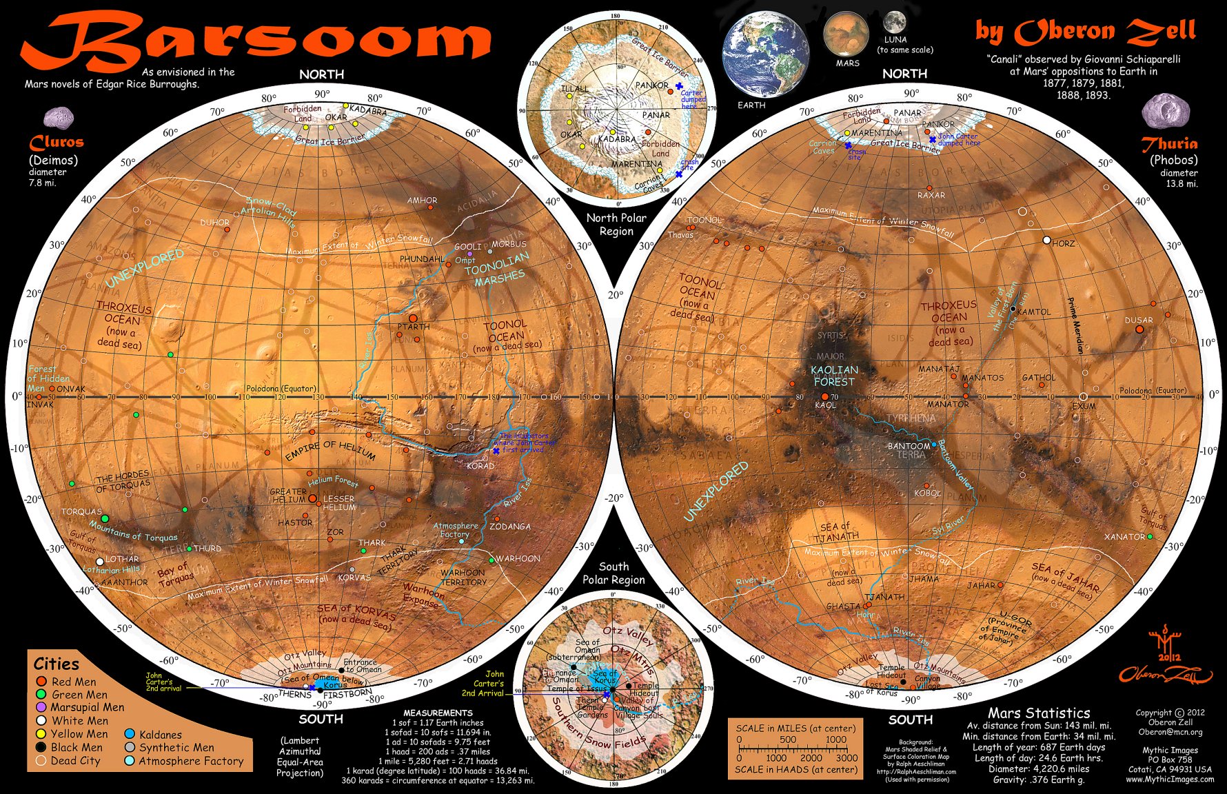
A
BARSOOMIAN GAZETTEER
Here follows a Gazetteer of Barsoom, along with
quotations I have carefully gleaned from the Chronicles that provide
the clues to all the locations cited. For much of this information, I am
greatly indebted to J.G. Huckenpöhlers excellent Hucks Gazetteer
of Barsoom; and to John Flint Roy's A Guide to Barsoom
(Ballantine Books, NY, 1976):
AAANTHOR - Dead
city in the no-man's land between Torquas and Thurd. Now inhabited only
by white apes and occasional roving bands of green men. Located at 50o
S., and 40o E. of Horz, and about 65 miles southeast of the
boundary of Torquas. (TMM/4, 12)
Thar Ban, Jed among the hordes of
Torquas, rode swiftly across the ocre vegetation of the dead sea-bottom
toward then ruins of ancient Aaanthor. (Thuvia,
chap. 4, p. 30)
From the boundary of Torquas to
the city of Aanthor is a distance of some 200 haads (74 mi.), so that the
Heliumite had before him a journey of more than 150 Earth miles between
him and Aanthor [through a tunnel from Lothardaylight hours]
coming at
last into the light of day beyond the mountains, and no great distance
from the southern verge of the domains of the Torquassians, not more than
150 haads (55 mi.) at most. (Thuvia, chap.
10, p. 83)
Aanthor lies in 50° south latitude
and 40° east of Horz
while Dusar lies 15° north of the equator
and 20° east from Horz. (Thuvia, chap.
12, p. 102)
[from Aanthor] All that night and
the following day and the second night they rode toward the northeast
and
at dawn of the second day Carthoris saw in the distance the waving ribbon
of great trees that marked one of the long Barsoomian waterways. [Thoats
can travel 80 miles per day, so this 30-hour thoat ride may have covered
120 miles.]
It was mid-forenoon when
the two at last entered one of the roads that cut through the cultivated
districts at regular intervals, joining the arid wastes on either side
with the great white, central highway that follows through the center from
end to end of the far-reaching, threadlike farm lands. (Thuvia,
chap. 11, p. 98)
AMHOR City-state of red men, in Schiaparellis
Jacartes, 740 mi. north of the Toonolian Marshes, 1,850 mi. east of Duhor,
700 miles north of Morbus, and about 660 mi. north of a point about
115 mi. west of Gooli. The principal business is raising thoats and zitidars.
Amhor is noted for its comprehensive zoo, which even exhibits humans and
green men. Amhorians are hereditary enemy of Duhorians. (MMM/4; SMM/23-27)
5,000 haads (1,850 mi.) separate
Duhor from Amhor. (Mastermind, chap. 4, p. 396)
Amhora city about 700 miles north
of Morbus. (Synthetic Men, chap. 4, p. 208)
Amhor lies about 750 Earth miles
directly north of the point where our capture took place, which distance
the ship covered in about seven and a half hours [at 60 mph]. (Synthetic
Men, chap. 23, p. 311)
ARTOLIAN HILLS Extensive range of snow-clad hills
surrounding Duhor and extending towards Toonal. They lie between 740-1100
mi. north of Ptarth and the same distance west of Phundahl. Schiaparellis
Tanais.
(MMM/4; SMM/2)
Duhor lies a full 7,800 haads (2,886
mi.) from Toonol, upon the opposite side of the snow-clad Artolian Hills.
(Mastermind, chap. 4, p. 397)
The snow-clad Artolian Hills which
surround Duhor
(Synthetic Men, chap. 2, p. 199)
ATMOSPHERE FACTORY - Installation regulating the
Martian atmosphere, which is largely artificial. Located to the northwest
of Warhoon, between Thark and Warhoon territory, near their northern boundaries,
about 825 mi. (10 days by thoat) from Zodanga, near a Zodangan canal. (PM/20;
WM/9)
[From Warhoon] I started off in
a northwesterly direction towards a point where
lay the nearest waterway
Through two long weeks I wandered
At daybreak of the fifteenth day of
my search I was overjoyed to see the high trees that denoted the object
of my search. About noon I dragged myself wearily to the portals of a huge
building [the Atmosphere Factory] which covered four square miles and towered
two hundred feet in the air. (Princess, chap. 20, pp. 97-98)
BANTOOM - Valley and kingdom in the southern hemisphere
inhabited by the bizarre Kaldanes, about 1,320 mi. southwest of Torquas,
and 3,630 mi. west-southwest of Helium and far southwest of Gathol. Mare
Tyrrhenum. Unusually, a small stream runs through the valley, which
runs from northwest to southeast. (CM/3-9)
Beneath her spread a beautiful valley
surrounded by low hills. Dotting it were numerous circular towers, dome-capped,
and surrounding each tower was a stone wall enclosing several acres of
ground. The valley appeared to be in a high state of cultivation. (Chessmen,
chap. 3, p. 159)
Then her eyes wandered out across
the valley until presently they picked out what appeared to be a tiny stream
winding its way through the center of the farm landsa strange sight upon
Barsoom. (Chessmen, chap. 3, p. 161)
CARRION CAVES - Series of 27 interconnected caverns
(a former underground riverbed) snaking through the edge of the Arctic
icecap, about one-sixth of the way around the planet from Kaol. They are
the only land passage connecting the hothouse cities of the North Pole
with the outside world, beneath the ice cliffs. Here the yellow men of
Okar bring their dead so that the stench will discourage any invasion of
their territory. (WM/8)
[From Kaol] Straight toward the
north, Day and night, our destination compass led us after the fleeing
flier
Early in the second night
we noticed the air becoming perceptibly colder, and from the distance we
had come from the equator were assured that we were rapidly approaching
the north arctic region.
never
had any flier returned who had passed to any considerable distance beyond
the mighty ice-barrier that fringes the southern hem of the frigid zone
The distance from the barrier to the pole was no more than a swift flier
should cover in a few hours [at about 75 mph]
(Warlord,
chap. 8, p. 263)
Suddenly a towering wall of white
rose directly in our path, and
with a sickening crash we struck the high
looming obstacle three-quarters on.
we found we were at the foot of a
mighty ice-barrier, from which outcropped great patches of the granite
hills which hold it from encroaching farther toward the south
.
Nor shall I admit that it [the ice barrier] is impassable before I have
followed its entire circle and stand again upon this spot, defeated. The
sooner we start, the better, for I see no other way, and it will take us
more than a month to travel the weary, frigid miles that lie before us.
For five days of cold and suffering and privation we traversed the rough
and frozen way which lies at the foot of the ice-barrier. (Warlord,
chap. 8, p. 264)
for the better part of two hours
the trail paralleled the barrier, and then suddenly turned toward it through
the roughest and seemingly most impassable country I ever had beheld
For another two hours we were occupied in traversing a few hundred yards
to the foot of the barrier.
Then, turning about the corner of a wall-like outcropping of granite, we
came upon a smooth area of two or three acres before the base of the towering
pile of ice and rock that had baffled us for days, and before us beheld
the dark and cavernous mouth of a cave
the fabled Carrion Caves! (Warlord,
chap. 8, p. 266)
DUHOR City-state of red men. Located 1,850 mi.
west of Amhor, 2,886 mi. from Toonol, on the opposite side of the Artolian
hills. North and a little west of Ptarth, and 3,465 mi. northweast (or
northeast) of Helium, at the intersection of Schiaparellis Sirenius
and Tanais. Duhor and Amhor are hereditary enemies. (MMM/4, 6, 14;
FMM/Foreword; SMM/1, 2)
When the ship, with its small convoy,
had covered 4,000 of the 5,000 haads (1,850 mi.) that separate Duhor from
Amhor, it was sighted by a fleet from Phundahl which immediately attacked.
(Master Mind, chap. 4, p. 396)
Duhor lies a full 7,800 haads (2,886
mi.) from Toonol, upon the opposite side of the snow-clad Artolian Hills.
You, a stranger and alone, could never reach it; for between lie the Toonolian
Marshes, wild hordes, savage beasts and warlike cities. You would die uselessly
within the first dozen haads, even could you escape the island upon which
stands the laboratory of Ras Thavas. (Master Mind, chap.
4, p. 397)
Ptarth lay at a considerable distance
to the west of Phundahl, and a little south and about an equal distance
from Duhor, which lay north and a little west of it. An inhabitant of Ptarth
would
know much of the entire country included in the triangle formed by Phundahl,
Ptarth and Duhor. (Master Mind, chap. 6, p. 410)
Duhor lies
about 4,000 Earth miles
northwest [northeast] of the twin cities of Helium. (Synthetic
Men, chap. 2, p. 197)
DUSAR - Powerful nation of red men, noted for its
honey. Its capital, of the same name, is situated 4,455 mi. west of Ptarth,
at 15o N., 20o E. of Horz. Its domain stretches far to the south; one of
its canals (Schiaparelli's Tartarus) passes to the northeast of
Torquas. In
Trivium Charontis. TMM/-; FMM/16; LG-4/1)
[From Dusar] 13,500 haads (4,995
mi.) away lay Ptarth-- a stiff thirty-hr. journey [@ 148 mph] for the swiftest
of fliers. (Thuvia, chap. 14, p. 122)
[From Horz] Far ahead lay Dusar
Beyond Dusar was no friendly city all the way to Helium. (Llana,
book 4, chap. 1, p. 152)
EXUM - Dead city on the equator, identified as
Barsoomian Greenwich. A line drawn between Lesser Helium and Horz (also
on the Prime Meridian at a distance of 5,000 miles from Helium) bisects
the equator about 1,600 miles east of the prime meridian. I place Exum
at 220°W on a modern map of Mars, where Schiaparellis Cerberus and
Antaeus Funostos canals cross. (SMM/2; LG-1/1)
I flew northwest from Helium, which
lies 30 degrees south of the Equator which I crossed about 1,600 miles
east of Exum, the Barsoomian Greenwich. North and west of me lay a vast,
almost unexplored region
(Llana, chap. 1, p. 6)
FORBIDDEN LAND - What the outer world Barsoomians
call the arctic region within the great northern Ice Barrier. (WM/8)
The distance from the barrier to
the pole was no more than a swift flyer should cover in a few hours, and
so it was assumed that some frightful catastrophe awaited those who reached
the forbidden land, as it had come to be called by the Martians of the
outer world. (Warlord, chap. 8, p. 140)
FOREST OF HIDDEN (or LOST) MEN A sunken, fertile
valley (Shiaparelli's
Nodus Gordii) on the equator between Exum
and Helium, and south of a line between Helium and Dusar, between 40°-50°E
of Exum. Two rival cities of Invak (on the equator at the western side
of the Forest) and Onvak (to the east) are at constant war with each other.
The people ingest pills that render them invisible for a time. (LG-4/1-)
We decided to give Dusar a wide
berth, and in doing so we flew over country with which I was entirely unfamiliar.
It was a hilly country, and in the long deep valley I saw one of those
rarest of all sights on Mars, a splendid forest. (Llana,
book 4, chap. 1, p. 152)
GATHOL - Gathol is the oldest Red Martian inhabited
city on Barsoom, noted for its inexhaustible diamond mines. The kingdom
of Gathol extends from the equator to 10o N., and from 10o-20o
W of Exum. Schiaparellis Aethiops canal marks the western boundary of
the country. The city was built upon an island in the Throxeus Ocean, and
now covers a mountain entirely surrounded by a great salt marsh. The country
consists of the mountain city, with its diamond mines, and a great area
of grazing land for thoats and zitidars. (CM/-; FMM/1; LG/-)
My country [Gathol] extends from
Polodona [the equator] north ten karads [degrees] and from the 10th karad
west of Horz to the 20th west, including thus a million square haads, the
greater portion of which is fine grazing land where run our great herds
of thoats and zitidars. (Chessmen, chap. 1, p. 142)
Gathol
is very much more than just
a single city, comprising, as it does, some 140,000 square miles, much
of which is fine grazing land where run their great herds of thoats and
zitidars. (Llana, book 3, chap. 1, p. 99)
The far northwest of the country
is cut by one of Barsoom's famous canals [Schiaparelli's
Aethiops.
OZ]; and here the grains, and vegetables,
and fruits which supply the city are raised; while upon her plains graze
the herds that supply her with meat. (Llana, book 31, chap.
4, p. 108)
Your ancient history has doubtless
told you that Gathol was built upon an island in Throxeus, mightiest of
the five oceans of old Barsoom. As the ocean receded Gathol crept down
the sides of the mountain, the summit of which was the island upon which
she had been built, until today she covers the slope from summit to base,
while the bowels of the great hill are honeycombed with the galleries of
her mines. Entirely surrounding us is a great salt marsh, which protects
us from invasion by land, while the rugged and oft-times vertical topography
of our mountain renders the landing of hostile airships a precarious undertaking.
(Chessmen, chap. 1, p. 142)
It is only about 4,000 haads (1,480
mi.) from Horz to Gathol. (Llana, book 1, chap. 7, p. 27)
Gathol is southwest of Horz
(Llana, book 2, chap. 1, p. 52)
GHASTA - A small walled citadel of red men, inside
the crater of an extinct volcano called the Valley Hohr, through which
runs the River Syl from Tjanath. The population is only 100 members of
the court and 500 slaves. It is southwest of Tjanath, perhaps 15 mi. inside
the border. (FMM/78-9)
[Coming down the underground river
southwest from Tjanath] Presently we saw ahead of us what appeared to be
an opening in the forest, and a moment later we emerged into a clearing.
Looming in from of us at a distance of perhaps less than a haad (.37 mi.)
was a towering pile of masonry. It was a gloomy pile, apparently built
of black volcanic rock. For some thirty feet above the ground there was
a blank wall, pierced by but a single openinga small doorway almost directly
in front of us. This part of the structure appeared to be a wall, beyond
it rose buildings of weird and grotesque outlines, and dominating all was
a lofty tower, from the summit of which a wisp of smoke curled upward into
the quiet air.
(Fighting Man, chap. 7, p. 230)
GOLDEN CLIFFS - The 5,000-foot sheer walls of a
possible impact crater within the Otz Mountains, surrounding the Lost Sea
of Korus and the Valley Dor at the south pole. They are honeycombed with
deep caverns and shot with veins and patches of solid gold, broken by outcroppings
of ruby, emerald, and diamond boulders. GM/1; WM 1)
At a little distance up the river
rose mighty perpendicular bluffs, from the very base of which the great
river seemed to rise. (Gods, chap. 1, p. 4)
The cliffs rose perpendicular directly
from the almost level sward of the valley. There was no accumulation of
fallen debris, forming a more or less rough ascent to them, as is the case
with nearly all other cliffs I have ever seen. The scattered boulders that
had fallen from above and lay upon or partly buried in the turf, were the
only indication that any disintegration of the massive, towering pile of
rocks ever had taken place
To my
right the bottom of the cliff was lost in the dense foliage of the forest,
which terminated at its very foot, rearing its gorgeous foliage fully a
thousand feet against its stern and forbidding neighbor.
To the
left the cliff ran, apparently unbroken, across the head of the broad valley,
to be lost in the outlines of what appeared to be a range of mighty mountains
that skirted and confined the valley in every direction.
Perhaps
a thousand feet from me the river broke, as it seemed, directly from the
base of the cliffs
The cliffs
towered above me a good 5,000 feet. The sun was not quite upon them and
they loomed a dull yellow in their own shade. Here and there they were
broken with streaks and patches of dusky, red, green, and occasional areas
of white quartz. (Gods, chap. 2, p. 11)
When the sun passed the cliffs
zenith, and as the bright rays touched the dull surface it burst out into
a million scintillant lights of burnished gold, of flaming red, of soft
greens, and gleaming whitesa more gorgeous and inspiring spectacle human
eye has never rested upon.
The face of the entire cliff was
so shot with veins and patches of solid
gold as to quite present the appearance of a solid wall of that precious
metal except where it was broken by outcroppings of ruby, emerald, and
diamond boulders. (Gods, chap. 2, p. 12)
GOOLI - A village of thatched grass huts on the
island of Ompt in the Toonolian Marshes, inhabited by a vain, idiotic and
cowardly race of kangaroo-like oviparous marsupial humanoids. (SMM/20-22)
They led us back along the stream
and up over a little rise of ground before which we saw a forest, at the
edge of which lay a village of thatched huts.
That, said the leader, pointing, is Gooli, the largest city in the world.
There, in his great palace, dwells Anatok, Jed of Gooli and all of the
Island of Ompt. (Synthetic Men, chap. 20, p. 298)
GREAT ICE BARRIER A towering wall of ice completely
surrounding the north polar region at about 70°-77°N. (WM/8)
The distance from the barrier to
the pole was no more than a swift flyer should cover in a few hours
(Warlord, chap. 8, p. 140)
Suddenly a towering wall of white
rose directly in our path, and though I threw the helm hard over, and reversed
our engine, I was too late to avoid collision.
we found
we were at the foot of a mighty ice-barrier, from which outcropped great
patches of the granite hills which hold it from encroaching farther toward
the south.
(Warlord, chap. 8, p. 140-141)
Nor shall I admit that it
[the ice barrier] is impassable before I have followed its entire circle
and stand again upon this spot, defeated. The sooner we start, the better,
for I see no other way, and it will take us more than a month to travel
the weary, frigid miles that lie before us.
For five
days of cold and suffering and privation we traversed the rough and frozen
way which lies at the foot of the ice-barrier. (Warlord,
chap. 8, p. 142)
HASTOR - City subject to Helium, about 185 mi.
due south of Greater Helium. It is noted for its airship building. Located
near the southern border of the Empire of Helium, it serves as a bastion
against the savage green Thurds. (GM/18-20; WM/6; FMM/1; SMM/25; LG-3/7)
[Hastor]
lies directly south
of Greater Helium, sir; about 500 haads. (185 mi.) (Llana,
book 3, chap. 7, p. 121)
HELIUM FOREST - Wooded area in the Valley of Helium,
northwest of the Twin Cities. Its huge sorapus trees furnish much of the
lumber supply to the civilized nations of Mars.
[Sola:] We might hide among the
great trees [of the Helium Forest] for a time, but the chances are small
indeed for escape. (Princess, chap. 16, p. 80)
HELIUM Mighty empire of red men, in the southeastern
quadrant. Principal exports are lumber and metal products. Its boundaries
extend from the southern ice fields to and beyond the equator; and from
Torquas in the west to the boundaries of Zodanga in the east. It has the
greatest air navy on Barsoom. Its central capital consists of two immense,
circular walled cities, 75 miles apart: Greater Helium and Lesser Helium.
(All books)
Helium
alone of all Barsoomian
metropolises consists in two immense circular walled cities about 75 miles
apart. (Princess, chap. 23, p. 124)
In the middle of the afternoon we
sighted the scarlet and yellow towers of Helium, and a short time later
a great fleet of Zodangan battleships rose from the camps of the beseigers
without the city, and advanced to meet us.... (Princess,
chap. 26, p. 135)
The three great powers of the eastern
hemisphereHelium, Ptarth and Kaol. (Thuvia, Chap. 10, p.
83)
HELIUM, GREATER - Capital of the Empire of Heium,
famous for its mile-high Scarlet Tower, is at 30o S., and 1,000
mi. southwest of Zodanga (Princess of Mars). Or, alternately, 1,900
miles due west of Zodanga (Swords of Mars)
Helium lies a thousand miles southwest
of Zodanga, and with my compass intact I should have made the trip
in four
or five hours. (Princess, chap. 23, p.124)
Over 1,900 miles east of the Twin
Cities of Helium, at about 30o south, longitude 172o east, lies Zodanga.
(Swords,
chap. 1, p. 5)
HELIUM, LESSER - Second city of the Empire of Helium,
it lies 66 mi. northwest of Greater Helium, and about 5,000 miles southeast
of Horz. Its major landmark is a mile-high yellow tower.
I flew northwest from [Lesser] Helium,
which lies 30 degrees south of the Equator
(Llana, chap.
1, p. 6)
HELIUM, VALLEY OF Forested valley lying between
Greater Helium and Lesser Helium, and stretching away to the northwest.
Solis
Lacus.
[In Thark] The great waterway which
leads to Helium is but fifty miles to the south, murmured Sola, half to
herself; a swift thoat might make it in three hours; and then to Helium
it is 500 miles, most of the way through thinly settled districts
Finally,
after studying the map carefully in the moonlight which now flooded the
room, I pointed out a waterway far to the north of us which also seemed
to lead to Helium.
Does
not this pierce your grandfathers territory? I asked.
Yes,
she answered, but it is 200 miles north of us; it is one of the waterways
we crossed on the trip to Thark. (Princess, chap. 16, p.
80)
HOHR VALLEY- The gigantic crater of a long-extinct
volcano, cut by the River Syl, one days walk (in the dark, probably less
than 30 mi.) southwest of Tjanath. In the crater is located the horrible
citadel of Ghasta. (FMM/7)
From this new vantage-point we had
a better view of the valley than had at first been accorded us, and now
more marked than ever were the indications that it was the crater of some
gigantic and long-extinct volcano. (Fighting Man, chap. 7,
p. 230)
HOLY LAND What the First Born, or Black Pirates,
call the secret subterranean world beneath the Valley Dor, at the south
pole, where their Temple of Issus is located. (GM/8)
You will see what no other than
the First Born and their slaves know the existence ofthe subterranean
entrance to the Holy Land, to the real heaven of Barsoom. (Gods,
chap. 8, p. 69)
HORZ - An ancient city, seat of Barsoomian culture
and learning, and last refuge of the white race of Orovars, a million years
ago. On the central meridian (220°), 1,320 mi. north-northeast of Gathol,
and 5,000 miles northwest of Lesser Helium. (TMM/12; LG-1/-; LG-2/1; LG-4/1)
I had set my directional compass
upon Horz, the long deserted city of ancient Barsoomian culture, and loafed
along at 75 miles an hour at an altitude of 500 to 1,000 feet. I had seen
some green men northeast of Torquas and had been forced up to escape their
fire, which I did not return as I was not seeking adventure; and I had
crossed two thin ribbons of red Martian farm land bordering canals that
bring the precious waters from the annually melting ice caps at the poles.
Beyond these I saw no signs of human life in all the 5,000 miles that lie
between Lesser Helium and Horz. (Llana, Chap. 1, p. 6)
It was about noon of the third day
when I sighted the towers of ancient Horz. The oldest part of the city
lies upon the edge of a vast plateau; the newer portions, and they are
countless thousands of years old, are terraced downward into a great gulf,
marking the hopeless pursuit of the receding sea upon the shores of which
this rich and powerful city once stood
.
Horz is,
perhaps, the oldest and the greatest of the dead cities of Barsoom.
(Llana, chap. 1, p. 7)
It is fully 4,000 haads from here
[Horz] to Gathol, the nearest friendly city. That would be the equivalent
of 1,500 milesa very long walk. [Actually, 4,000 haads = 1,480
mi. -OZ] (Llana, chap. 13, p. 49)
ILLALL - Okar city in the Arctic icecap, the most
remote from the capital of Kadabra. (WM/9)
We be from Illall, I continued,
giving the name of the most remote city of Okar, which has little or no
intercourse with Kadabra. (Warlord, chap. 5, p. 277)
INVAK - City of red men in the Forest of Lost (or
Hidden) Men between Horz and Helium, south of Dusar, on the Equator, some
1850 miles east of Gathol. The inhabitants have invented a pill which renders
them invisible for about a day. Since John Carter reached Invak first,
it must be the further west of the two cities in the valley. The
other city is Onvak, bitter enemies to Invak. (LG-4/-)
Resistance will be futile, said
the voice; there are twenty of us and only one of you
I am Ptantus, jeddak
of Invak. (Llana, book 4, chap. 2, p. 153)
I was trying out a new motor that
we have developed in Zodanga and was trying to establish a record for a
circumnavigation of Barsoom at the Equator, and of course this place had
to be on the Equator and right under me when my motor quit. (Llana,
book 4, chap. 4, p. 162)
There is another city in the forest
inhabited by an offshoot of this tribe, explained Ptor Fak; it is called
Onvak, and its people also possess the secret of invisibility. Occasionally
the Onvaks come and attack Invak, or lie in wait for the Invak hunting
parties when they go out into the forest. (Llana,
book 4, chap. 4, p. x)
ISS, RIVER - The sacred river of the dead, also
called the River of Death and the River of Mystery. Its main source is
certainly the Great Toonolian Marshes. Much of it is underground, but there
are various access points where pilgrims may take boats for their final
journey to the Barsoomian Paradise in the Valley Dor at the south pole.
It flows southward, probably through Mare Acidalium, Niliacus
Lacus, and via the Indus to the Margaritifer Sinus, and
thence from Pandorae Fretum into Hellespontus and the southern
icecap, where it flows underground for 1,000 miles before finally entering
the Valley Dor. (PM/24; GM/-; WM/1-7)
Oh, it is the continual, awful
period of bloodshed from the time we break the shell until we gladly embrace
the bosom of the river of mystery, the dark and ancient Iss which carries
us to an unknown, but at least no more frightful and terrible existence!
(Princess, chap. 9, p 39)
All Barsoomians speak the same
tongue from the ice-clad south to the ice-clad north, though their written
languages differ. Only in the valley Dor, where the river Iss empties into
the lost sea of Korus, is there supposed to be another language spoken,
and, except in the legends of our ancestors, there is no record of a Barsoomian
returning up the river Iss, from the shores of Korus in the valley Dor.
(Princess,
chap. 11, p. 49)
To my left the sea extended as far
as the eye could reach, before me only a vague, dim line indicated its
further shore, while at my right a mighty river, broad, placid, and majestic,
flowed between scarlet banks to empty into the quiet sea before me. (Gods,
chap. 1, p. 3)
At a little distance up the river
rose mighty perpendicular bluffs, from the very base of which the great
river seemed to rise. (Gods, chap. 1, p. 4)
the subterranean passage through
which the Iss flows for a thousand miles before it enters the Valley Dor
as to reach the very walls of the Temple of Issus
(Gods,
chap. 4, p. 37)
Once we passed far above what seemed
to be a deep canyon-like rift stretching from the ice wall on the north
across the valley as far as the eye could reach. That is the bed of the
River Iss, said Xodar. It runs far beneath the ice field, and below the
level of the Valley Otz, but its canyon is open here. (Gods,
chap. 8, p. 71)
JAHAR - City and empire of red men in the southern
part of the Western Hemisphere. The capital city is about 825 mi. northeast
of Jhama. It lies southwest of 30°S, 35°E, and 50°-75°
from Torquas. Its most southern province is desolate U-Gor, overpopulated
by savage cannibals. (FMM/-)
The destination compass was of little
value to me, since I did not know the exact location of Jahar. However,
I set it roughly at a point about 30o south latitude, 35o east longitude,
as I believed that Jahar lay somewhere to the south-west of that point.
(Fighting Man, chap. 3, p. 164)
Flying at high speed I had long
since left the cultivated areas near Helium and was crossing above a desolate
and deserted waste of ocre moss that clothed the dead sea bottoms where
once rolled a mighty ocean
Upon the
edges of plateaus that once had marked the shore-line of a noble continent
I passed above
the sad, deserted cities of old Barsoom. (Fighting
Man, chap. 3, p. 164)
The city of Torquas
was once the
most magnificent and powerful of ancient Barsoom. Though it has been deserted
for ages by all but roaming tribes of green men, it is still marked on
every map, and as it lay directly in the path of my search for Jahar, and
as I had never seen it, I had purposely laid my course to pass over it
(Fighting
Man, chap. 3, p. 165)
[At Torquas] I had already flown
about 70 karads [degrees] from Helium, but I was aware that Jahar might
still be 50-70 karads distant
(Fighting Man, chap. 3, p.
166)
Jahar is northeast of Tjanath and
southwest of Xanator. (Fighting Man, chap. 5, p. 187)
JHAMA - Abandoned castle used as a laboratory by
Phor Tak, located 500 mi. northeast of Tjanath and 825 mi. west of Jahar.
(FMM/9+)
4,000 haads (1,480 mi.) of difficult
and unfriendly country lay between Jhama and Jahar. (Fighting
Man, chap. 10, p. 253)
[From Jhama] 2,500 haads (925 mi.)
to the east lay Jahar and Sanoma Tora; 1,500 haads (555 mi.) to the south-west
were Tjanath and Tavia. (Fighting Man, chap. 12, p. 264)
KADABRA Domed capital city of the Empire of Okar,
a nation of yellow men near the north pole. The citys circumference is
100 miles. A great black electromagnetic shaft directly over the north
magnetic pole outside the city attracts and destroys all aircraft venturing
close. (WM/9+)
[In Marentina] Talu gave us careful
directions for the journey to Kadabra, the capital city of the Okar nation,
which is the racial name of the yellow men
That very
evening we came within sight of the walled and glass-roofed city of Kadabra.
It lies in a low depression near the pole, surrounded by rocky, snow-clad
hills. From the pass through which we entered the valley we had a splendid
view of this great city of the north
We had
come quite close to the city when my attention was attracted toward a tall
black shaft that reared its head several hundred feet into the air
appeared to be a tangled mass of junk or wreckage, now partially snow-covered
I afterward
learned that the shaft rests directly over the magnetic pole of Mars [problem:
Mars has no magnetic field, and thus no magnetic pole. -OZ],
but whether this adds in any way to its incalculable power of attraction
I do not know. (Warlord, chap. 5, p. 277)
KAMTOL - Capital city of 200,000 in the Valley
of the First Born, a great Rift about 825 mi. west-southwest of Horz, and
northwest of Gathol. There are no clues to the location of the city within
the valley, except that it is visible from the northeastern rim of the
Rift. (LG-2/-)
You will have to come to Kamtol
with us, said the leader.
The city?
I asked. He nodded. (Llana, book 2, chap. 4, p. 61)
KAOL - City and empire of red men. Almost halfway
around the planet to the east of Helium, on the equator. One of the three
major powers of the Western Hemisphere, the country comprises a sunken
area of extreme heat and a vast tropical rain-forest (Syrtis Major).
There are several cities within the great Kaolian Forest, connected by
a network of roads. (WM/5-7, 16; TMM/10, 13-14)
we rose high above the last fortress
of the Holy Therns, and then raced straight toward the northeast and Kaol
(Warlord, chap. 5, p. 237)
All that night we raced through
the Barsoomian void, passing over low hills and dead sea bottoms; above
long-deserted cities and populous centers of Martian habitation upon the
ribbon-like lines of cultivated land which border the globe-encircling
waterways which Earth men call the canals of Mars. (Warlord,
chap. 5, p. 238)
I found that we were upon the verge
of a natural forestso rare a thing upon the bosom of dying Mars that,
outside of the forest in the Valley Dor beside the Lost Sea of Korus, I
never before had seen its like upon the planet.
From books
and travelers I had learned something of the little-known land of Kaol,
which lies along the equator almost halfway round the planet to the east
of Helium.
It comprises
a sunken area of extreme tropical heat, and is inhabited by a nation of
red men varying but little in manners, customs, and appearance from the
balance of the red men of Barsoom.
The isolation
of the Kaolians is rendered almost complete by the fact that no waterway
connects their land with that of any other nation, nor have they any need
of a waterway since the low, swampy land which comprises the entire area
of their domain self-waters their abundant tropical crops.
For great
distances in all directions rugged hills and arid stretches of dead sea
bottom discourage intercourse with them. (Warlord, chap.
5, p. 239)
The three great powers of the eastern
hemisphereHelium, Ptarth and Kaol. (Thuvia, chap. 10, p.
83)
KOBOL City-state of red men, conquered by Helium
14 years prior to the events in Fighting Man, and later sacked by
Hin Abtol on his way from Pankor to Gathol. Thus it should lie somewhere
between those two cities. However, Burroughs places it at 25°S, 45°W
(of Exum) on his rough map, so I will follow his location. (FMM/1, 16;
LG-3/4)
[Kal Tavan] I was born in
Tjanath
I turned panthan then, and sought service in other cities; thus
I served in Kobol. (Fighting Man, chap. 3, p. 161)
[Kal Tavan] For 14 years I have
served faithfully in your palace, Tor Hatan, ever since I was brought to
Helium a prisoner after the fall and sack of Kobol. (Fighting
Man, chap. 2, p. 155)
[Kal Tavan] Having been born in
Tjanath and served in Kobol, he was more familiar with this part of Barsoom
than any man in Helium. (Fighting Man, chap. 17, p. 328)
KORAD - Dead city, ancient seaport and center of
commerce and culture, now occasionally occupied by the Tharks while visiting
their northern incubator, and probably also by the Warhoons, who themselves
have an incubator just south of the city. It is some 1,450 mi. north of
the city of Thark, and well north of the northern boundary of Tharkish
territory. Korad lies to the northeast of Zodanga, and near Korad is the
point of John Carters first arrival on Barsoom. (PM/4,11-12)
We had gone perhaps ten miles [from
the incubator] when the ground began to rise very rapidly. We were nearing
the edge of one of Mars long-dead seas, in the bottom of which my encounter
with the [green] Martians had taken place.
In a short
time we gained the foot of the mountains, and after traversing a narrow
gorge came to an open valley, at the far extremity of which was a low table
land upon which I beheld an enormous city. (Princess, chap.
4, p. 16)
She said that the city in which
we were camping was supposed to have been a center of commerce and culture
known as Korad. It had been built upon a beautiful, natural harbor, landlocked
by magnificent hills. The little valley on the western front of the city,
she explained, was all that remained of the harbor, while the pass through
the hills to the old sea bottom had been the channel through which the
shipping passed up to the citys gates. (Princess, chap.
11, p. 52)
As the incubator had been placed
far north of their own territory in a supposedly uninhabited and unfrequented
area, we had before us a tremendous journey [from Korad to Thark].
(Princess, chap. 7, p. 31)
[From Korad to Thark] We were twenty
days on the road, crossing two sea bottoms and passing through or around
a number of ruined cities, mostly smaller than Korad. Twice we crossed
the famous Martian waterways, or canals
(Princess,
chap. 16, p. 76)
[From Korad, after Thark attack
on Helium airships]
they had limped slowly toward Helium, but while passing
near the city of Zodanga
they had been attacked
(Princess,
chap. 19, p. 94)
KORUS, LOST SEA OF Small open sea in the Valley
Dor, near the south pole, it is the only large body of water left on the
surface of Barsoom. On the shore of this sea stands the Golden Temple of
Issus in the land of the First Born. Korus is fed by the River Iss, and
in turn feeds the larger underground Sea of Omean. (PM/11; GM/1; WM/1,16;
TMM/4; LG-2/3)
The vegetation was similar to that
which covers the lawns of the red Martians of the great waterways, but
the trees and birds were unlike anything that I had ever seen upon Mars,
and then through the further trees I could see that most un-Martian of
all sightsan open sea, its blue waters shimmering beneath the brazen sun.
(Gods, chap. 1, p. 2)
To my left the sea extended as far
as the eye could reach, before me only a vague, dim line indicated its
further shore, while at my right a mighty river, broad, placid, and majestic,
flowed between scarlet banks to empty into the quiet sea before me.
(Gods, chap. 1, p. 3)
I was flying a one-man air scout
far to the south when the brilliant idea occurred to me that I should like
to search for the Lost Sea of Korus which tradition places near to the
south pole
I had
reached the area of eternal ice when my port propeller jammed, and I dropped
to the ground to make repairs
(Gods, chap. 10, p. 88)
KORVAS - Deserted city on the banks of the Dead
Sea of Korvas, about 500 mi. southeast of Helium (a little over three hours
by flier) to 790 mi. (about 30 hours by malagor). As John Carter and Dejah
Thoris escape Korvas on malagors and head for Helium, they make a detour
to Thark to recruit Tars Tarkas green warriors. This implies that Tharkwhich
is southeast of Heliummay triangulate roughly between Helium and Korvas.
(JCGM/1-2; 7, 9, 13-14)
[Carter] Tars Tarkas, go
east and contact the chiefs of all your tribes. Ill cover the west with
air scouts
Night
found Carter cruising about 500 miles from Helium. He was very tired. The
search of several ruined cities and canals had been fruitless
Tars
Tarkas has found Dejah Thoris. She is held in a deserted city on the banks
of the Dead Sea at Korvas. Kantos Kan gave the exact latitude and longitude
of the spot
Several
hours later, the earthman flew over a low range of hills and saw below
him an ancient city on the banks of the Dead Sea. (Giant,
chap. 2, pp. 209-210)
There appeared in the sky,
coming from the direction of the city, a great, lone bird upon whose back
rode a single man.
The earthmans
keen eyes squinted for an instant. The bird is a malagor. Pew Mogel is
riding it.
the gates
were thrown open and there began pouring into the arena wave after wave
of malagors exactly like the bird Pew Mogel rode
Before
you are chewed to bits by the reptiles in the rising water below you,
he said, you will have a few moments to consider the fate that awaits
Helium within the next 48 hours
Open
the flood-gate! was his single command before he rose up to lead his troops
off toward the north. (Giant, chap. 7, p. 233-234)
The Toonolian Marshes! Carter
gasped. Theyre 1,000 miles from Helium in the other direction [from
Korvas]. (Giant, chap. 8, p. 234)
A moment later they had caught
two of the birds and had risen over the ancient city of Korvas.
the malagors
proved speedy mounts. By noon the next day the trio had reached the City
of Thark
(Giant, chap. 9, p. 237-238)
KORVAS, DEAD SEA OF Based on the location of
Korvas, probably Ionia Terra. (JCGM/2)
Tars Tarkas has found Dejah
Thoris. She is held in a deserted city on the banks of the Dead Sea at
Korvas.
Several
hours later, the earthman flew over a low range of hills and saw below
him an ancient city on the banks of the Dead Sea. (Giant,
chap. 2, p. 210)
LOTHAR - Lost city of ancient Mars, inhabited by
a remnant of the auburn-haired white race (the Orovars) who ruled Barsoom
in the distant past. It lies on the southwestern side of the Gulf of Torquas,
within a range of the Mountains of Torquas known as the Lotharian Hills,
about 130 mi. northwest of Aaanthor, and over 2,640 mi. southwest of Helium.
The distance from Lothar to Ptarth is more than 5,610 mi. The Lotharian
army consists of phantom bowmen, which the inhabitants cause to appear
to their enemies by mental suggestion. (TMM/5-10)
he stole forward through the trees
until at last he came upon a level, treeless plain, in the center of which
a mighty city raised its burnished domes and vividly colored towers
But what
city could it be? ... That he was within the boundary of Torquas, Cathoris
was sure, but that there existed there such a wondrous city he had never
dreamed
(Thuvia, chap. 5, p. 41)
Can it be that we have stumbled
upon a surviving city of the past which all Barsoom believes buried beneath
the ages? (Thuvia, chap. 5, pp. 47-48)
Helium is over 8,000 haads (2,960
mi.) from Lothar, while Ptarth lies 9,500 haads (3,515 mi.) northeast of
Helium. (Thuvia, chap. 6, pp. 51-52)
Lothar of antiquity, which stood
upon the shore of Throxeus, mightiest of the five oceans. (Thuvia,
chap. 9, p.76)
the long-gone past when the ships
of mighty Lothar plowed angry Throxeus, and the roaring surf beat against
the mighty barrier of these parched and dreary hills
In my day I commanded
the fleets of Lotharmightiest of all the fleets that sailed the five salt
seas. (Thuvia, chap. 10, p. 86)
[From Lothar]
Thuvia set forth
to find the passage through the cliffs that she might attempt the seemingly
impossible feat of reaching far-distance Ptarth across the more than 17,000
haads (6,290 mi.) of savage Barsoom. (Thuvia, chap. 12, p.
100)
LOTHARIAN HILLS A low range of the Mountains
of Torquas (Schiaparelli's
Mare Sirenum) on the southwestern side
of the Gulf of Torquas, lying to the northwest of Aanthor and surrounding
the ancient city of Lothar. (TMM/4)
Then he proceeded upon his
way into the heart of the unknown valley.
For the
most part the giant trees shut off his view to any but the most limited
distances. Occasionally he caught glimpses of the towering hills that bounded
the valley upon every side, and though they stood out clear beneath the
light of the two moons, he knew that they were far off, and that the extent
of the valley was immense. (Thuvia, chap. 5, p. 40)
I know of nothing beyond
the Lotharian Hills, he said. Naught may live there beside the hideous
green hordes of Torquas. They have conquered all Barsoom except this single
valley and the city of Lothar. Here we have defied them for countless ages,
though periodically they renew their attempts to destroy us. (Thuvia,
chap. 6, p. 52)
MANATAJ - The farthest city of the nation of Manator.
Manataj must be north of Manator. (CM/16)
Your city?
Manataj.
You have
come a great way [to Manator] to play at jetan. (Chessmen,
chap. 16, p. 290)
MANATOR - City and nation of red men. The capital
city of Manator seems to lie in the southwestern portion of the area. It
is located on the equator, 22° west of Gathol (814 miles). (CM/10+)
Lies Gathol close by Manator?
Not close, but still the
nearest country, replied Lan-O. About 22° east (approx. 814 Earth
miles) it lies. (Chessmen, chap. 11, p. 245)
And where
lies Gathol? Asked Taran.
Almost
due east of Manator, replied A-Kor.
And how
far
Some
21° it is from the city of Manator to the city of Gathol, replied
A-Kor; but little more than 10° between the boundaries of the two
countries. (Chessmen, chap. 14, p. 266)
MANATOS The second-most-important city of the
nation of Manator, probably the closest to Gathol. (CM/13+)
It is U-Thor,
Jed of Manatos, second city of Manator
In Manatos
none but wicked criminals who deserve death are forced to play at Jetan
(Chessmen, chap. 13, pp. 62-63)
MARENTINA - City and principality of yellow men,
subject to Okar (though in rebellion at the beginning of Warlord). Situated
just with the Great Ice Barrier, near the Carrion Caves, Marentina has
its own atmosphere plant, thus ensuring its independence from the rest
of Barsoom. (WM/9-16)
Beyond the last cave we emerged
into a desolate country of snow and ice, but found a well-marked trail
leading north. The way was rock-strewn, as had been that south of the barrier,
so that we could see but a short distance ahead of us at any time.
After
a couple of hours we passed round a huge boulder to come to a steep declivity
leading down into a valley
as there
was apparently no other way to insure a successful entry into Kadabra,
we set out with Talu, Prince of Marentina, for his little, rock-bound country.
The way
was over some of the worst traveling I have ever seen, and I do not wonder
that I this land where there are neither thoats nor fliers that Marentina
is in little fear of invasion; but at last we reached our destination,
the first view of which I had from a slight elevation a half-mile from
the city.
Nestled
in a deep valley lay a city of Martian concrete, whose every street and
plaza and open space was roofed with glass. All about lay snow and ice,
but there was none upon the rounded, domelike, crystal covering that enveloped
the whole city. (Warlord, chap. 9, p. 274)
MORBUS - City of the ancients, rebuilt by Ras Thavas,
the Master Mind of Mars, as a laboratory for developing his Synthetic Men.
Located on a large island in the Toonolian Marshes, about 360 miles due
east of Phundahl, and some 700 miles south of Amhor. (SMM/-)
Our course lay south of Phundhal,
which the leader was evidently seeking to avoid; and ahead I could see
the vast Toonolian Marshes stretching away in the distance as for as the
eye could seea labyrinth of winding waterways threading desolate swampland
from which rose occasional islands of solid ground, with here and there
a darker area of forest and the blue of tiny lakes. (Synthetic
Men, chap. 4, p. 205)
[From late morning] The malagors
flew swiftly and smoothly. My guess would be that they flew at a speed
of more than 400 haads a zode (about 60 mph.) They appeared tireless, and
flew on, hour after hour [6 hrs.?], without rest. After circling Phundahl
we had flown due east and late in the afternoon approached a large island
[Morbus]. (Synthetic Men, chap. 4, p. 207)
OKAR - Empire of the yellow men, occupying most
of the Arctic icecap. Its capital city is Kadabra. (WM/9+; LG-1/10; LG-3/11)
Talu gave us careful directions
for the journey to Kadabra, the capital city of the Okar nation, which
is the racial name of the yellow men
(Warlord, chap. 5,
p. 277)
It has been many years, she began,
since you were in the kingdom of Okar in the frozen north. Talu, the rebel
prince, whom you placed upon the throne of Okar, visited Helium once immediately
thereafter. Since then, as far as I have ever heard, there has been no
intercourse between Okar and the rest of Barsoom.
The
general belief has been that the region surrounding the North Pole is but
sparsely inhabited and by a race of black-bearded yellow men only.
(Llana, book 1, chap. 10, p. 38)
OMEAN - Subsurface ocean controlled by the Black
Pirates or First Born, located near the south pole. The only entrance is
through a crater opening (the funnel) some 2 miles wide, in a black flat-topped
extinct volcano which lies deep within the south polar ice cap, northwest
of the Valley of Lost Souls, and some 1,000 mi. south of Southern Warhoon
(six hours by flier). There are also man-made passages from the shore to
the Temple of Issus. The sea contains many islands, including the prison
Isle of Shador. Omean is larger than Korus, and receives the waters of
the lesser sea. To keep it from filling above a certain level, the Black
Pirates have four great pumping stations that force the oversupply back
into the reservoirs far north from which the red men draw the water which
irrigates their farmlands. (GM/8-13, 20-21)
Now we swung a little north of west,
leaving the valley of lost souls, and shortly I discerned over our starboard
bow what appeared to be a black mountain rising from the desolate waste
of ice. It was not high and seemed to have a flat top....
As we
neared the dark, truncated cone the vessels speed was diminished until
we barely moved. Then we topped the crest of the mountain and below us
I saw yawning the mouth of a huge circular well, the bottom of which was
lost in inky blackness.
The diameter
of this enormous pit was fully a thousand feet. The walls were smooth and
appeared to be composed of a black, basaltic rock.
For a
moment the vessel hovered motionless directly above the center of the gaping
void, then slowly she began to settle into the black chasm. Lower and lower
she sank until as darkness enveloped us her lights were thrown on and in
the dim halo of her own radiance the monster battleship dropped on and
on down into what seemed to be the very bowels of Barsoom.
For quite
half an hour we descended and then the shaft terminated abruptly in the
dome of a mighty subterranean world. Below us rose and fell the billows
of a buried sea. A phosphorescent radiance illuminated the scene. Thousands
of ships dotted the bosom of the ocean. Little islands rose here and there
to support the strange and colorless vegetation of this strange world.
(Gods, chap. 8, pp. 71-72)
Here is the harbour of the
navy of the First Born, said a voice behind us, and turning we saw Xodar
watching us with an amused smile on his lips.
This
sea, he continued, is larger than Korus. It receives the waters of the
lesser sea above it. To keep it from filling above a certain level we have
four great pumping stations that force the oversupply back into reservoirs
far north from which the red men draw the water that irrigates their farm
lands.
A new
light burst on me with this explanation. The red men had always considered
it a miracle that caused great columns of water to spurt from the solid
rock of their reservoir sides to increase the supply of the precious liquid
which is so scarce in the outer world of Mars.
Never
had their learned men been able to fathom the secret of the source of this
enormous volume of water. As ages passed they had simply come to accept
it as a matter of course and ceased to question its origin. (Gods,
chap. 8, p. 73)
OMPT - Island in the Toonolian Marshes between
Phundahl and Morbus, upon which is located the kingdom and village of Gooli,
inhabited by marsupial people. Located to the west of Morbus, approximately
6-8 hours by malagor, or about 280 mi. (SMM/20)
[Leaving Morbus shortly after dawn]
Sometime after noon, it became apparent that the malagor had about reached
the limit of its endurance. It began to drop closer and closer toward the
marshes, and presently it came to the ground upon one of the largest islands
that I had seen [Ompt]. It was a very attractive island, with hill and
dale and forest land, and a little stream winding down to the lake, a most
unusual sight upon Barsoom. (Synthetic Men, chap. 20, p.
296)
ONVAK - City and Empire of invisible red men, constant
enemies of Invak, in the Forest of Lost Men, probably northeast of Invak.
(LG-4/4)
There is another city in the forest
inhabited by an offshoot of this tribe, explained Ptor Fak; it is called
Onvak, and its people also possess the secret of invisibility. Occasionally
the Onvaks come and attack Invak, or lie in wait for the Invak hunting
parties when they go out into the forest. (Llana,
book 4, chap. 4, p. 163)
OTZ MOUNTAINS - Circular mountain chain (possibly
an impact crater?), beginning 100 mi. south of the northern boundary of
the Otz Valley and culminating in the Golden Cliffs, surrounding the Valley
Dor and the Lost Sea of Korus. (GM/3-5, 8; WM/2-4)
but insist in your rash purpose
to thread the mazes of the Golden Cliffs of the Mountains of Otz, past
the ramparts of the impregnable fortresses of the Holy Therns
(Gods, chap. 3, p. 25)
The Otz Valley lies in a mighty
depression at the south pole. It is sunk thousands of feet below the level
of the surrounding country, like a great round bowl. A hundred miles from
its northern boundary rise the Otz Mountains which circle the inner Valley
of Dor, in the exact center of which lies the Lost Sea of Korus.
(Gods, chap. 8, p. 70)
As we advanced up the river which
winds beneath the Golden Cliffs out of the bowels of the Mountains of Otz
to mingle its dark waters with the grim and mysterious Iss the faint glow
which had appeared before us grew gradually into an all-enveloping radiance.
(Warlord,
chap. 2, p. 208)
I have no stomach to narrate the
monotonous events of the tedious days that Woola and I spent ferreting
our way across the labyrinth of glass, through the dark and devious ways
beyond that led beneath the Valley Dor and Golden Cliffs to emerge at last
upon the flank of the Otz Mountains just above the Valley of Lost Souls...
(Warlord, chap. 4, p. 226)
OTZ VALLEY - A large circular depression surrounding
the Otz Mountains at the south pole; the Planum Australe.
As we came on deck I saw to my surprise
that the vessel was passing over a great field of snow and ice. As far
as the eye could reach in any direction naught else was visible.
There
could be but one solution to the mystery, we were above the south polar
ice cap. Only at the poles of Mars is there ice or snow upon the planet
.
A little
west of south, he replied. You will see the Otz Valley directly. We shall
skirt it for a few hundred miles.
The Otz
Valley! I exclaimed; but, man, is not there where lie the domains of
the Therns from which I but just escaped?
Yes,
answered Xodar. You crossed this ice field last night in the long chase
that you led us. The Otz Valley lies in a mighty depression at the south
pole. It is sunk thousands of feet below the level of the surrounding country,
like a great round bowl. A hundred miles from its northern boundary rise
the Otz Mountains which circle the inner Valley of Dor, in the exact center
of which lies the Lost Sea of Korus. On the shore of this sea stands the
Golden Temple of Issus in the Land of the First Born. It is there that
we are bound.
As I looked
I commenced to realize why it was that in all the ages only one had escaped
from the Valley Dor. My only wonder was that even the one had been successful.
To cross this frozen, wind-swept waste of bleak ice alone and on foot would
be impossible.
We had now reached the southernmost
extremity of the great ice barrier. It ended abruptly in a sheer wall thousands
of
feet high at the base of which stretched a level valley, broken here and
there by low rolling hills and little clumps of forest, and with tiny rivers
formed by the melting of the ice barrier at its base.
Once we
passed far above what seemed to be a deep canyon-like rift stretching from
the ice wall on the north across the valley as far as the eye could reach.
That is the bed of the River Iss, said Xodar. It runs far beneath the
ice field, and below the level of the Valley Otz, but its canyon is open
here. (Gods, chap. 8, pp. 70-71)
PANAR - Empire of red men within the Arctic Great
Ice Barrier bounding the Arctic Circle (which it shares with Okar, the
empire of the yellow men). (LG-1/10-11; LG-3/6+; LG-4/13)
There is a nation of red men occupying
a considerable area, but at some distance from Okar. I am under the impression
that when you were there the Okarians themselves had never heard of these
people. (Llana, book 1, chap. 10, p. 38)
PANKOR - Capital of the Empire of Panar, within
the Arctic Great Ice Barrier, halfway around the planet to the west of
Helium. I place it at 77°N, 250°W. (LG-3/4+)
[Where John Carter is dumped after
mutiny] North of us rose a range of rocky hills, their wind swept granite
summits, flecked with patches of snow and iced, showed above their snow
covered slopes like the backbone of some dead monster. To the south stretched
rough, snow covered terrain as far as the eye could reachto the north,
a frozen wilderness and death; to the south, a frozen wilderness and death.
There seemed no alternative.
The Panar
smiled. Pankor lies just beyond those hills
we can be in Pankor in a couple
of hours.
I started
off again, but this time toward the north. (Llana, book 3,
chap. 11, p. 135)
As we talked, we continued on through
the gorge; and presently came out upon a snow covered plain upon which
rose one of those amazing, glass covered, hot-house cities of Barsooms
North Polar region....
Pankor
was much like Kadabra, the capital city of Okar, only much smaller. Though
the country around it and up to its walls was clothed in snow and ice,
none lay upon the great crystal dome which roofed the entire city; and
beneath the dome, a pleasant, springlike atmosphere prevailed. Its avenues
were covered with the sod of the mosslike ocher vegetation which clothes
the sea bottoms of the red planet, and bordered by well-kept lawns of crimson
Barsoomian grass. Along these avenues sped the noiseless traffic of light
and airy ground fliers which I had become familiar in Marentina and Kadabra
long years before. (Llana, book 3, chap. 11, pp. 137-138)
[From Pankor] Having reached the
decision to fly to Helium rather than Gathol, I turned toward the southeast.
Before us lay a journey half the distance around the planet
Soon the towers
and stately ruins of Horz were visible
(Llana, book 4, chap.
1, p. 151)
PHUNDAHL - City and empire of red men, at the western
extremity of the Great Toonolian marshes, about 860 mi. northeast of a
point 15° N., 150° W. of Exum. This places it at the intersection
of Schiaparellis
Nilokeras and Dardanus. Its people are
religious fanatics (Phundahmentalists?) who have little contact with
outsiders. (MMM/2, 4, -7, 9+; SMM/1-2, 4, 29, 31)
The Phundahlians, on the other
hand, are egregious sentimentalists, filled with crass stupidities, slaves
to every variety of brain withering conceit. (Master Mind,
chap. 2, p. 376)
Ptarth lay at a considerable distance
to the west of Phundahl, and a little south and about an equal distance
from Duhor, which lay north and a little west of it. An inhabitant of Ptarth,
I reasoned, would know much of the entire country included in the triangle
formed by Phundahl, Ptarth and Duhor. (Master Mind, chap.
6, p. 410)
we were 4,500 haads (1,665 mi.)
southeast of Duhor, or, more accurately, 150° west longitude from Exum,
and 15° north. This placed us 2,600 haads (962 mi.) southwest of Phundahl
(Synthetic
Men, chap. 2, p. 199)
POLODONA - The equator of Mars.
PTARTH - City and empire of red men, one of the
three major powers of the Eastern Hemisphere. Northeast of Kaol and allied
with it, and 3,515 mi. northeast of Helium and 5,000 mi. east of Dusar,
and about the same distance from Phundahl. In Schiaparelli's Lunae Lacus
(Lake of the Moon). (GM/18; WM/7, 16; TMM/-; FMM/16)
Helium is over 8,000 haads (2,960
mi.) from Lothar, while Ptarth lies 9,500 haads (3,515 mi.) northeast of
Helium. (Thuvia, chap. 6, pp. 51-52)
[From Dusar] 13,500 haads away (4,995
mi.) away lay Ptartha stiff thirty-hour journey for the swiftest of fliers
[halfway there, they encountered a horde of green men.] (Thuvia,
chap. 14, pp. 122)
The three great powers of the eastern
hemisphereHelium, Ptarth and Kaol. (Thuvia, chap. 10, p.
83)
Ptarth lay at a considerable distance
to the west of Phundahl, and a little south and about an equal distance
from Duhor, which lay north and a little west of it. An inhabitant of Ptarth
would
know much of the entire country included in the triangle formed by Phundahl,
Ptarth and Duhor. (Master Mind, chap. 6, p. 410)
RAXAR Small city-state of red men. It was sacked
by Hin Abtol on his way to Gathol. Therefore, it must lie between Pankor
and Gathol. Burroughs locates it at 60°N, 40°W of Horz. (LG-3/7)
[Hin Abtol] took me prisoner when
he sacked Raxar on his way down from Panar to Gathol. (Llana,
book 3, chap. 7, p. 108)
RIFT, THE See Valley of the First Born.
(LG-2/-)
SHADOR A prison island of the First Born near
the north shore of the Sea of Omean. (GM/9-13)
From the island of the submarine
we were transported on a small cruiser to the distant Isle of Shador. Here
we found a small stone prison and a guard of half a dozen blacks. (Gods,
chap. 10, p. 85)
SYL, RIVER - An underground river flowing southward
from Tjanath and under Hohr, probably joining the Iss at about 75o
S. It is probably the same stream that flows through Bantoom Valley, and
perhaps also under the city of Manator, possibly originating in the Great
Rift (Valley of the First-Born). (FMM/7; CM/12)
What a mighty river! he added
after a moments silence. Could it be a tributary of Iss? (Fighting
Man, chap. 7, p. 220)
When you entered the Valley Hohr,
she said. you saw a beautiful forest, running down to the banks of the
river Syl. (Fighting Man, chap. 8, p. 235)
TEMPLE OF ISSUS - Golden temple, the Holy of Holies
of the First Born, on the shore of the Lost Sea of Korus at the South Pole.
(GM/9)
When we emerged from the little
building which housed the upper terminal of the elevator, we found ourselves
in the midst of a veritable fairyland of beauty. The combined language
of Earth men hold no words to convey to the mind the gorgeous beauties
of the scene.
One may
speak of scarlet sward and ivory stemmed trees decked with brilliant purple
blooms; of winding walks paved with crushed rubies, with emerald, with
turquoise, even with diamonds themselves; of a magnificent temple of burnished
gold, hand-wrought with marvelous designs; but where are the words to describe
the glorious colors that are unknown to earthly eyes where the mind or
the imagination that can grasp the gorgeous scintillations of unheard-of
rays as they emanate from the thousand nameless jewels of Barsoom.
Even my
eyes, for long years accustomed to the barbaric splendors of a Martian
Jeddaks court, were amazed at the glory of the scene.
Phaidors
eyes were wide in amazement.
The Temple
of Issus, she whispered, half to herself. (Gods, chap.
9, pp. 77-78)
TEMPLE OF THE SUN Far within the inner court
of the Temple of Issus lies the Temple of the Sun. At its top is a huge
circular central court, a golden temple paved with a transparent marble
of sheer whiteness. At its base is another huge circular domed room made
of white marble. From the top of the dome of the base chamber to the floor
the bottom of a revolving central shaft descends, which contains 687 circular
cells stacked one upon another. In other words, between the central court
above and the large chamber at the base below, the revolving shaft must
be approximately 5,496 feet from top to bottom if the cells are eight feet
high, or 6,870 feet high if the cells are ten feet high. (GM/20; WM/3)
Hast thou ever heard of the Temple
of the Sun? It is there they will put her. It lies far within the inner
court of Issus, a temple that raises a thin spire far above the spires
and minarets of the great temple that surrounds it. Beneath it, in the
ground, there lies the main body of the temple consisting in six hundred
and eighty-seven circular chambers, one below another. To each chamber
a single corridor leads through solid rock from the pits of Issus.
As the entire Temple of the
Sun revolves once with each revolution of Barsoom about the sun, but once
each year does the entrance to each separate chamber come opposite the
mouth of the corridor which forms its only link to the world without.
(Gods, chap. 20, p. 178)
THARK - City and empire of green men. The territory
extends from 40o S. to 80o S. Its arid and semi-arid land is bounded on
the east and west by two large fertile tracts. The capital city (once one
of Barsooms greatest seaports) is in the southwest corner of the territory,
about ten days by thoat (660 mi.) from Zodanga, and well to the southeast
of Helium. Burroughs places it at about 52o S, but many other
clues compel us to locate it further north, at 34°S, 153°E of Exum.
The horde is over 30,000 strong. The empire comprises 25 communities, of
which five make their headquarters at the capital. Their greatest enemies
are another green horde to the east called the Warhoon. (PM/7, 16)
They [the Tharks] roamed an enormous
tract of arid and semi-arid land between 40o and 80o
south latitude and bounded on the east and west by two large fertile tracts.
Their headquarters lay in the southwest corner of this district near the
crossing of two of the so-called Martian canals. (Princess,
chap. 7, p. 31)
Instead of circling back around
the city [of Thark] to the northwest and toward the nearest waterway which
lay so short a distance from us, we turned to the northeast and struck
out upon the mossy waste across which, for 200 dangerous and weary miles,
lay another main artery leading to Helium. (Princess, chap.
17, p. 86)
THAVAS - Island and castle in the eastern edge
of the Toonolian Marshes, ancestral home and laboratory of Ras Thavas,
the Mastermind of Mars. Thavas lies just southwest of the city of Toonol,
which is visible from the highest tower of the castle. It takes less than
half an hour to fly the intervening distance in a slow cargo shipprobably
less than 15 mi. (MMM/6, 13)
[Ras Thavas] led me immediately
to a lofty tower that rose at the corner of the largest building of the
group that comprised his vast establishment. Within was a circular runway
which led not only upward, but down as well. This we ascended, passing
openings at each floor, until we came at last out upon its lofty summit.
About me spread the first Barsoomian landscape of any extent upon which
my eyes had yet rested during the long months that I had spent upon the
Red Planet
Directly
beneath me lay an irregular patch of rocky land elevated perhaps a dozen
feet or more above the general level of the immediately surrounding country.
Its extent was, at a rough guess, a hundred acres. Upon this stood the
buildings and grounds, which were enclosed in a high wall. The tower upon
which we stood was situated at about the center of the total area enclosed.
Beyond the outer wall was a strip of rocky ground on which grew a sparse
forest of fair-sized trees interspersed with patches of a jungle growth,
and beyond all, what appeared to be oozy marsh through which were narrow
water course connecting occasional open waterlittle lakes, the largest
of which could have comprised scarce two acres. This landscape extended
as far as the eye could reach, broken by occasional islands similar to
that upon which we were, and at a short distance by the skyline of a large
city, whose towers and domes and minarets glistened and sparked in the
sun as though plated with shining metals and picked out with precious gems.
This,
I knew, must be Toonol and all about us the Great Toonolian Marshes which
extend nearly 1800 earth miles east and west and in some places have a
width of 300 miles. Little is known about them in other portions of Barsoom
as they are frequented by fierce beasts, afford no landing places for fliers
and are commanded by Phundahl at their western end and Toonol at the east;
I hospitable kingdoms that invite no intercourse with the outside world
and maintain their independence alone by their inaccessibility and savage
aloofness. (Master Mind, chap. 6, pp. 414-415)
we stopped our motor and drifted
without lights a mile or two south of the tower [of Thavas]
To the northwest
the lights of Toonol shone plainly against the dark background of the sky
(Master
Mind, chap. 13, p. 477)
THROXEUS - Mightiest of the five oceans of ancient
Mars, covering much of the Northern Hemisphere from Horz to the equator,
and possibly as far east as the Artolian Hills. It is the only ancient
ocean to be named in the Chronicles. On its shores were built Horz, Torquas,
and Lothar; Gathol was built on an island in it. The swamplands surrounding
the mountain of Gathol are the last remnant of this ancient ocean. (TMM/9-10;
CM/1; LG-1/9-12; LG-3-1)
They do not see usthey but live
the old dead past of ancient Lotharthe dead and crumbled Lothar of antiquity,
which stood upon the shore of Throxeus, mightiest of the five oceans.
(Thuvia,
chap. 9, p. 76)
Together we shall find the princess
of Ptarth, and with you Kar Komak will return to the world of mensuch
a world as he knew in the long-gone past when the ships of mighty Lothar
plowed angry Throxeus, and the roaring surf beat against the mighty barrier
of these parched and dreary hills
In my day I commanded the fleets of
Lotharmightiest of all the fleets that sailed the five salt seas.
(Thuvia, chap. 10, p. 86)
Your ancient history has doubtless
told you that Gathol was built upon an island in Throxeus, mightiest of
the five oceans of old Barsoom. As the ocean receded Gathol crept down
the sides of the mountain, the summit of which was the island upon which
she had been built, until today she covers the slope from summit to base,
while the bowels of the great hill are honeycombed with the galleries of
her mines. Entirely surrounding us is a great salt marsh, which protects
us from invasion by land, while the rugged and oft-times vertical topography
of our mountain renders the landing of hostile airships a precarious undertaking.
(Chessmen, chap. 1, p. 142)
THURD - City and territory of green men near Torquas,
with whom they are enemies. Aaanthor may be a Thurdish city; Thar Ban was
in enemy territory. I locate it at 39°S, 87°E of Exum. (TMM/11)
The Thurds! he cried. The Thurds
are upon us! Rise, warriors of Torquas, and drive home your swords within
the hearts of Torquas ancient enemies! (Thuvia, chap. 11,
p. 96)
TJANATH - City and kingdom of red men, 2,220 mi.
southwest of Xanator. The underground Syl River runs beneath the city,
unknown to any of the citizens above. Burroughs locates it at 60°S,
70°W. (FMM/2, 4-7, 10, 13, 17)
[From Xanator] Beyond Jahar, to
the south-west, lies Tjanath, the city of my birth. (Fighting
Man, chap. 5, p. 189)
[From Xanator] We altered our course
so as to pass south of Jahar, as we headed straight towards Tjanath, 6,000
haads (2,220 mi.) away [from mantalia grove SE of Xanator]. (Fighting
Man, chap. 5, p. 190)
TOONOL - City and empire of red men at the eastern
end of the Toonolian Marshes, 1,600 mi. east of Phundahl. I place it at
the intersection of Shiaparellis Gehon and Deuteronilus
canals. (MMM/2, 4, 6-9, 13-14; SMM/1, 4, 9, 15-16,24)
Sentiment is indeed a bar to all
progress. We of Toonol are probably less subject to its vagaries than most
other nations upon Barsoom. (Master Mind, chap. 2, p. 376)
Duhor lies a full 7,800 haads (2,886
mi.) from Toonol, upon the opposite side of the snow-clad Artolian Hills
(Master Mind, chap. 4, p. 397)
This landscape extended as far as
the eye could reach, broken by occasional islands similar to that upon
which we were, and at a short distance by the skyline of a large city,
whose towers and domes and minarets glistened and sparked in the sun as
though plated with shining metals and picked out with precious gems.
This,
I knew, must be Toonol and all about us the Great Toonolian Marshes which
extend nearly 1800 earth miles east and west and in some places have a
width of 300 miles. Little is known about them in other portions of Barsoom
as they are frequented by fierce beasts, afford no landing places for fliers
and are commanded by Phundahl at their western end and Toonol at the east;
I hospitable kingdoms that invite no intercourse with the outside world
and maintain their independence alone by their inaccessibility and savage
aloofness. (Master Mind, chap. 6, pp. 415)
TOONOLIAN MARSHES - Extensive swamp in the Northern
Hemisphere, the last remnant of the Throxeus Ocean. It extends some 1,600
mi. between Phundahl on the west and Toonol on the east, and in places
is only 265 mi. in width. The only dark area of this size and shape in
the Northern Hemisphere is Niliacus Lacus which fits perfectly.
Its located between 32°-38°N, 0°-50°W. (MMM/6; SMM/1,
4, 14-15, 19-23, 28-31)
Duhor lies a full 7,800 haads (2,886
mi.) from Toonol, upon the opposite side of the snow-clad Artolian Hills.
You, a stranger and alone, could never reach it; for between lie the Toonolian
Marshes, wild hordes, savage beasts and warlike cities. You would die uselessly
within the first dozen haads, even could you escape the island upon which
stands the laboratory of Ras Thavas. (Master Mind, chap.
4, p. 397)
Beyond the outer wall was a strip
of rocky ground on which grew a sparse forest of fair-sized trees interspersed
with patches of a jungle growth, and beyond all, what appeared to be oozy
marsh through which were narrow water course connecting occasional open
waterlittle lakes, the largest of which could have comprised scarce two
acres. This landscape extended as far as the eye could reach, broken by
occasional islands similar to that upon which we were, and at a short distance
by the skyline of a large city, whose towers and domes and minarets glistened
and sparked in the sun as though plated with shining metals and picked
out with precious gems.
This, I knew, must be Toonol
and all about us the Great Toonolian Marshes which extend nearly 1,800
Earth miles east and west and in some places have a width of 300 miles.
Little is known about them in other portions of Barsoom as they are frequented
by fierce beasts, afford no landing places for fliers and are commanded
by Phundahl at their western end and Toonol at the east; I hospitable kingdoms
that invite no intercourse with the outside world and maintain their independence
alone by their inaccessibility and savage aloofness. (Master
Mind, chap. 6, pp. 415)
ahead I could see the vast Toonolian
Marshes stretching away in the distance as for as the eye could seea labyrinth
of winding waterways threading desolate swampland from which rose occasional
islands of solid ground, with here and there a darker area of forest and
the blue of tiny lakes. (Synthetic Men, chap. 4, p. 205)
From Phundall at their Western extremity
east to Toonol, the Great Toonolian Marshes stretch across the dying planet
for 1,800 Earth miles
(Synthetic Men, chap. 1, p. 195)
The Great Toonolian Marshes are
the last dregs of the great oceans that once covered a considerable portion
of Barsoom
(Synthetic Men, chap. 15, p. 264)
The Toonolian Marshes! Carter
gasped. Theyre 1,000 miles from Helium in the other direction [from
Korvas]. (Giant, chap. 8, p. 234)
TORQUAS - City and empire of green men in the Southern
Hemisphere. Their territory stretches from Xanator and Torquas in the north
to Aaanthor and Thurd in the south, and includes the eastern foothills
of the Mountains of Torquas (Mare Sirenum). The city of Torquas lies northwest
of Aaanthor, south of Dusar and about 2,600 mi. (or 70°) west of Helium,
at 28°S and 60°E of Exum. (TMM/4-12; CM/2; FMM/2-5)
[From Dusar] Whither went Vas Kor?
he asked. He is not at his palace.
South,
to the great waterway that skirts Torquas, replied the other. (Thuvia,
chap. 12, p. 107)
[From Helium] In twelve hours she
had flown and been carried by the storm full 7,000 haads (2,590 miles).
Just before dawn she was carried over one of the deserted cities of ancient
Mars. It was Torquas, but she did not know it. (Chessmen,
chap. 2, p 154)
The city of Torquas
was once the
most magnificent and powerful of ancient Barsoom. Though it has been deserted
for ages by all but roaming tribes of green men, it is still marked on
every map, and as it lay directly in the path of my search for Jahar, and
as I had never seen it, I had purposely laid my course to pass over it
(Fighting
Man, chap. 3, p. 165)
[At Torquas] I had already flown
about 70 karads [degrees] from Helium
(Fighting Man, chap.
3, p. 166)
TORQUAS, GULF OF - An ancient bay of a dead sea
bottom, extending southwest from the city of Torquas toward Xanator, 740
miles away on the opposite shore of the now-dry gulf.
Now a moss-covered valley, it was the southernmost strait
of the once-mighty Throxeus Ocean. Schiaparelli's Atlantis. (FMM/2-5)
[Flying southwest] I had covered
something in the neighborhood of 2,000 haads (740 mi.) since I had been
fired upon above Torquas, crossing what had been a large gulf when the
waters of the ocean rolled over the vast plains that now lay moss-covered
and arid beneath me. Far ahead I could see the outlines of low hills that
must have marked the south-western shore-line of the gulf. Towards the
north-west the dead sea bottom extended as far as the eye could reach,
but this was not the direction I wished to take, and so I sped on towards
the hills... I discerned the ruins of a deserted city [Xanator] nestling
at the foot of the hills
(Fighting Man, chap. 2, p. 167-168)
TORQUAS, MOUNTAINS OF - Range of mountains (Schiaparellis
Mare
Sirenum) northwest of Aaanthor, guarding the southeastern boundary
of Torquas. The section around Lothar, on the southwestern side of the
Gulf of Torquas, is called the LOTHARIAN HILLS. (TMM/4)
In the distance before him Carthoris
could see the green warrior bearing Thuvia of Ptarth away upon his mighty
thoat. The direction of his flight was toward the northwest of Aaanthor,
where lay a vast mountainous country little known to red men. (Thuvia,
chap. 4, p. 34)
Far before him loomed the
mountains toward which the green man had been fleeing when last he had
seen him
All that
night he forged ahead until, with the dawning of a new day, he entered
the low foothills that guard the approach to the fastness of the Mountains
of Torquas.
Rugged,
granite walls towered before him. Nowhere could he discern an opening through
this formidable barrier
(Thuvia, chap. 4, p. 35)
U-GOR - Province of the Empire of Jahar. Once it
wasx a rich agricultural region, but the population was reduced to cannibalism
by deliberate overpopulation. It lies about 460 mi. southeast of Jahar,
370 mi. southwest of Xanator, and about 2,590 mi. almost due south of Gathol
(Schiaparelli's
Thyle II). (FMM/14-15)
I asked Tavia if she knew
the location of U-Gor, and she told me that it lay south-east of Jahar,
about 1,000 haads (370 mi.) southwest of Xanator.
The nearest
friendly city towards which we could turn was Gathol, which I estimated
lay some 7,000 haads (2,590 mi.) almost due north. (Fighting
Man, chap. 15, p. 307)
VALLEY DOR The Garden of Eden and afterlife
paradise of red and green Martians. It is contained within an enormous
basin surrounded by the Golden Cliffs of the inner Otz Mountains. Within
it is the Lost Sea of Korus at the south pole. The River Iss passes through
the valley to empty into the sea. (PM/11; GM/-; WM/1-7, 16; LG-2/4, 10-12)
The Therns for their part have
temples dotted about the entire civilized world. Here priests whom the
people never see communicate the doctrine of the Mysterious River Iss,
the Valley Dor, and the Lost Sea of Korus to persuade the poor deluded
creatures to take the voluntary pilgrimage that swells the wealth of the
Holy Therns and adds to the number of their slaves. (Gods,
chap. 13, p. 109)
The quiet of the tomb lay upon the
mysterious valley of death, crouching deep in its warm nest within the
sunken area at the south pole of the dying planet. In the far distance
the Golden Cliffs raised their mighty barrier faces far into the starlit
heavens, the precious metals and scintillating jewels that composed them
sparkling in the brilliant light of Mars two gorgeous moons.
At my
back was the forest, pruned and trimmed like the sward to parklike symmetry
by the browsing of the ghoulish plant men.
Before me lay the Lost Sea
of Korus, while farther on I caught the shimmering ribbon of Iss, the River
of Mystery, to which for countless ages had been borne the deluded and
unhappy Martians of the outer world upon the voluntary pilgrimage to this
false heaven. (Warlord, chap.1, p. 202)
VALLEY OF THE FIRST BORN (aka THE RIFT) Hidden
valley of Black Pirates, about 925 mi. southwest of Horz. It is a long
chasm, two miles deep and ten miles wide. Well forested, it contains several
small rivers and a lake. Therein lies the city of Kamtol. Shiaparelli's
Hephaestus.
(LG-2/-)
[From Horz] We had covered some
2,500 haads (925 mi.) we had to travel [to Gathol]
It was
on the 37th day that we encountered really serious trouble [a caravan of
green Martians]. (Llana, book 2, chap. 1, p. 52)
Just then we came to the edge of
a yawning chasm.
Except
for the Grand Canyon of the Colorado, I had never seen anything like it.
It was a great rift valley that appeared to be about ten miles wide and
perhaps two miles deep, extending for miles in either direction.
The trail
was steep and oftentimes dangerous for it zig-zagged down the face of an
almost perpendicular cliff. (Llana, book 2, chap. 3, p. 57)
From our dizzy view on that precarious
trail we had an excellent view of the valley below. It was level and well
watered and the monotony of the scarlet grass which grows on Mars where
there is water, was broken by forests, the whole making an amazing sight
for one familiar with this dying planet.
There
are crops and trees and other vegetation along the canals; there are lawns
and gardens in the cities where irrigation is available; but never have
I seen a sight like this except in the Valley Dor at the South Pole, where
lies the Lost Sea of Korus. For here there was not only a vast expanse
of fertile valley but there were rivers and at least one lake which I could
see in the distance; and then Llana called our attention to a city, gleaming
white, with lofty towers. (Llana, book 2, chap. 3, p. 58)
What are you doing in the Valley
of the First Born? (Llana, book 2, chap. 4, p. 61)
VALLEY OF LOST SOULS (aka LAND OF LOST SOULS) -
A narrow portion of the Otz Valley, around the canyon of the Iss, near
the south pole. Fertile and well-watered, it is inhabited by those who
turned aside at the last minute from their pilgrimage to the Valley Dor
and cannot return to the outside world. (GM/8, 20)
Once we passed far above what
seemed to be a deep canyon-like rift stretching from the ice wall on the
north across the valley as far as the eye could reach. That is the bed
of the River Iss, said Xodar. It runs far beneath the ice field, and
below the level of the Valley Otz, but its canyon is open here.
Presently
I descried what I took to be a village, and pointing it out to Xodar, asked
him what it might be.
It is
a village of lost souls, he answered, laughing. This strip between the
ice barrier and the mountains is considered neutral ground. Some turn off
from their voluntary pilgrimage down the Iss, and, scaling the awful walls
of its canyon below us, stop in the valley
.
They
do not attempt to recapture such, since there is no escape from this outer
valley
(Gods, chap. 8, p. 71)
I have no stomach to narrate
the monotonous events of the tedious days that Woola and I spent ferreting
our way across the labyrinth of glass, through the dark and devious ways
beyond that led beneath the Valley Dor and Golden Cliffs to emerge at last
upon
the flank of the Otz Mountains just above the Valley of Lost Soulsthat
pitiful purgatory peopled by the poor unfortunates who dare not continue
their abandoned pilgrimage to Dor, or return to the various lands of the
outer world from whence they came. (Warlord, chap. 4, p.
226)
WARHOON - City and empire of green men who are
deadly enemies of the neighboring Tharks. The city is about 165 mi. (15
days walk @ 11 mi./day) southeast of the Atmosphere Plant. (PM/18-19,
24; GM/14-15; WM/7)
We reached the city of Warhoon after
some three days march and I was immediately cast into a dungeon and heavily
chained to the floor and walls. (Princess, chap. 18, p. 92)
He said that he knew the place well
because the defile though which the Warhoon warriors had passed when they
discovered us was the only one ever used by them when marching to the south.
Dejah
Thoris and Sola entered the hills not five miles from a great waterway
and are now probably quite safe, he assured me. (Princess,
chap. 19, p. 94)
XANATOR - City subject to Torquas. Located about
740 mi. southwest of Torquas, on the Gulf of Torquas. Burroughs locates
it at 30°S, 34°E of Exum. (FMM/3-5)
I had covered something in the neighborhood
of 2,000 haads (740 mi.) since I had been fired upon above Torquas, crossing
what had been a large gulf when the waters of the ocean rolled over the
vast plains
beneath me. Far ahead I could see the outlines of low hills
that must have marked the southwest shoreline of the gulf. (Fighting
Man, chap. 3, p. 167)
I discerned the ruins of a deserted
city nestling at the foot of the hills. (Fighting Man, chap.
3, p. 168)
[From atop the 200-ft. lighthouse
tower in the ruined city] To the north and north-east stretched a vast
expanse of dead sea bottom as far as the eye could reach. To the south
was a range of low hills that curved gently in a northeast direction, forming
in bygone days the southern shoreline of what is still known as the Gulf
of Torquas. Towards the west I looked out over the ruins of a great city
[Xanator] which extended far back in to low hills. (Fighting
Man, chap. 4, p. 171)
Xanator is northeast of Jahar.
(Fighting Man, chap. 5, p. 186)
ZODANGA - City and empire of red men. The Zodangans
for years had waged a ruthless campaign of extermination against the green
Martians, until Zodanga was conquered and the city razed by an alliance
of Helium and Thark. Zodanga was later rebuilt. In A Princess of Mars,
Zodanga is 1,000 miles northeast of Helium (which is stated repeatedly
to be at 30oS). But in Swords of Mars, the city of Zodanga is located
over 1,900 miles due east of the Twin Cities at 30oS, 172oE
of Exum.
The best explanation for this apparent discrepancy is
that suggested by Frank Brueckel in Barsoomian, #13, Jan. 1968 (referenced
by Roy in A Guide to Barsoom). Brueckel proposed that the statement
in
Princess that Helium lies a thousand miles southwest of Zodanga
refers to the
western boundary of the Zodangan nation; whereas the
statement in
Swords of Mars that Over 1,900 miles east of the Twin
Cities of Helium, at about 30o south, longitude 172o
east, lies Zodanga refers to the location of the capital city of
Zodanga. This information also gives us the Chronicles' only precise latitude
and longitude for the cities of Zodanga and Helium. (PM/19-26; GM/16-20;
SM/-)
[From Zodanga] I raced at terrific
velocity toward the south, following one of the great waterways which enter
Zodanga from that direction
I had traversed perhaps 200 miles in a little
less than an hour
(Princess, chap. 21, p. 107)
Helium lies a thousand miles
southwest of Zodanga, and with my compass intact I should have made the
trip
in four or five hours.
morning
found me speeding over a vast expanse of dead sea bottom after nearly six
hours of continuous flight at high speed. Presently a great city showed
below me, but it was not Helium...
Believing
that I had come too far to the north and west, I turned back in a southeasterly
direction, passing during the forenoon several other large cities
About
noon I passed low over a great dead city of ancient Mars [near to Thark].
(Princess, chap. 23, pp. 124-125)
Over 1,900 miles east of the Twin Cities of Helium, at
about 30o south, longitude 172o east, lies Zodanga.
(Swords of Mars, chap. 1, p. 5)
ZOR - City subject to Helium, approximately 380
mi. southeast of the Twin Cities. (JCM (SMJ)/1-2)
Zor
lies about 380 miles southeast
of Helium. (Skeleton Men of Jupiter, p. 262)
ORDER THE OBERON ZELL MAP POSTERS AT:
https://oberonzell.com/posters/