
Official Edgar Rice Burroughs Tribute and Weekly Webzine Site Since 1996 ~ Over 15,000 Web Pages in Archive Presents Volume 3937 |
|
Official Edgar Rice Burroughs Tribute and Weekly Webzine Site Since 1996 ~ Over 15,000 Web Pages in Archive Presents Volume 3937 |
Ive been a huge fan of all Burroughs adventure tales since I was a kid growing up in the 1940s-'50s. Tarzan was my favorite childhood hero, and the incomparable Deja Thoris my greatest teenage heart-throb. I absolutely love the new John Carter movie (despite Dejah being considerably over-dressed ) I only wish they had titled it A Princess of Mars, which I'm sure would have appealed to a wider audience than the title John Carter, which clearly meant nothing to non-fans. Moreover, the trailers were incomprehensible, and the print ads were insipid. But I thought that Disney really did as fine a job on this film as they did 58 years ago with my childhood favorite movie, 20,000 Leagues Under the Sea. I regret that the "John Carter" movie got such an undeserved poor public reception, as I want to see the sequels, and now it appears unlikely that they will make any.The movie prompted me to go back and re-read all the books -- and also to compare them with the various comic books versions out -- especially the really fabulous Warlord of Mars series from Dynamite that is currently doing the books practically page-by-page with fantastic art.
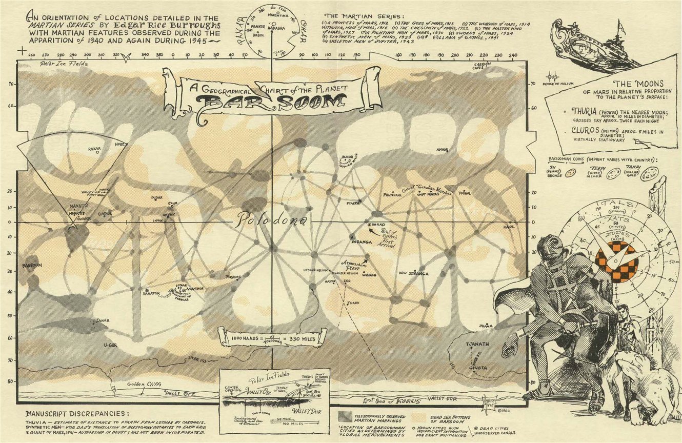
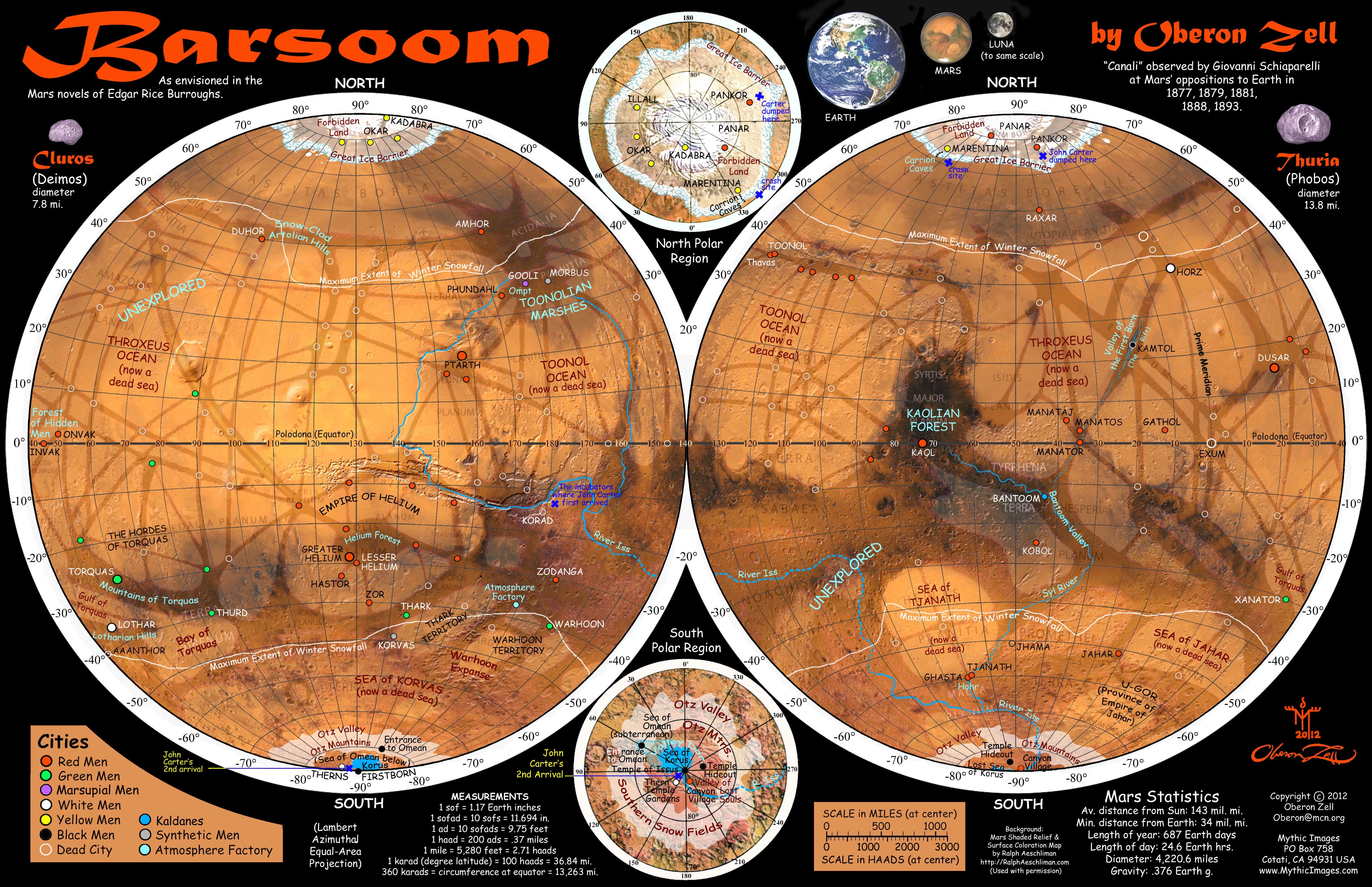
In the process of all this I've taken a great interest in the mapping aspect. I'm an amateur cartographer, very inspired by Tolkien's style, and I recently did a series of maps of ancient archaeological sites for a book called Lost Civilizations and Secrets of the Past (New Page Books, 2012). In seeking a map of Barsoom, I discovered the ERBzine fansite at http://www.erbzine.com/mag28/2807.html, with its marvelous Cartographic Study of Barsoom.
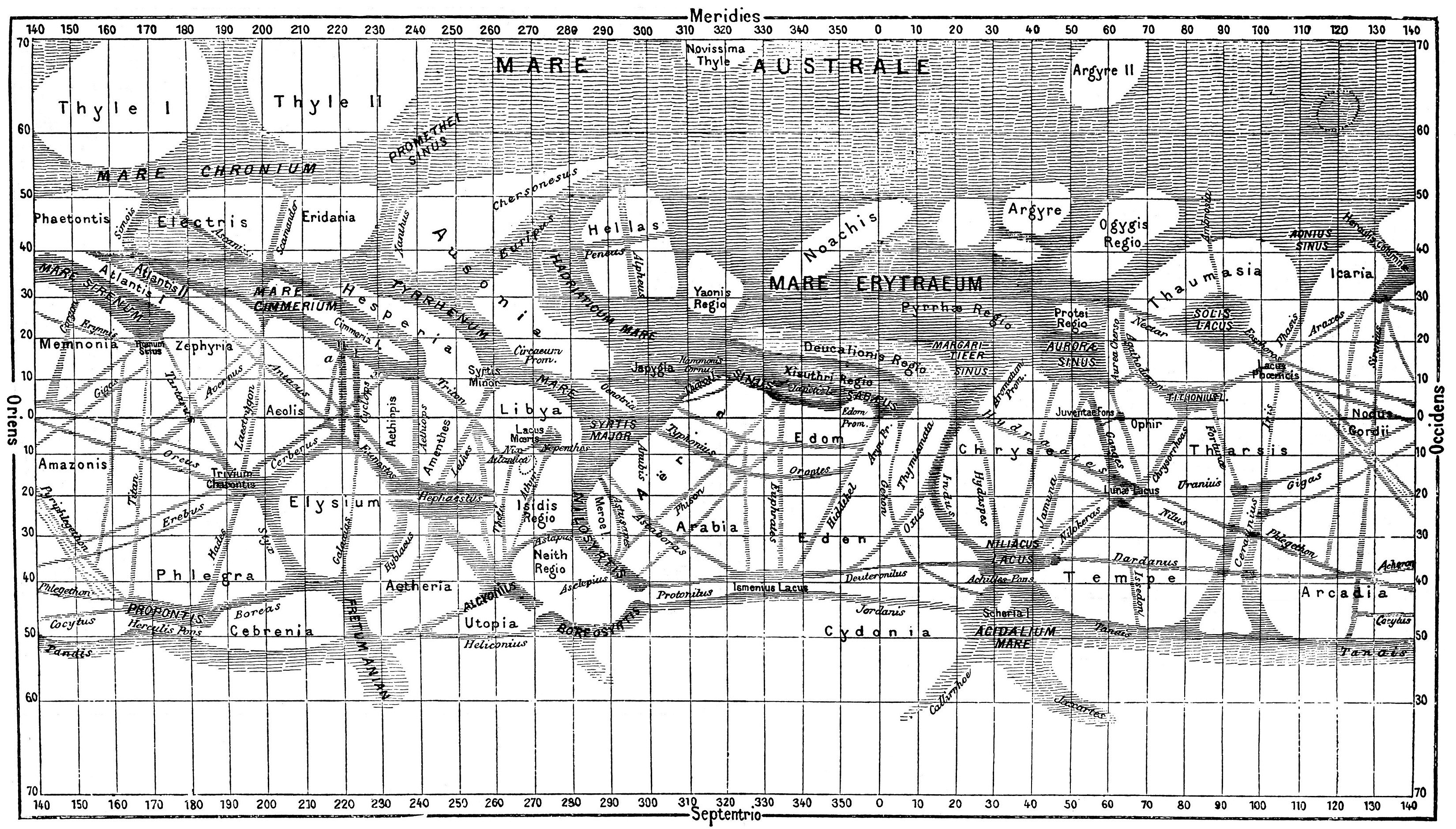
I havent seen any map of Barsoom that really satisfies me, so I decided that Id have to create one myself. In particular, the available ones seem to fall into two categories: two-hemisphere stereographic maps such as Burroughs himself drew up -- none of which indicate any relationship with actual Martian features, either Victorian or modern; or Mercator projections which often attempt to match either modern NASA Mercator imagery, or Victorian-era drawings by Shiaparelli, Antoniadi, Lowell, etc. with all the canals. I really dislike the Mercator projection for such planet maps, as the distortion is extremeespecially in the polar latitudes. For my purposes, the Lambert Azimuthal Equal-Area projection is perfect.
Burroughs, of course, had no access to our modern images of the red planet, so naturally his Barsoom was based on those delightful Victorian maps with all the "canals." Burroughs even mentions these as "waterways" connecting the cities of Barsoom, and often references locations in reference to such features leading to certain cities, such as Helium and Zodanga. So any map of Barsoom has to be laid out against those Victorian-era maps, not against modern NASA photos. This is a place where most modern Barsoomian cartographers seem to have missed the point.
Indeed, in A Princess of Mars, Burroughs writes very specifically concerning the canals of Barsoom, making it quite clear that he had those Victorian maps in mind -- specifically those by Giovanni Schiaparelli, who first observed what he called canali (Italian for channels). Shiaparelli was also the first and primary astronomer to observe parallel "canals," which Burroughs specifically references:
Taking a great diamond from her hair she (Dejah Thoris) drew upon the marble floor the first map of Barsoomian territory I had ever seen. It was crisscrossed in every direction with long straight lines, sometimes running parallel and sometimes converging toward some great circle. The lines, she said, were waterways; the circles, cities; and one far to the northwest of us she pointed out as Helium. (A Princess of Mars, Chapter 16)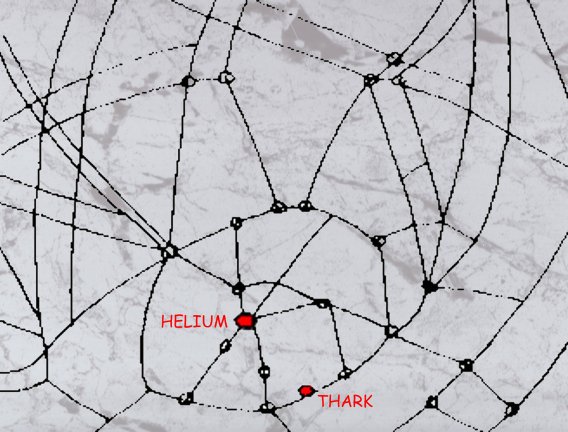
Fig. 1. Dejah Thoris' crude map of Barsoom,
scratched with a diamond on a marble floor.To my amusement, I noticed that some of the previous attempted maps of Barsoom -- such as the otherwise lovely one by Larry Ivie -- were even drawn over inverted old maps of Mars. Unfortunately, it was the custom of early astronomers to draw maps of Mars with the South at the top, rather than at the bottom, as that's how it looked through their telescopes. Since Viking, all modern maps of Mars are of course drawn with North at the top, but it is evident that many previous Barsoomian cartographers were confused by this convention. However, Burroughs did not make that error, as I discovered in my research.
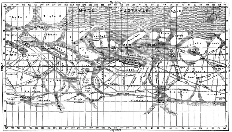
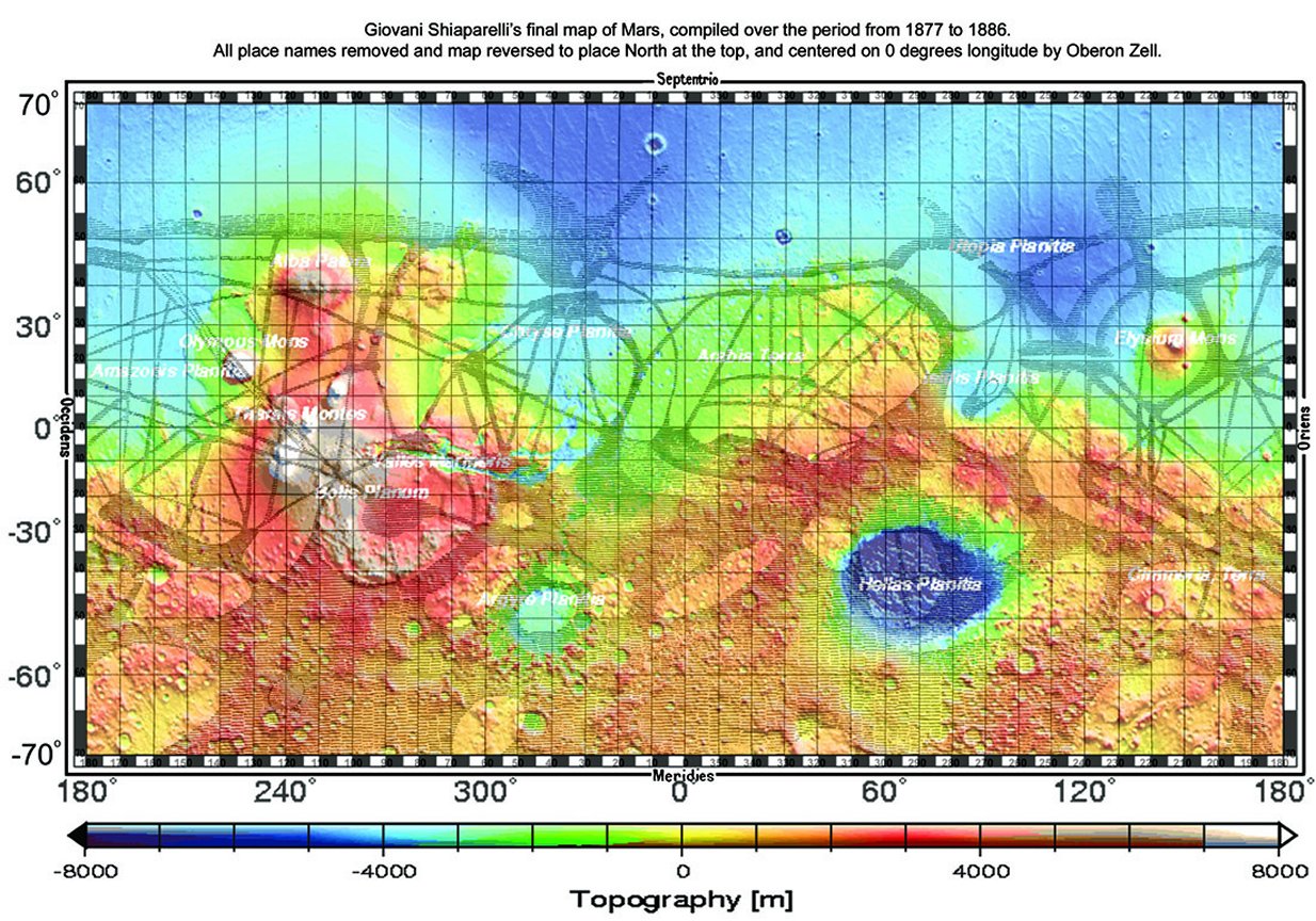
I studied all the many versions of Victorian-era maps of Mars with the "canals" (Shiaparelli, Antoniadi, Flammarion, Lowell, Bonestell, and British Astronomical Association.), and finally decided to work with Schiaparelli's final map, compiled from his observations at the oppositions of Mars in the years 1877, 1879, 1881, 1888, and 1893. I believe this is the same map that Burroughs was working with in assigning locations to his Barsoomian cities and other Martian features. (Fig. 2)
Larger | Much Larger
Fig. 2. Giovanni Schiaparellis map of Mars, compiled over the period from 1877-1886.
Schiaparellis names were mostly based on classical geography, or were simply descriptive terms --
for example, Mare Australe (Southern Sea). Many of Schiaparellis names are still in use.So in order to create my own map of Barsoom, first I had to find a perfect Lambert Azimuthal Equal-Area projection two-hemisphere image of the planet Mars as we now know it from NASA surveys. I found such a map, created by noted planetary cartographer Ralph Aeschliman, who kindly gave me his permission to use it for this project. He even supplied me with a beautiful copy devoid of detail place names and degree grids. I drew up an exact matching grid, marked at 10° intervals.
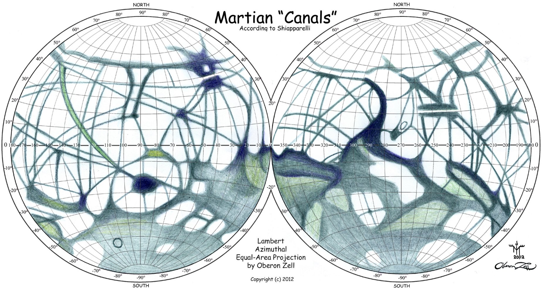
Unfortunately, Schiaparellis map is not only upside-down, with North at the bottom and South at the top; it is also a Mercator projection, and I needed a Lambert Azimuthal Equal-Area projection. Also, it is covered with Schiaparellis names for all the "canali." So I reversed Schiaparellis map, carefully removed all his labels, and then painstakingly Photoshopped it into a Lambert Azimuthal Equal-Area two-hemisphere projection. Fig. 3 is my result of this process:
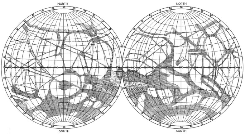
Fig. 3. Schiaparellis 1886 map, with labels removed and directions reversed to place North at the top;
Photoshopped into a Lambert Azimuthal Equal-Area two-hemisphere projection. By author.Then I carefully traced my Lambert projection of Schiaparelli's map in colored pencils, matching the shading. This would provide the working version of the Victorian-era Martian features for my map of Barsoom. (Fig. 4)
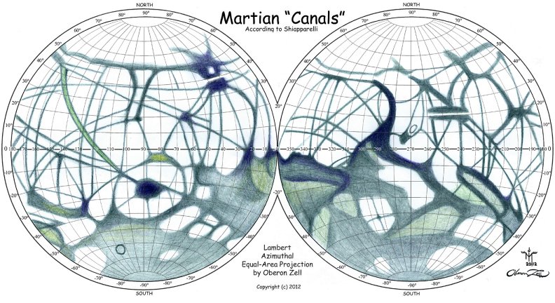
Fig. 4. Canals and other features of Mars on a Lambert Azimuthal Equal-Area projection, by the author.Next I had to work out where the identified Barsoomian cities would have to be. The first one to place, of course, had to be the twin cities of Helium. Here I took a clue from Burroughs, who says that Carter routinely translated Barsoomian terms into English. Helium (as in the 2nd element) comes from the Greek name of the Sun god, Helios. And prominent on all those Victorian maps is a major feature they called The Lake of the Sun, or Lacus Solis. With six major "canals" leading into it like spokes to the hub of a wheel, this had to be where Burroughs would have located his Helium. And at 400 miles on a side, the dark triangular "oases" of Solis Lacus is also big enough to account for the great "Forest of Helium."
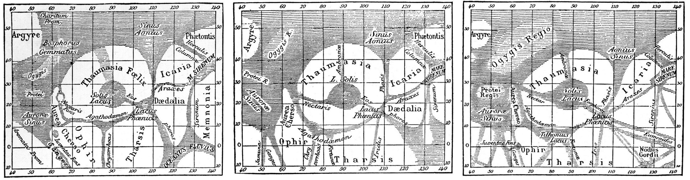
In researching Schiaparellis maps, I found that he had been particularly interested in Lacus Solis, and drew his most detailed maps of it at several oppositions. (Fig. 5) (Note that these are drawn with North at the bottom and south at the top, as was the custom of the time.)
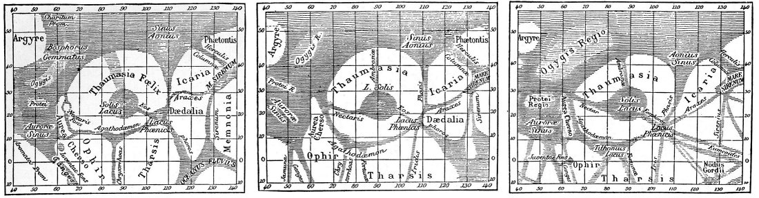
Fig. 5. The region of Lacus Solis: in 1877 (left); in 1879 (center); and in 1881 (right), according to Giovanni Schiaparelli.
(From La Planéte Mars by C. Flammarion)And indeed, Lacus Solis latitude, centered at 25° South, approximates very closely the latitude of Helium, which Burroughs stated repeatedly to be 30° South as drawn on Burroughs' very crude map. And Solis Lacus is located at 90° West from our present reckoning of the Prime Meridian, placing it right in the middle of the Western hemisphere. This is really the only reasonable location for Helium -- as well as being the only "oasis" large enough to accommodate the twin cities of Greater and Lesser Helium at a distance of 75 miles from each other. At that distance, given Mars smaller diameter than Earth's, the twin cities would be well over the horizon and completely invisible from each other -- even from the tops of their mile-high towers.
But of course, unlike latitudes, which are measured north and south from a fixed equator, degrees of longitude are measured from an arbitrary Prime Meridian, which on Mars (as on Earth) has not always been located where we place it now. Whereas our modern astronomers locate the Prime Meridian in a tiny crater within Airy in the Meridiani Sinus, Burroughs placed the Prime Meridian of Barsoom at the dead city of Exum, right on the equator. Also, note that our present degrees of longitude are measured in only one direction-- West -- so the numbers run from 0° to 360°W. However, Burroughs used an earlier system, in which degrees are marked both East and West from the Prime Meridian to 180° on the opposite side of the planet.
As all the attempted maps of Barsoom I've seen are very contradictory regarding the locations of cities, I went back and reread all eleven of Burroughs' Mars books, making extensive notes of all mentions of directions, distances, and descriptions of landmarks (such as "waterways," "dead seas," "ancient seacoasts," "mountains" and "forests"). I was fascinated to discover that the entire series of books comprises an intricate surveyor"s riddle in spherical geometry (or perhaps we should say "areometry" ), with nearly every feature triangulating with others. All that was necessary was to locate a few key points, and then plot it all out.
Referencing J.G. Huckenpöhlers excellent "Huck's Gazetteer of Barsoom" and John Flint Roy's A Guide to Barsoom (Ballantine Books, NY, 1976) as models, I developed my own expanded Gazetteer, Clues to Barsoomian Locations," which includes quotes of all the clues relevant for each location.
Burroughs says that the city of Horz is located on the Prime Meridian 1,500 miles due north of Exum (the ancient Barsoomian Greenwich), at a distance of 5,000 miles from Helium; and that a straight line between those cities bisects the equator at a point 1,600 miles (43°) east of Exum. I used a small 5" Replogle globe of Mars and a paper tape measure I made with a scale of miles to measure these distances, and the geometry gave me a location of Horz at 220° W, 40° N; thus placing Exum on the equator at 220° W. There is a prominent X-shaped conjunction of several "canals" right on the equator at that longitude. But then a 5,000-mile straight line from Helium to Horz would bisect the equator 2,575 miles east of Exum, at 140° W. As with several other locations, Burroughs has here given contradictory information; there is no way to reconcile this geometry on a globe. I suspect that he may have been using plane geometry rather than spherical, as his source maps would have been Mercator projections.
My locating of the Barsoomian Prime Meridian at 220° was confirmed by the clue given in Swords of Mars (1936):
Over 1,900 miles east of the Twin Cities of Helium, at about 30° south, longitude 172° east, lies Zodanga. (Swords of Mars, chap. 1, p. 5)
Marking a distance of 1,900 miles due east from where I've located Helium at 30°S, 90°W to this position of Zodanga on the same latitude, Zodanga lies at 32°W on a modern map of Mars. However, placing the Prime Meridian at 220°, and using Burroughs' system of indicating longitude both East and West from Exum/Horz, which I have done on this map, we find that Zodanga indeed lies at 172° West of Exum.
Using my Replogle Mars globe and tape measure, I then marked in all the other cities listed in the Chronicles at their respective distances and directions from Helium and each other. I found that Burroughs had thus triangulated enough of his Barsoomian cities to create a fairly consistent arrangement of them across the red planet. (Fig. 6)
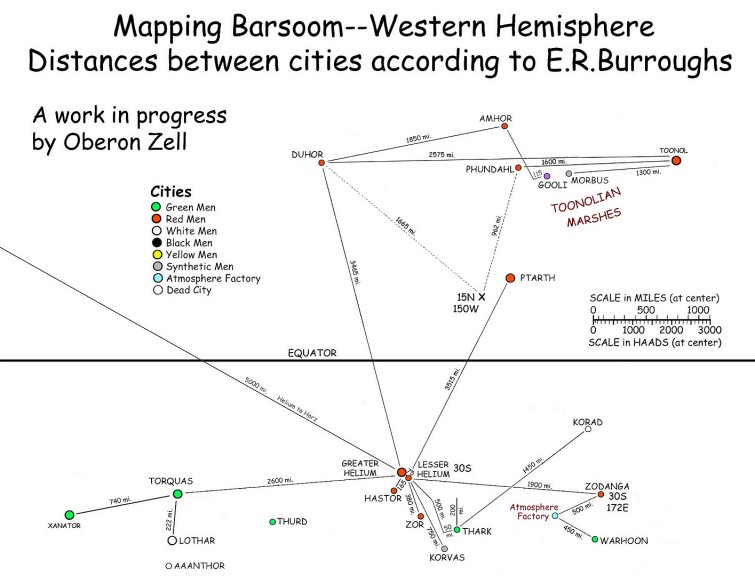
Fig. 6. Distances and directions between Barsoomian cities according to E.R. Burroughs.To match Burroughs' cities with the actual territory of the planet Mars, I overlaid the layout derived from the geometric measurements on my Azimuthal projection of Shiaparelli's map, where I was able to match them to the same features (primarily the "oases" at various intersections of canals) that Burroughs would have used. I also marked out a scale of miles (1 haad = .37 miles; 1 mile = 2.71 haads).
Once I had placed Helium at Solis Lacus, it was a straight-forward matter to match other Barsoomian cities with the "oases" at major intersections of "canals." An excellent starting clue was given in A Princess of Mars, when John Carter, Dejah Thoris and Sola conspire to escape the city of Thark:
"The great waterway which leads to Helium is but fifty miles to the south, murmured Sola, half to herself; a swift thoat might make it in three hours; and then to Helium it is five hundred miles "So all I needed to do was locate two canals that both led to Helium in the East, and a point where they are 250 miles apart, with the southern one (once reached) providing a route to Helium of 500 miles. A point 200 miles south along that line gave me the precise location of Thark -- and then all other locations fell neatly into place. See Fig. 6.
Finally, after studying the map carefully in the moonlight which now flooded the room, I pointed out a waterway far to the north of us which also seemed to lead to Helium.
Does not this pierce your grandfather's territory? I asked.
Yes, she answered, but it is two hundred miles north of us; it is one of the waterways we crossed on the trip to Thark. (A Princess of Mars, Chapter 16)I then merged Aeschlimans modern Azimuthal image with my matching map of the "canals," and overlaid them with my 10° grid.
With Helium at Solis Lacus, the city of Kaol -- which Burroughs located in the middle of a huge tropical rain-forest "which lies along the equator almost halfway around the planet to the east of Helium" (that is, about 150° to the east) -- fits right in the middle of the very prominent equatorial dark feature we call Syrtis Major. From Earth this looks just like a great forest, and it was clearly the unique feature Burroughs was referencing. As Burroughs states in The Warlord of Mars:
From books and travelers I had learned something of the little-known land of Kaol, which lies along the equator almost halfway around the planet to the east of HeliumFrom the position of Kaol on the equator, the dense dark jungle of Syrtis Major extends another 1,000 miles to the north.
The isolation of the Kaolians is rendered almost complete by the fact that no waterway connects their land with that of any other nation, nor have they any need of a waterway since the low, swampy land which comprises the entire area of their domain self-waters their abundant tropical crops
Immense trees reared their mighty heads far above us, their broad fronds completely shutting off the slightest glimpse of the sky. It was easy to see why the Kaolians needed no navy; their cities, hidden in the midst of this towering forest, must be entirely invisible from above, nor could a landing be made by any but the smallest fliers, and then only with the greatest risk of accident. (The Warlord of Mars, Chapter 3)Other than Syrtis Major, the only other large dark feature in the Northern Hemisphere is Mare Acidalium. As this is prominent on all those Victorian maps, it is the only possible location Burroughs could have had in mind for the Great Toonolian Marshes. Moreover, Burroughs says that the Marsh extends some 4,860 haads (1,798 mi.) between Phundahl on the west and Toonol on the east, and in places is 800 haads (296 mi.) in width. These dimensions -- as well as distances and directions from various cities -- exactly match the southern portion of Mare Acidalium, that Schiaparelli called Niliacus Lacus (Lake of the Nile Delta), and I have so identified it, locating its associated cities at appropriate intersections of "canals."
As I was placing all these cities, I noted frequent references to many of them being from the time of the Orovars a million years ago, when five mighty oceans rolled across what are now the ocre deserts of modern Barsoom. Ruins of Barsooms ancient dead cities may be found at the original edges of former seacoasts, with successive re-settlements following the receding seas out into the deserts, where their last remnants lie at the intersections of canals:
Upon the edges of plateaus that once had marked the shore-line of a noble continent I passed above the lonely monuments of that ancient prosperity, the sad, deserted cities of old Barsoom. Even in their ruins there is a grandeur and magnificence that still have power to awe a modern man. Down towards the lowest sea bottoms other ruins mark the tragic trail that that ancient civilization had followed in pursuit of the receding waters of its ocean to where the last city finally succumbed, bereft of commerce, shorn of power, to fall at last an easy victim to the marauding hordes of fierce, green tribesmen, whose descendants now are the sole rulers of many of those deserted sea bottoms. (Fighting Man, chap. 2, p. 164)Accurate placement of these ancient dead cities from the time of the Orovars required my creating an accurate map of ancient Mars/Barsoom with all those oceans in place. The great Hellas and Argyre Impacts that blew away most of the northern hemisphere, split open the Valles Marineris, and erupted all those immense volcanoes, are currently believed to have occurred around three billion years ago. Since Mars has no tectonic plates to move continents around and raise new mountain ranges, elevations would not have changed in the past several million years. Therefore I felt confident in using the MOLA Laser Altimeter Topographic Map of Mars (http://ltpwww.gsfc.nasa.gov/tharsis/map_lab.html) to establish the basic sea-level (at MOLAs 0-meter elevation) for the time of the Orovars. I superimposed the MOLA map over Shiaparellis 1886 Mercator projection mapwhich I turned over to place north at the top, and removed all of Shiaparellis place names (Fig. 7).
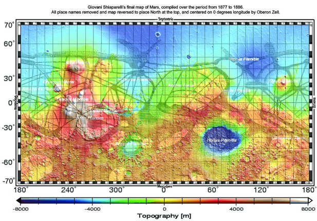
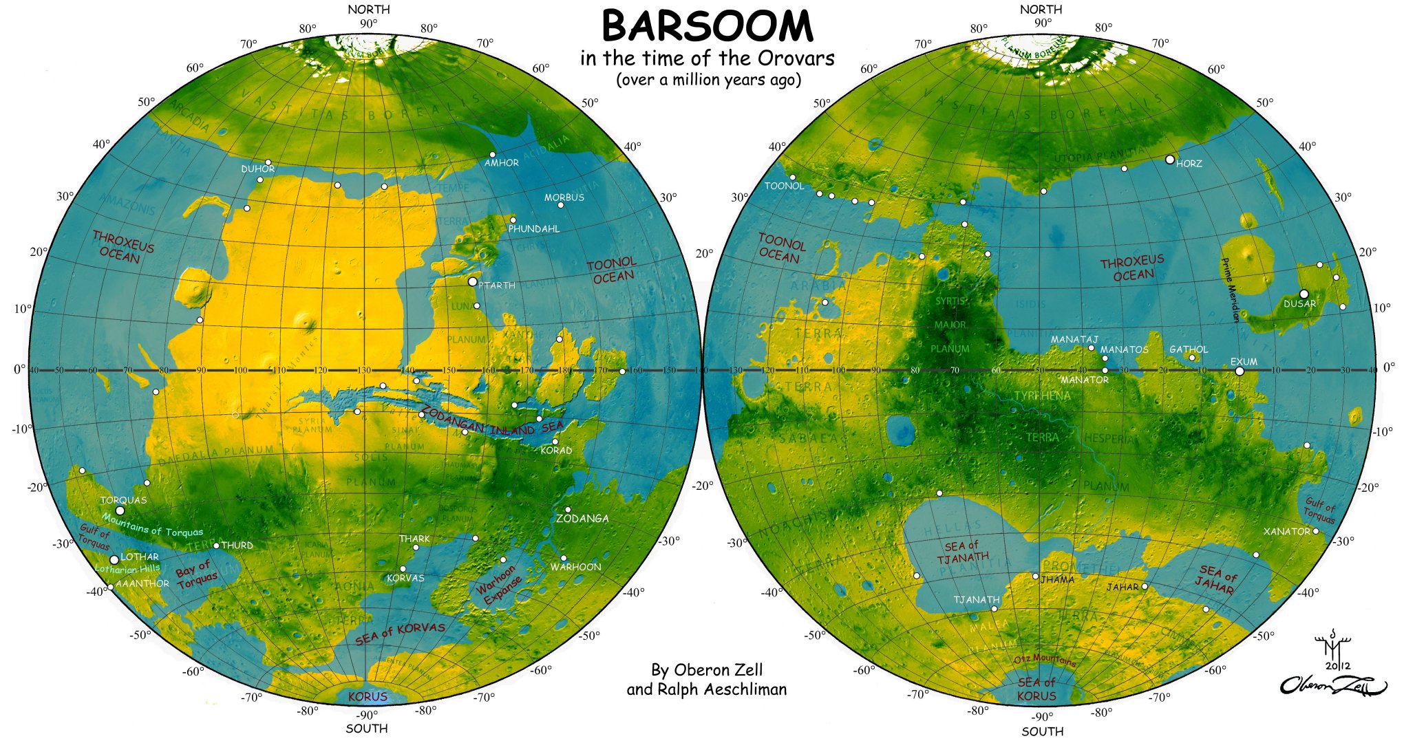
Fig. 7. Martian topography matched with Shiaparellis "canali."Then I applied that information to Ralph Aeschlimans Lambert Azimuthal Equal-Area map, and adjusted the color balance to depict a lush and fertile Barsoom in the prime of its life, over a million years ago. As the Orovars were a seafaring people, I then placed Orovar cities at suitable locations along the seacoastsmatching those named in the Chronicles (such as Horz, Lothar, etc.) with positions where Shiaparellis canalli intersected those ancient coastlines; making sure, of course, that the distances and directions remained true to Burroughs descriptions. Here is the result (Fig. 8):
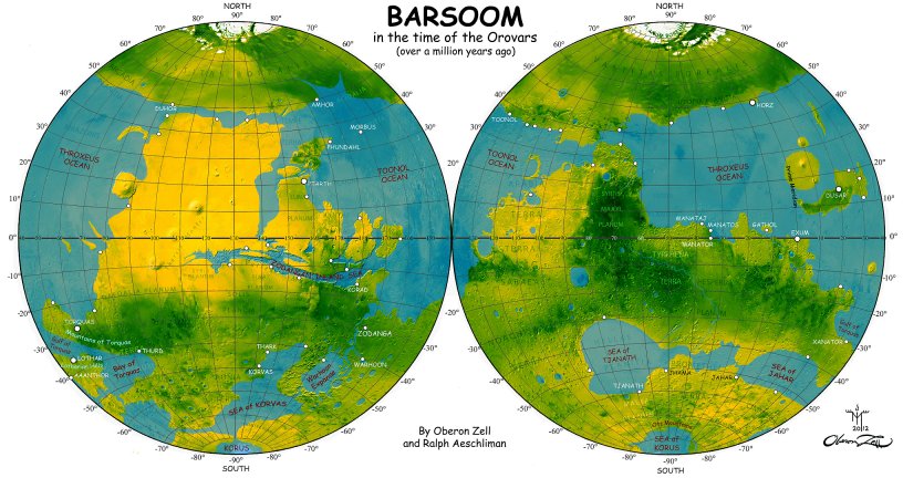
Fig. 8. Oceans of ancient Barsoomin the time of the Orovars, a million years ago.
By Ralph Aeschliman and the author.Then there was the River Iss, the course of which is impossible to determine on any of those old Victorian maps. Fortunately, our Martian probes have discovered an appropriately dramatic feature in the 3,000-mile long canyon weve named Valles Marineris. Using that as a starting point, and consulting a modern elevation map of Mars, I was able to snake the river through part of the canyon and sinuous channels to the north, from the Mare Acidalium and Niliacus Lacus (The Great Toonolian Marshes), and south to the Margaritifier Sinus east of the Valles. Interestingly, there are a number of dry sinuous channels running from the north to the south all through this region, which would not have been visible to Victorian astronomers, and which modern astronomers regard as ancient river channels. I then extended the Iss' course north and south as proposed in "Hucks Gazetteer:"
Iss, River - The sacred river of the dead. Its source, or at least its main source is probably in the Arctic icecap, but certainly as far north as the latitude of Ptarth. It flows southward, probably through Jaxartes, Mare Acidalium, Niliacus Lacus, and via the Indus to the Margaritifer Sinus, and thence from Pandorae Fretum into Hellespontus and [southern] icecap (Hucks Gazetteer of Barsoom)Another significant feature mentioned in the Chronicles is the Valley of the First Born, aka The Rift. The hidden valley of the Black Pirates, it is a long chasm, two miles deep and ten miles wide, and it lies about 925 mi. southwest of Horz. The location and position on Burroughs crude maps precisely matches that of Shiaparellis Hephaestus, providing further confirmation of my location for Horz and the Prime Meridian at 220°W.And finally, there was the matter of the Polar ice caps, which advance and recede annually from summer to winter in each hemisphere. For the maximum extent of these (the Winter snowline), I referenced the 1973 National Geographic map of The Red Planet Mars, indicating these extended Polar regions with a white line. These cover a considerable area on Mars/Barsoom, reaching towards the equator as far as the 40th parallel.
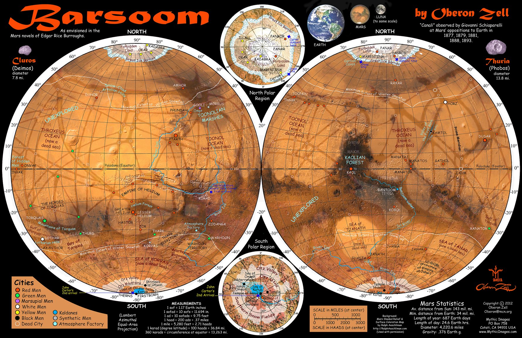
I believe I have thus accurately and consistently placed all of Burroughs' cities and other locations in accord with the Chronicles. I also placed a number of unidentified city dots at various likely "oases" that were not specifically designated by Burroughs, which fans and gamers may name and populate as they wish.
I intend to print 18"x24" posters of the final result. This is the map of Barsoom I have always wanted; and I hope you like it too. And if anyone has any corrections or suggestions for improving this map in any way, Id appreciate hearing from you. My eddress is Oberon@mcn.org, and when the posters are available, they'll be in my catalog at www.MythicImages.com.

Larger | Largest (300 dpi)
Fig. 9. A new map of Barsoom by Oberon Zell.
|
![]()
OZ with Crystal Ball Mysterious |
MEET OBERON ZELL Oberon has traveled throughout the world, celebrated Solar eclipses at ancient stone circles, raised living Unicorns, and swam with Mermaids. His love of historical and fantasy cartography may be seen in his chapter, Paradises Lost, with nine original maps, in Lost Civilizations and Secrets of the Past (New Page, 2012). Oberon is also Founder and Headmaster of the online Grey School of Wizardry, (www.GreySchool.com) which currently offers more than 450 classes in 16 Departments. Oberon lives in Sonoma County, California with his beloved lifemate, the incomparable Morning Glory. He is the primary artist of The Mythic Images Collection of which the centerpiece is his revelatory sculpture of Mother Earth as The Millennial Gaia. |
![]()
Books by Oberon Zell: Grimoire for the Apprentice Wizard (Introduced by Raymond Buckland) (New Page, 2004)
Companion for the Apprentice Wizard (Introduced by Jesse Wolf Hardin) (New Page, 2006)
Creating Circles & Ceremonies (with Morning Glory Zell) (New Page, 2006)
A Wizard's Bestiary (with Ash DeKirk; introduced by Jacques Vallee) (New Page, 2007)
Green Egg Omelette (Introduced by Christopher Penczak & Chas Clifton) (New Page, 2009)
Prophecy and the End of the World (as we know it): Apocalypse or Solartopia? (with Harvey Wasserman) (TheaGenesis, 2012)
Barsoom: A New Map of the Mars of Edgar Rice Burroughs John Carter of Mars Novels (TheaGenesis 2012)

Next in ERBzine 3938
Clues to Barsoomian locations in the Chronicles
by Oberon Zell


