Official Edgar Rice Burroughs Tribute Site
Since 1996 ~ Over 10,000 Webpages in Archive
Presents
Volume 1562
MAPPING BARSOOM II
Compromises
By Rick Johnson
MAPPING BARSOOM II
Compromises
By Rick Johnson
Unfortunately there is no perfect solution to this problem of matching Barsoom with Mars.Here is an experiment. Take a blank piece of paper and draw a map of your country freehand. Add in states, provinces, territories. Cities, rivers, everything you can remember. Be as accurate as is possible. If you are lucky, you may remember the latitude and longitude of your own city (Tucson is 32N x 111W) which you can use as a starting point (note, I just checked Topo-Zone and Tucson where I write this is really 32° 15' 45"N, 110° 57' 41"W but who cares to be that exact).
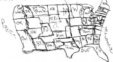
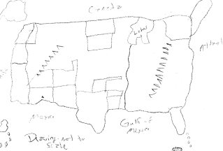
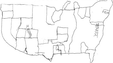
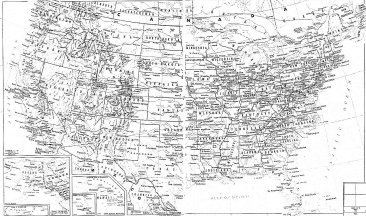
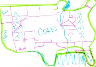 Note that all of these were drawn by adults, half by college graduates.Assignment: Draw a map of the US from memory. Add as many details as you can remember such as rivers, mountains, cities, states, etc. The west coast should be near the left side of this sheet and the east coast should be near the right side so we can overlay your drawing with a real map I have photocopied.NOW, open an atlas and place your hand-drawn map over a real map. How accurate were you? Probably not very. Yet, we persist in giving verbal directions to strangers and expect them to find the place they seek?
Create an accurate scale of distance and use this to help. (Canyon Lake is 108 miles due north of Tucson. Phoenix is about 125 miles a little west of North. Nevada, Missouri is 1200 miles NE. Albuquerque is 8 hours from Tucson east of Flagstaff. Flagstaff is three hours north of Phoenix.) Be specific, accurate, careful.
If we cannot be accurate when we describe a place we know well, how can we expect Edgar Rice Burroughs, a writer, to be accurate when describing Barsoom as described by John Carter, a soldier, when neither of them are cartographers? Even the maps drawn by John Carter were made while living on the Hudson years after leaving the Red Planet.
So, any attempt to create a workable map of Barsoom is doomed to failure. All we can do is find a happy compromise that most of us can use.
Here is my method.
I intend to create a number of maps here based on what we know form various sources, then I shall combine these into a very few possible maps of the Red Planet.
EDGAR RICE BURROUGHS
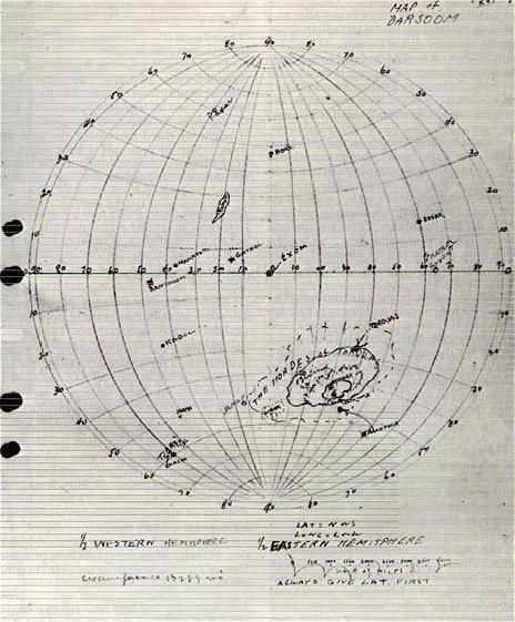
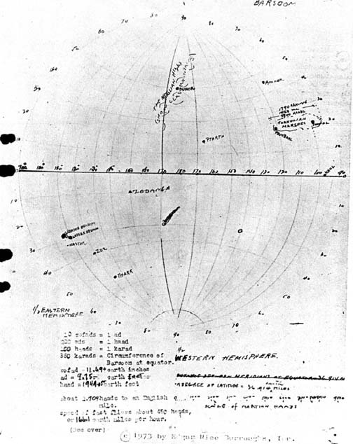
This first map was created by looking at the original sketches of Barsoom as noted by Edgar Rice Burroughs. As mentioned before, you can find these two Azimuthal maps on page 166 & 167 of An Atlas of Fantasy by J. B. Post and scanned in at
http://www.geocities.com/RikJohnson_ERB/erbbmap.htmlBarsoom According to Edgar Rice Burroughs As discussed in Part One, the more you diverge from the equator and 0 degrees Longitude, the more inaccurate the map becomes. Therefore we will use this map for reference only.
NASA
The next map was taken from the NASA-MOLA map.
It is here that we run into problems. Where do we put the equator? Where is Helium? Without any real reference points, we are simply lost for where do we start. I admit that this was my main problem until I read Den Valdrons article on Mapping Barsoom and he made a number of points to locate Gathol, Artolian Hills, Toonolian Marshes and one excellent point that we cannot ignore which is useful for all other maps. The Valley Dor!
We all used to believe that the Valley Dor and the Lost Sea of Korus were at the South Pole. All previous maps showed it there until Mr. Valdron pointed out a few problems:
1) The climate was NOT arctic but similar to that of most of Barsoom, hot during the day and cold at night. Hardly an antarctic environment.
2) Both moons could be seen in the sky and this would require a polar orbit which is countered by many references in the literature that describe the moons as rising and setting in an east-west orbit.
Therefore, Dor cannot be AT the south pole but can be NEAR the south pole.
Now consider that if you are the head of a secret religion that has almost absolute power, you dont want anyone wandering into heaven and disrupting your game-plan. Stealing an attractive slave-girl from the Plant-Men for your nefarious deeds wouldn't be as much fun when the Helium Tourist Board shows up with the Tour Guide calling out from his flyer "and to our left is a Holy Thern about to do something disgusting to a newly captured pilgrim. Let's slow down and watch for a moment."
No, you'd place Dor in as remote a place as you could find then use your power to ensure that NO ONE visited or built there. Now when we look at the Burroughs maps of Barsoom, you see a blank area that stretched from about 80 to 150 degrees west and from 10 degrees south to the south pole. Why is almost every other area on Barsoom inhabited by Green Men or Red Men but not this area?
I suspect that it is because HERE is where the Valley Dor exists and the Therns go to great lengths to keep that part of the map clear and people out.
Therefore we can pencil in Dor and Korus here. And it is here that we can start our mapping project. Look for an area that is essentially empty of the normal references
The Tharsis Montes can be the Artolian Hills. The Valley Marinaris can be the Toonolian Marshes. Elysium Mons can be Gathol so if we stretch things a bit (and there will be a lot of stretching done here, the only two places in the south that could house Korus and Dor is either Hellas Planitis or Argyre Planitis. Since the only unexplored area on Barsoom (per the Burroughs Map) is south of the Toonoliam Marsh and Southeast of the Artolian Hills, then Argyre is the only possibility for Korus simply because it is the only area in a deserted section of Mars that is even close to the possible location for Korus. And if we look at the MOLA map. We see a chain of craters and fissures that go from Argyre to Valles. Is this the River Iss?
At this time I will refer you to Den Valdrons paper on GEOGRAPHERS OF MARS I: MATCHING MARS AND BARSOOM A NEW APPROACH - ERBzine 1419 which goes into far more detail as to why we should accept this idea.
As for the Toonolian Marsh, Burroughs was specific as to the size of the Marsh being 1800 miles east to west. Yet the Valles is far larger, perhaps a dozen times as large which would seem to place it as something else.
But, The Valles is so large that were you to stand in the center, the cliff walls would be over the horizon and some of the side channels would be larger than the Grand Canyon. And There is the key. For a people who were restricted to ground travel until 900 years ago, the Valles would not be seen to exist as a separate feature simply because it is far too large to encompass. But a smaller side channel could easily trap enough water to form a marsh so the Valles isn't the Marsh, a smaller side channel of the Valles is!
And the literature describes the western edge of the Marshes as hilly which describes the mountainous regions that stretch to Tharsis.
Of course, this means that the Artolian Hills are far too close to the Toonolian marshes but frankly, did Helium perform extensive aerial surveys and photographic mapping missions when fliers were invented? If not, then I submit that there is a big difference between land and air distances. Remember the old adage where a man asks a farmer how far to the nearest Service Station. The farmer says three miles as the crow flies to which the man asks, how far if the crow is walking and carrying a flat tire? According to my GPS, I was only 300 feet from my goal last Sunday. But by the time I had docked my kayak to a tree, climbed a cliff, hiked up a mountain and around cacti and brush and gullies, I had covered more than a mile on foot to reach that 300 feet so to a man on thoat-back, the hilly distance between the Artolian Hills and the Toonolian marsh would seem much longer than to a man in a flier.
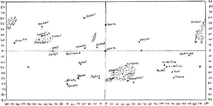
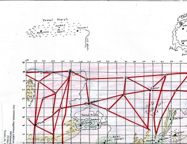
Gathol is an island in the middle of the Ocean and Elysium Mons fits that description. So if we mark on the MOLA map all the major sites, we can have a warped map of Barsoom, remembering the distortion caused by any flat map. The result is this:
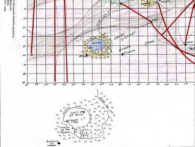
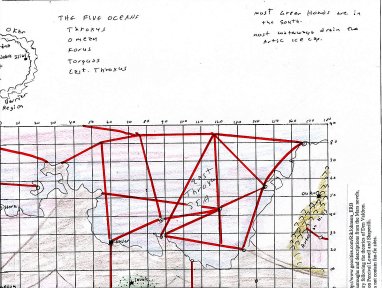
And once we redraw the MOLA map onto paper, this is the result:
As you can see, due to the limits of space I have avoided filling in every city and site on a map this small but have marked the boundary of Throxeus which may be divided into Eastern Throxus and Western Throxus which along with Korus, Omean and Torquas, give us the five oceans of Barsoom. The exact locations of the cities will be shown as we look at the MOLA map in more detail seeking craters and hills that would be moisture traps and fit the general descriptions of the explorers of Barsoom.
LOWELL
Percival Lowell was a big influence upon Burroughs and his telescopic sightings of Mars show something that the MOLA maps do not, canali. These canali are not canals but lines and resemble the waterways described by John Carter.
Unfortunately, Carter describes only a very few waterways, and these leading from Helium to the east and southeast as they cross Tharkan territory. The rest are left undescribed. Yet, when we look at Lowell, we see something interesting. Almost every waterway stretches from the north pole and few from the south. Why? The obvious answer is that the North Polar ice cap is stable in size but the southern ice cap ranges in size from so large it almost seems to cover the southern hemisphere to so small you can almost jump across it. Now, logically, if you were building a waterway system to melt polar ice and send it to the cities, taking the southern ice cap under these conditions would be technically unfeasible. You'd need collection points every few kilometers across almost half the planet. As the ice cap grew, many of these would be damaged as the water froze and glaciers grew, forcing the locals to constantly rebuild them.
But the stable northern ice cap would need only a few collection stations so it would be easier to build and maintain a system from the north and dig a waterway to the south rather than have to constantly repair expensive melting and collection stations.
So the Lowell map gives us waterways, collection stations and even more cities in the form of spots along the canali.
But again, were to start?
Korus!
There is an area in the southern region that is almost devoid of canali and other man-made features and if we place Korus there, we can move north to locate the Toonoolian March, then northwest to find the Artolian Hills and the rest falls into place. Note that I am using north as a general direction and not as a compass point for the same reason we in Tucson refer to Phoenix as north.
With Lowell, we have an advantage in that the spots at the intersections of many of the canali can easily be seen as cities surrounded by farm and grazing lands so we now know where to place the cities. The problem is to decide which spot is which city. I have concluded that Ptarth, a major city, would be a larger spot with more waterways than would be a smaller subject city. The result of this is as drawn becomes this:
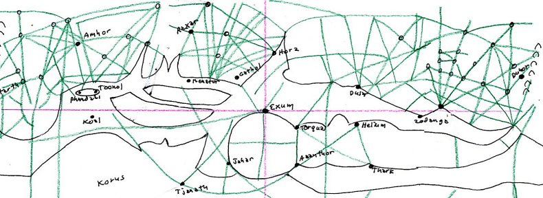
Barsoom According to Percival Lowell
FINAL MAP
What we can now do is to compromise were we must, assume that many of the directions given by John Carter were guestimates, assume that Lowell drew what he thought he saw through a small telescope and assume that the computer program used by NASA to convert the MOLA data was equal to anything created by Microsoft and we see many glitches and wonder how we can accept anything as true?
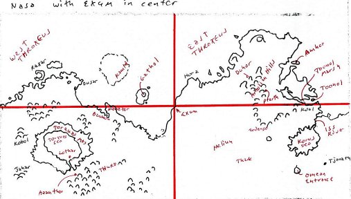
Well, we do the best we can. And for me, this means start with a large flat map marked in a grid pattern. Mine is 20 x 10 inches to give room for detail. Then I pencil in the cities as shown on the Burroughs maps. Then the features shown by the MOLA map and the waterways shown in the Lowell Map. Then I move things around until they seem to fit. The result is this:
Now I must keep in mind many things:1) Most waterways come from the North and major cities and empires would be along these waterways. EXAMPLE: The Nile River has hundreds of cities and thousands of farms along the river banks but ten miles from the river, nothing!
2) Isolated cities would be in locations away from waterways. These would be oasis cities in a deep crater or isolated by mountains which could trap and contain moisture.
3) Mountains and hills follow chains. This is because of plate tectonics where the Rocky-Andes chain is caused by the North and South American Plates smashing into the Pacific Plates and wrinkling. Mars has no modern plate tectonics but did they have any in the past?
4) Forests and marshes would be in areas that trapped prevailing winds and so collected moisture. EXAMPLE: Hawaii is lush tropical garden on the NE shore where the winds deposit water along the mountains but the SW shore is desert because by the time the winds reach that area, they have lost all their moisture. Arizona is a desert for the same reason, the western winds loose all their moisture to the Rockies and the Eastern winds drop their moisture along Texas and New Mexico.
5) Most of the older Orovar Dead cities will be along the coastline of Throxus in the north and the smaller seas of Korus and Torquas in the south. Isolated Dead cities elsewhere would be along dead rivers and lakes (craters) or the occasional oasis.
6) There are four major Green Hoards that are known. Thark, Warhoon, Torquas and Thurid. All of these are in the southern deserts. If any others exist, they would be very small, possibly cast-offs from the larger hoards and struggling to barely survive against their more numerous Red and Green foes who would gladly exterminate them.
And we see a few things that cause us to ask questions:
1) Why are the Green Hoards all in the south? Because the waterways in the north are too heavily guarded and the Red Race forced the Green Race into undesired areas. EXAMPLE: Look at how America treated the Indians for an understanding of this.
2) There is a band of green that runs from the Artolian Hills SE to the Toonolian Marsh then south to the Koal Forest, east to the Manator and Invak forests. Is this because of the wind patterns and mountains/craters acting as moisture collectors pulling snow melt from the Artolians and moving that moisture along a set flow pattern?
3) Cities like Helium that possess a forest but are isolated from this green band are generally in valleys (craters) where the caldera rims act as moisture collectors. Note that when a Barsoomian says valley he probably means asteroid impact crater and when he says hills he probably means impact crater ridge.
4) The waterways come from the stable Northern Icecap and tend to ignore the southern variable ice cap.
5) The River Iss runs from the Toonolian marsh where it takes the overflow and follows a meandering line of craters and fissures through the Koal Forest generally south to empty into Korus. The Therns would repress construction along this sacred river but build way-houses and station boats for pilgrims so you'd have a small shelter every days journey (about 20 miles or 30 kilometers). Also, as the Iss flows, it would fill an occasional crater to form small lakes and marshes which may be inhabited.
Incidentally, it is the ISS that prevents the Toonol Marsh from becoming a lake by draining the excess water. This is in the same way as the Congo River on Earth drains Africa and prevents Zaire from becoming an inland sea. Dam the Congo and in a couple centuries, central Africa would be a fresh-water lake.
When you look at this pattern, suddenly the novels make much more sense. Now the movements of John Carter and others have a reason. You can also look at the map and ask yourself, are there isolated cities in these areas? Major nations would exist along this band and Green Hoards would live in the southern deserts with occasional raids into the fertile north. Perhaps a smaller hoard, driven from the south by the Warhoons or Tharks would take refuge in the north and being so small, would be ignored as irrelevant or hunted down as a potential threat.
CONCLUSION
Remember the one thing I have been saying from the beginning, flat maps lie due to distortion so should be accepted as advisories only. Look at Greenland on a flat world map then on a round globe to see this in action. Therefore, place your cities and features on the flat map but my final suggestion would be to make a globe of Barsoom and an atlas of smaller flat maps that are specific to certain areas such as one for the Toonol Marsh, another for the Torquas Hills, another for Helium and the surrounding areas.
|
|
|
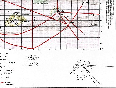
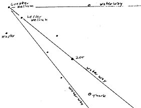
This is what I created from descriptions from the text and data from the MOLA maps. The Valley of Helium is actually a large impact crater whose walls act as moisture collectors to water the Helium Forest. Thus the prevailing winds come from the SE. The Waterways are those described by Dejah Thoris in Princess of Mars and so go SE to pass Thark and east to Zor. There are other waterways but this particular map is accurate to the Novels and not the Lowell Maps which show more waterways to the Twin Cities.
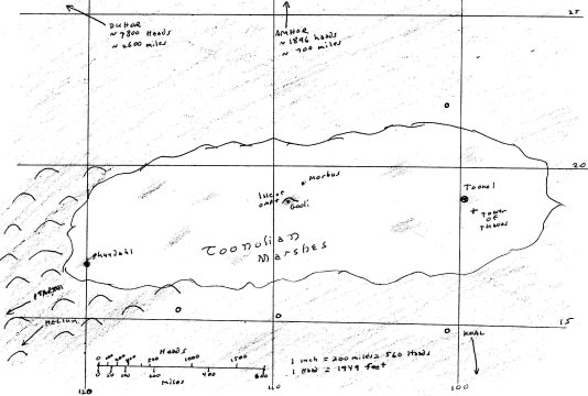
And this is the Toonolian Marsh with possible nearby cities. It shows the western mountains that help contain the Marshes and protect Phundahl from attack by air and ground.
When you are done with your own sectional maps, I would appreciate a copy for my website and I am certain that many other sites would like to see these sectional maps for as time goes, and we learn more of the Red Planet, our knowledge becomes encyclopedic.
Koar.
Next:
Fan-Fic/Pastiche additions to the Barsoom Map.
|
|
|
| ERBzine 1645: Johnson:
ERB Fan Profile
ERBzine 1522: Sociology of the Wieroo ERBzine 1527: Maltheusian Decimation in Pal-Ul-Don ERBzine 1547: Opar ERBzine 1710: Conflict! ERBzine 1965: Rescue In Pellucidar . ERBzine 1974: Anatomy of an Alien ERBzine 2304: Prelude to Weir-Lu of Caspak ERBzine 2388: Bright-Eyed Flower of Pal-ul-don ERBzine 2394: Dinosaur Survival On Earth |
ERBzine 1578: Barsoom
Questions
ERBzine 1370: Mapping Barsoom I: Can It Be Done? ERBzine 1562: Mapping Barsoom II: Compromises ERBzine 1565: Mapping Barsoom III: The Past ERBzine 1633: Valley Dor ERBzine 1634: Swords On Mars ERBzine 1711: A Panthan of Mars ERBzine 1712: Spy: Arrival On Mars ERBzine 2165: Battle at U-Gor ERBzine 2166: Lost On Barsoom ERBzine 2167: Meeting of the Panthans: Pt. I ERBzine 2168: Meeting of the Panthans: Pt. II ERBzine 2169: North to Barsoom ERBzine 2196: Jahar ERBzine 2303: Return to Barsoom I: Letters |
The ERBzine Guide to Edgar Rice Burroughs' Mars is located at:
ERBzine 1351