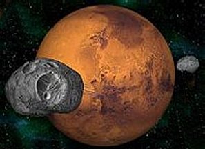
.
GEOGRAPHERS OF MARS I:
MATCHING MARS AND BARSOOM
A NEW APPROACH
CONTENTS
Introduction
Geographers
of Barsoom
Previous
Attempts to Map Barsoom
Matching
Mars and Barsoom
The
Toonolian Marshes and Valles Marinis
The
Gathol Seamount and Elysium Monte
The Artolian
Hills and Tharsis Montes
Throxeus and Forgotten
Oceans
Torquas and Hellas
Omean and the
South Polar Bulge
Other Areas On
Mars and Barsoom
River
Iss, Valley Dor, The Lost Sea of Korus and Argyre Basin
Was
Valley Dor Really at the South Pole
Megalithic Barsoom
INTRODUCTION
For ease of appreciating this effort, we recommend
that the reader reference maps of the current Mars. There are
of course, many maps of Mars on the internet showing the planet in a variety
of fascinating ways, and I highly recommend browsing through them.
I shan't violate their copyright by pirating them. They're the work
of smarter and finer people than I. But I don't hesitate to refer
you to a few...
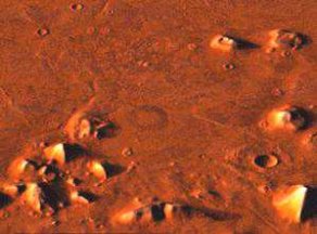
The first is of course the satellite photography
maps developed by various space probe's cameras, which contain neatly labelled
features and regions. It can be found here:
http://marsville.enoreo.on.ca/mission/linkup/event/marsmap.htm
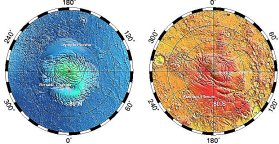
The second is the MOLA Laser Altimeter Topographic
Map of Mars, which depicts Mars through a series of false colour elevations.
Lowlands are depicted through deepening shades of blue. Intermediate
elevations are shown as greens, yellows and oranges. Highlands
are depicted as reds and browns with volcanic peaks showing white.
It can be found here:
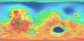
http://ltpwww.gsfc.nasa.gov/tharsis/Mars_topography_from_MOLA/
Just for the record, theres a topographic map with
features identified. But its not really interactive, and the level
of detail isnt all that great. But it might stand some convenient
cross referencing.
http://ltpwww.gsfc.nasa.gov/tharsis/map_lab.html
Ready? Keep them handy, and lets go.
GEOGRAPHERS
OF BARSOOM
Barsoomian Geography is a tricky thing with many
pitfalls for the unwary. Although distances between cities
are often given in Martian measurements or travel time, there is a complete
lack of an adequate reference point. Exum is described as the
Barsoomian Greenwich, but where is Exum? Its location is, at
best, imprecise. Certainly Earthly cartography of Mars does
not use Exum as a starting point.
It must also be remembered that the original narrators
were translating Martian terms and concepts, and Martian geography into
English. As John Carter and others discovered to the chagrin,
even tiny errors could cumulatively result in major deviations.
Accordingly, we must expect some degree of error in translating Martian
measurements to Earth terms. By the same token a reference to an
equator may be taken as either a specific point, a hypothetical midline
of the planet, or as a broad regional belt.
To render travel distances and relationships on
a circular globe involves complex referential mathematics.
Current Terrestrial society uses a global system of latitude and longitude,
but there are hypothetically other systems. We do not know
to what extent a Martian system matches the terrestrial system, or what
degrees of errors may creep in having even educated laymen translate one
system into another.
PREVIOUS
ATTEMPTS TO MAP BARSOOM
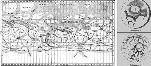
Schiaparelli's
Mars 1888
It is acknowledged that Edgar Rice Burroughs drew
crude maps to locate his John Carters adventures, he was not a cartographer.
As to his geographical skills, one might look to the Tarzan books which
deal with the Earthly and well mapped Africa. Even setting aside
endless lost cities, hidden valleys and inaccessible regions, Burroughs
grasp of geography on Earth was occasionally loose, one must assume the
same applies to Barsoom.
Moreover, his work constitutes entirely a second
hand account. He was not the source, rather, he related tales told
by John Carter. Accordingly, as a dedicated and prolific scribe,
he may be forgiven for the occasional error.
In the 1940's a substantially more elaborate map
was drafted, intended to overlay ERBs Barsoom over the map of Mars as
it was known then. That original Map of Mars has turned out
to be highly inaccurate, and so the superimposition of Barsoomian locations
must be taken as equally inaccurate. In fact, the most compelling
thing about the 1940's map is that it was an attempt, and it was clearly
ERBs intention to superimpose Barsoom onto Martian geography.
A second attempt to superimpose Barsoomian onto
Martian geography took place in 1998. It represents an astonishing
amount of work, but sadly, it lead the author to conclude that Barsoom
and Mars were two different and unrelated worlds. His map contained
numerous anomalies such as placing the Toonolian marshes in the Tharsis
mound, surrounded by and atop shield volcanoes - just about the most unlikely
spot on the planet.
One major mistake of these previous maps was to
assume that the central points of reference were the same.
The Barsoomian Globe has Exum as its zero reference point. Thats
pretty damned arbitrary. The current Martian maps are not based
on a fictional Exum, but start with their own arbitrary reference points.
Theres no chance of those reference points matching.
So, the bottom line is that in attempting to match
Barsoomian and Martian geography, we have to consider Burroughs maps, latitudes
and longitudes and distances as merely rough guides, and not definitive
points. And we cannot make the mistake of assuming that terrestrial
mapping of Mars uses the same reference points.
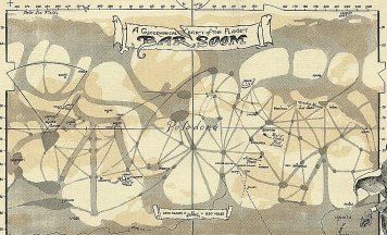
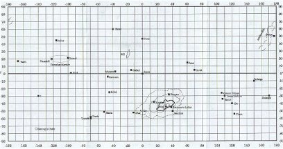
Cartography
by Larry Ivie for Readers Guide to Barsoom and Amtor
MATCHING
MARS AND BARSOOM
Lowell's
Mars
In this new approach, we would instead attempt to
establish reference points between the two planets geography.
Much of John Carters descriptions and locations refer to Barsoomian cities,
which, although picturesque, are of little assistance to us.
Similarly, visits to the north and south pole are of little help.
But along the way, Carter and the other narrators
have encountered a handful of significant geological landmarks prominent
enough that their counterparts should show up on Mars.
Principal among these are the Toonolian Marshes, the Artolian mountains,
and Gathol. Less significant, but also potentially relevant are the
forests of Invak and Kaol.
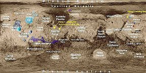
THE
TOONOLIAN MARSHES AND VALLES MARINIS
Toonolian Marshes: -- 1800 earth miles
of marsh stretching between Phundahl on the west to Toonol on the east,
narrow winding waterways connect small bodies of water, the largest of
which is a few acres in area; marsh, jungle, and water, dotted by rocky
islands which may be the remains of an ancient mountain range, often forested
by thick jungle. The area is densely populated by "fierce beasts and terrifying
reptiles, by remnants of savage aboriginal tribes long isolated."
Phundahl: west end of the Toonolian Marshes; located
near broken canyons and hills containing tracts of sompus trees to the
southwest; continually at war with Toonol.
What are the Toonolian Marshes? Theyre
one of the last vestiges of wet Mars, of the ancient Martian oceans which
once covered the planet. Are they a sea bed? Other
Marshes, around Gathol, for instance, are associated with the remnants
of Martian seas, but most of the ocean beds are already dry. Only
the deepest portions would still contain even a little moisture.
But the Toonolian Marshes arent described as being in a particularly deep
lowland. A better explanation might be that the Marshes sit upon
and are fed by deep sea canyons still filled with water. But what
canyons they must be. The Marshes are a band stretching 1800 miles,
suggesting a truly titanic canyon complex. Such a canyon complex,
even dried, would remain and be one of the most spectacular features of
the planet. Is there any such feature on our Mars?
Yes, there is. Valles Marinis, a 3000 mile
long complex of canyons up to eight miles deep, one of Mars most spectacular
and prominent features. Only the Valles Marinis canyon complex
would the one of the last great harbours of the dying martian seas.
Its immense stagnant depths and restricted surface area would prevent
its water from sublimating as quickly as in the fast flowing, shallow seas.
The Toonolian marshes are nothing less than a rain forest complex in and
surrounding the Valles Marinis aquifer.
But wait: Valles Marinis is 3000 miles long,
the Toonolian marshes are only a mere 1800 miles. Theres 1200
miles missing. So there are. The Valles Marinis complex itself
is in a process of dessication and the Toonolian marshes have been shrinking.
At the west end, Phundahl is located near broken canyons and in forested
hills, clearly a description of the drying end of the Valles Marinis.
One would expect to go further west, or perhaps
further east, and find other pockets of forest or greenery, in emptying
sections of Valles Marinis. And in fact, the Kaolian forest
may be an elevated and partially dry seciton of Valles Marinis.
THE
GATHOL SEAMOUNT AND ELYSIUM MONTE
Next up is Gathol. NW of Helium. Titled the
oldest inhabited city of Barsoom. Gathol began as an island in Throxeus
and as the ocean disappeared, the city built down the emerging seamount.
Surrounded by salt marshes, Gathol has never been conquered though many
have tried to take possession of the fabulous diamond mines beneath the
city.
Now, the city of Gathol is not nearly so important
as its location: A seamount island previously located in a
large Ocean. From what we can tell, Gathol is a unique or nearly
unique city on Barsoom, precisely because of its nature as a former seamount.
A solitary mountain is undoubtedly a shield volcano,
found on Mars, but exceedingly rare. A solitary shield volcano
in a lowland area should stick out like a sore thumb.
Well, lets just go back to our topographic map
and look around, shall we? And what do we find?
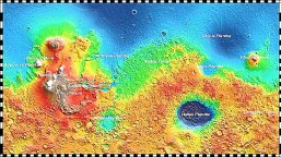
In the middle of the northern lowlands, the hypothetical location of one
of our major Martian oceans, we have a lone shield volcano Elysium Monte,
with its peak stretching some 10,000 to 16,000 meters above the surrounding
landscape. Here is our candidate for Gathol.
And Elysium Monte is broadly the right distances
and relationship to Valles Marinis as Gathol is to the Toonolian Marshes.
THE
ARTOLIAN HILLS AND THARSIS MONTES
But lets not forget about mountains, shall we.
There is another important group of mountains around Duhor. Snow
Capped Artolian Mountains. 10,500 haads NW of Helium. 7,800 haads
west of Toonolian Marshes on western side of Artolian Hills (aka Snow Clad
Mountains).
For Mars, Tectonic activity ceased early in its
history. Without tectonic plate activity, we do not get mountains.
Mountains are reported elsewhere on Mars, but I think that we can safely
say they do not compare with Terrestrial mountains. Most Martian
mountains are probably little more than hills or sharp escarpments.
Still, the Artolian mountains have a unique feature
on Mars. They are snow capped, which suggests they might be tall
enough to be actual mountains. John Carter and others refer
to the Artolians as hills, suggesting that they may be relatively gentle
rather than steep slopes. Other features are referred to as
mountains. But there is no other reference to snow capped peaks
anywhere else on Barsoom.
Are there any candidates? As a matter of fact
there are. There are a group of shield volcanoes known as Tharsis
Montes on the Tharsis bulge just to the east of Olympus Mons, and west
of Valles Marinis. Reaching heights of 12,000 meters or more
above the planetary median, the Tharsis Montes and Olympus Mons are bound
to be snow covered and constitute four out of the five major volcanoes
on the planet (the fifth is Elysium Montes).
Once again, the relationships seem to work.
The Tharsis Montes are substantially to the west of Valles Marinis, as
the Artolian Hills are to the west of the Toonolian Marshes.
Our geography of Martian cities is in general agreement.
Duhor wars with Amhor. Amhors principal economic partners are Duhor,
Toonol and Phundahl. Phundahl is in the west of the Toonolian
Marshes, further west from Phundahl you come to the Artolian mountains,
and just west of that is Duhor.
It fits into the Barsoomian geographical features
that match up with Martian geography, and there is enough space in the
Martian geographic features to fit the Barsoomian cities.
THROXEUS
AND FORGOTTEN OCEANS
John Carter refers to five oceans or seas on Mars,
only one of which is specifically referred to, Throxeus.
Throxeus is located in the northern hemisphere, but apart from that, its
dimensions and contours are uncertain.
A look at the topographic map of Mars shows us
where an immense northern ocean would have been. But this seems
to leave us a bit short. The topographic map shows only one
potential immense northern ocean in blue, and a couple of smaller blue
spots in the southern hemisphere. Three oceans or seas at best.
But look to the northern lowlands again. The
lowlands are divided by an immense peninsula moving up from the Tharsis
area and a vast seamount belt around Elysium. So, the northern
lowlands are divided into three great lobes which unite in the near polar
region.
Hence, to Martian explorers from southern or temperate
regions, the great northern ocean would appear to be three great seas or
oceans.
TORQUAS
AND HELLAS
In the southern hemisphere of Barsoom, there are
features called the Torquas Mountains, which surround a the dry bed of
a vanished body of water called the Gulf of Torquas.
In some usages, a Gulf refers to a round sea, far
larger than a bay or lake, as in the Gulf of Mexico.
Turning to the southern hemisphere of our topographic
map of Mars we find the Hellas Planitia, an immense basin formed by a huge
asteroid strike. The basin is the deepest place on Mars, and on a
wet world, would have been the site of a great sea.
As the site of a huge asteroid strike, the Hellas
area was deformed, with high ridges or mountains, known as the Syrtis highlands,
thrown up all around it.
Thus Hellas and its jagged ring of mountains forms
a fairly good match for the former Gulf of Torquas and the ringing Torquas
mountains.
Torquas, though referred to as a Gulf may well be
the fourth great sea or ocean.
And the last of the five seas? Ill
get to that.
OMEAN
AND THE SOUTH POLAR BULGE
Omean, the buried south polar sea might well be
represented by an immense four kilometer bulge of a portion of the south
polar area.
One can imagine a geological process wherein an
ancient ice cap is covered by a layer of thousands of feet of rock and
debris from a major asteroid strike, such as the south hemisphere impacts
that created Hellas and Argyre basins.
Over time internal heat, derived from the coriolis
stress of the polar axis and geological pressure causes part of the buried
ice cap to melt forming a liquid, underground sea.
Would Omean be the fifth sea referred to by Carter?
No, unfortunately. By all evidence, it was not a part of the
known ancient Barsoomian world. The final sea still awaits
us.
OTHER
AREAS ON MARS AND BARSOOM
Are there other areas which are not manmade but
which represent significant geographic features?
There are also unnamed, but large and strikingly
deep craters in roughly the correct locations for the Valley of Kamtol
in the northern hemisphere and the Valley Hohr in the southern Hemisphere.
The Valley Hohr notably, is a crater, although referred to as a volcanic
crater.
There are the forests of Kaor and Invak, near the
equator to account for. Forests suggest microclimates where
there is still enough water in the environment to support trees.
These may represent the remains of ancient isolated
seas, lakes or bays, which have retained some of their moisture.
Or they may be remnants of the water stored in the canyon complexes which
are part of Marinis Valles.
Kaor appears to be relatively near the Toonolian
marshes and may indeed be another temperate fragment of the Valles Marinis
complex.
Invak is more challenging being placed substantially
to the east of Gathol near Dusar. The most likely candidate
is the Amazonas Planitia, a sea bay of the polar ocean abutting the other
side of the Tharsis bulge and the vast Olympus Mons shield volcano.
Surrounded by highlands, backed by the immense wall
of Olympus Mons, the Amazonas Planitia is a natural collection point for
moisture.
A second, less persuasive candidate is Ieidias Planitia,
another bay located south and west of Gathol near the equator.
It too might be the site of the Invak forest, or another remnant ecological
zone sustained by higher than average moisture.
RIVER
ISS, VALLEY DOR, THE LOST SEA OF KORUS AND ARGYRE BASIN
The most challenging zone is Otz Mountains, surrounding
the golden cliffs, which contain Otz Valley and within it a section known
as Valley Dor, containing Lost Sea of Korus, all apparently nestling
inside one another like a series of russian dolls.
The Otz valley drains the immense river Iss from
the north, and holds the Valley of Lost souls between it and the South
Pole. The location is indistinct. The area is depicted as being
at the south pole, but this cannot be literally true.
The lost sea of Korus is, of course, the last of
the five seas of ancient Barsoom, and uniquely is, apart from the Toonolian
Marshes, the last major body of open water on the planet.
Whatever its true history, the Otz/Dor/Korus complex
is home to the unique plant men, a life form unknown elsewhere on
Barsoom. This suggest that the Otz/Dor/Korus complex may have
been an extremely isolated region, an ecological island zone largely
cut off from the rest of the planet where such a bizarre creature might
have evolved safely?
Once again, we have a candidate. Between latitude
-55 and -60, and longitude -60 and -30 in the southern hemisphere
is the Argyre Planitatae. A relatively small circular lowland,
of a quarter of a million square miles. It is bounded on the northwest
by the imposing Tharsis bulge, and to the northeast by the Syrtis plateau.
Directly above towards the equator is Valles Marinis. It is
the furthest south of any major depression or lowland, even slightly to
the south of the Hellas Planitatae.
Argyre seems to be a perfect site for Otz/Dor/Korus.
One factor is its isolation, only about 1900 miles from the south pole,
2400 miles from Valles Marinis, and 2700 miles from the Hellas Planitae,
it is the most isolated lowlands on the planet.
The network of sharp ridges surrounding it are effective
candidates for the Otz mountains. Its location near the southeast
end of the Tharsis mound further isolates it and may have formed an atmospheric
barrier for water loss, enhanced by the Syrtis Plateau, and protected by
the high ridges/mountains surrounding it..
Above Argyre is a slender gap between the highlands,
the potential site of the river Iss which would drain from the vicinity
of the Toonolian Marshes down into the Korus. A close up examination
of the area literally allows us to trace the course of the Iss.
The Argye is slightly closer to the south pole at
its lowest extremities than Hellas. Immediately to the south, there
is a separate large shallow depression or crater, a candidate for Valley
of Lost Souls, which brings it even closer to the south pole.
Argyre would be the logical starting point for a canal project to attempt
to drain water from the south polar cap. And in fact, we have
some evidence that this may have been done, and that there is a canal/river
connection between Korus and the south polar cap through the valley of
lost souls.
The Toonolian marshes have survived because of the
immense depth of the Valles Marinis. The Argyre Planitae is a much
shallower feature, shallower than the deep reaches of Hellas or the northern
lowlands, but it has managed to retain its water through a combination
of features, drainage from the south pole, drainage from the river Iss,
and the geographical isolation beween the Tharsis bulge and syrtis highlands.
WAS
VALLEY DOR REALLY AT THE SOUTH POLE?
Of course, traditionally, the Otz Mountains, Valley
Dor and Lost Sea of Korus are supposed to be located at the south pole
of Barsoom. A series of concentric bulls-eye rings surrounded
by the polar ice cap.
But come on now. How is this even remotely
possible. What warms the Valley Dor? Why doesnt the Sea of
Korus freeze solid? There are other anomalies to be found.
John Carter experiences days and nights in fairly normal succession.
Well, at the absolute bottom of the planet, assuming that its standing
perfectly upright with no axial tilt, you wont get days or nights, just
and endless waxing and waning twighlight.
And forget about photosynthesis in a place like
that. The Otz mountains would cast permanent shadows into the
Valley and the sea would be eternally in darkness. In fact,
there are places like this on the moon, polar craters whose bottoms are
eternally shadowed, and thus are believed to contain the moons only water.
Despite this, the Valley Dor is one of the lushest locations on Barsoom.
Or we might have a wandering axial tilt, in which
case, as on Earth, polar days would last six months, and the inhabitants
would experience a midnight sun. Again, that doesnt seem
to be the case.
Another anomaly? John Carter from the Valley
Dor observes the passage of Barsoomian moons. No way.
If these moons are at all similar in orbit to their counterparts in this
Universe, theres no way Carter could see them.
All of which goes to suggest that the Otz/Dor/Korus
complex is not located at the Martian south pole in the traditional sense,
despite Burroughs writings.
So, how do we reconcile this? There
is a solution. On Earth, we have three different sets of poles. The
magnetic poles which wander, the poles of the axis of rotation, which are
inclined and provide the earth with seasons, and the poles of axis of revolution.
Perhaps we have a similar situation on Mars in John Carters time.
Perhaps the Barsoomian axis of rotation is permanently skewed or very slow
moving (compared to earth), and that the centre of the axis of rotation
is in or at the edges of the Otz/Dor/Korus complex.
If this is the case, this might explain why Carter
can still see the Moons of Barsoom, and why the complex seems central to
rotation. If the south axis is permanently inclined towards the sun
would be a normal day night cycle with plenty of light, and the possibility
of a hospitable local climate.
In short, if we accept this hypthosis for Otz/Dor/Korus,
or if we merely set the whole thing aside, weve got an excellent set of
correspondances between real Mars and John Carters Barsoom, and within
a fifteen or twenty percent margin of error, everything seems to be where
it should be in relation to each other.
MEGALITHIC
BARSOOM