.
Barsoomian features such as the Gathol seamount, the Artolian Mountains,
the Otz/Dor/Korus Sea complex and the Toonolian Marshes are all sufficiently
distinctive geographical features that their counterparts can be easily
located and found on modern Mars.
On the other hand, non-natural features, such as the locations of Barsoomian
cities are much more difficult to pin down. These cities are often
placed in regard to each other, but often not in such a systematic manner
that would enable us to definitively place them all.
Distances are often rounded off, usually to the nearest hundred, but
over large distances to the nearest five hundred or thousand haads.
Further, the distances given are usually travel distances, so we cannot
know for sure if these are straight distances as the crow flies, or reflect
travel routes which may diverge widely from a straight path to avoid hostile
country, mountainous or impassable terrain, or unpredictable and treacherous
air currents. These are not hypothetical speculations, all
of these obstacles have been well noted and acknowledged in Burroughs books.
From time to time, Burroughs' own geography is inconsistent. Zodanga,
for instance, is referred to as being both 1000 haads from
Helium,
and 1900 haads from Helium, a 900 haad discrepancy. Further, we have
the two cities of Helium separated by 75 haads, so the real discrepancy
may be as great as 975 haads. Another city is referred to as
being in the Northwest in some editions, and the Northeast in others.
A partial solution to these discrepancies may be that there is a distinction
between the boundaries of a City State, and its Empire or lands under its
control. But this can only confuse a cartographer further.
If we accept that it is 1000 haads to the border of Zodanga, and
1900 haads to the City of Zodanga, but then what of Ptarth, Duhor, Amhor,
etc. Are distances given in measurement to borders, or the
cities proper, or interchangeably.
In short, with only Burroughs' information, it is extremely difficult
to locate cities with any precision.
The task is further complicated by divergences between terrestrial and
Martian measurements, and terrestrial and Martian cartography.
It may be a valid assumption to speculate that Martian cartography and
systems of longitude and latitude are similar to Terrestrial
ones. It is not a valid assumption to assume that they are identical.
There may be conceptual differences. Both cartography systems recognize
a fixed north pole, a fixed south pole, an equator,
a rational division into north and south hemispheres and an irrational
division into east and west hemispheres. But even here, there
may be subtle differences. On Earth we acknowledge a difference between
the north pole axis, and the north magnetic pole, we dont know
if the Barsoomians acknowledge the same difference, or which they would
follow, or if they hold to a theoretical north and south pole independent
of axial tilt. The Barsoomians have an equator, but we dont
know if they consider it a hypothetical line across the midpoint of the
planet, or a broad band of equatorial territory. John Carter
and other correspondents may attempt to interpret or transfer one to the
other, but they are not cartographers or skilled mathematicians, so certainly
there is room for error both in their interpretations and their calculations.
Finally, the Barsoomian reference point, Exum, is an arbitrary
one, not tied to any recognizeable (from Earths perspective) point of
Martian geography. Even if we can put some reliance on lines
of latitude, as a series of bands between defined poles and equator, any
attempt at longitude without a benchmark is a simple guess.
One thing to keep in mind is that Earths own system of references are
inherently arbitrary. Take a fundamental constant in Earths
system. The notion that the circle is 360 degrees.
This notion became a pivotal yardstick in cartography, subdividing the
planet into east and wests, norths and souths.
But 360 degrees is completely arbitrary. There is no justifiable
mathematical or physical reason for it. In contrast, the calculation
of pi as 3.14 is a simple equation relating to calculations of circles
that would come out the same no matter what your reference points or mathematics.
360 degrees in a circle, however, is a legacy of the first human civilization,
the Sumerians, and their obsession with base 6 counting. The Sumerian
obsession with 6's continues into many aspects of our world. 60 seconds
(6x10) in a minute, 60 minutes (6x10) in an hour, 24 hours (6x4) in a day,
7 days in a week (6 + 1 holy day), 30 days (6x5) in a month, 12 months
(6x2) in a year, years were originally believed to be 360 days (6x6x10),
juries were composed of 12 (6x2), our common math still has the concept
of a dozen (6x2). All of this is the hand me down legacy of
one obsessed origin civilization.
Well, the Barsoomians almost certainly did not have an original base
6 civilization, and even if they did, their cultures are a lot older, and
may well have abandoned that artificial trope. If in fact,
the Martians did establish a substantial planetary grid for latitude and
longitude, its more likely that they would have chosen a universal constant
like pi, 314, rather than an arbitrary one like 360.
If in fact, they did go with pi, we could expect a minor but steadily accumulating
set of errors to creep in between Earth placements and Mars placements.
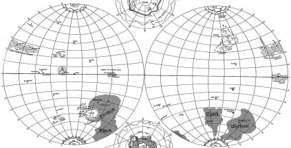
Having said that, how do we fill in a map of Barsoom on the map of Mars?
It can be done.
REFERENCING NON-NATURAL LANDMARKS TO
NATURAL ONES
The first step is to take the genuine geographical features
we can define and use them as plots for a new set of references.
These are Valles Marinis/Toonolian Marshes, the Gathol/Elysium seamount,
Tharsis Montes/Artolian Mountains, and Argyre/Otz-Dor-Korus.
Within these features, there is some built in imprecision. Gathol
is now a city at the foot of the seamount, which has a fair circumference.
Valles
Marinis extends some 3000 miles, the Toonolian Marshes between
2/3 and ½ that length. But at least we have some rough areas
to begin working with. Both Toonolian marshes and Gathol are
flexible subsets of the principle geography.
With these, we can then start relating cities to each other. Gathol,
for instance, is approximately south of Kamtol, Rexar and eventually
Pankor.
The countryside to the west is described as
salt marsh, fertile plain,
treacherous mountain/hill territory, and eventually Manator.
A number of cities and states are placed in the context of the Toonolian
marshes, including Toonol, Phundal, Amhor, Duhor and even Ptarth.
We can also begin to relate cities to geography, both past and present.
We can assume that many (but not necessarily all) dead Barsoomian cities
bordered ancient sees and oceans. By looking at the topographic map,
we can determine where the seas and oceans were, and what their approximate
borders were. With a few other clues, such as present day geography
and relationships, or a reasonably confident determination of latitude
(but not longitude), we can probably arrive at a good guess as to location.
Local geography also provides us with some clues. In the case
of Ghasta and Kamtol, both cities are located in deep valleys,
described variously as a collapsed volcanic crater and a rift.
So, we can look for these features, or features which could pass muster
such as extremely deep impact craters.
WHERE THERES RAIN . . .
Application of meteorology to geography can also help identify areas.
A number of areas are identified as being forested, Kaol, Invak, Ghasta,
Duhar, Gathol, Helium. In at least one area, there are streams
of open water flowing naturally. Forests, ponds and
water
streams all suggest areas where the moisture concentration is much
much higher than the planetary average.
How do such moisture concentrations come about? One area
where we might expect unusual fertility or dampness are the lowest parts
of sea bottoms where residual water from the oceans might
still be left, or where moisture would tend to collect. So,
particularly fertile areas may tend to be located there.
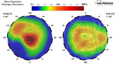
Another area would be moisture traps - geographical features
which would tend to result in moisture collecting in certain areas.
Typically, this would be lowlands adjacent to highland cliff
mountainous areas. The moisture laden air travels across lowlands,
encounters the cliffs, swirls about and moisture concentrates within the
wind
patterns generated around the geographic barriers. Bays
with
high
walls or other encircling or cornering areas would work best.
These would be additional fertile areas, and we should be on the lookout
for areas which function as moisture traps.
A final source of moisture would be evaporation or drainage from some
of the remaining principal water sources - the north pole and the south
pole. Of the two, the north pole appears to be permanently frozen.
However, the south pole is tilted towards the sun at aphelion, resulting
in a much warmer south polar summer and consequently more melting and drainage.
It is no surprise that many of the dominant cultures of Barsoom, such
as Helium, Zodanga and the Therns and Firstborn are concentrated
in the southern Hemisphere. Although the southern hemisphere
is at a higher elevation than the north, it is still lower in elevation
than the south pole itself. Therefore, south pole water will drain
northward, and the hemisphere will be on average, warmer and warmer longer
than the north.
So, with these rules, we can then proceed to locating the cities of
Mars with varying degrees of confidence.
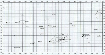
A SET OF TENTATIVE LOCATIONS
Aanthor -
- Approximately 50 degrees latitude south, 90 degrees longitude,
- on the west coast of the Hellas Basin,
- the basin was probably the major southern hemisphere sea.
- Also in the proper relationship to the Torquas mountains, assuming
that these are the parts of the ridges and cliffs that surround Hellas.
- Proper relationship to the Torquas and Thurd tribes, assuming they
occupy the Hellas basin.
- Approximately where you would find a dead coastal city.
Amhor
- Latitude 15, longitude -45.
- is located at the base of Acidalia Planitae.
- Directly above Valles Marinis.
- Acidalia Planitia is the probable location of one of the three lobes
of the northern polar ocean.
Torquas and Thurds
- Would encompass the Hellas Basin dried sea bed.
- Range approximately latitude 15 to 60, longitude 30 to 90.
- Green men tribes, territory includes Torquas mountains, stretches
to Aanthor.
- Was the Hellas Basin known as Torquas, Barsooms fourth Ocean?
Duhor
- Latitude 10, longitude -110.
- Located in Artolian mountains.
- Most likely location is lowland between Olympus mons and the three
volcanoes of Tharsis Mons.
Exum
- Latitude zero, Longitude, 165.
- Barsoomian reference point, described as several hundred haads southeast
of Gathol
Gathol surroundings
- Latitude 20, longitude 140.
- Adjacent to Elysium Planitia, and Elysium mons.
- Marshes at the base of the sea mount, probable, the volcanic shield
uplift would act as a moisture trap, resulting in wet areas.
- West of the marshes, is a broad fertile area, the deep basin of the
Utopia lobe of the Polar sea.
- West of the fertile area is mountainous broken countryside, filled
with treacherous air currents. This would be the northern extension
of the Syrtis Major Highland.
- Gathol also references Kamtol, and Raxar. Horz is an
anomalous reference point.
Helium - Approximately 30 degrees latitude south, longitude between
90 and 110
- on west coast of the Hellas Basin hinterland.
- Helium also references Hastor, Zor, Zodanga, several other very distant
cities, including Ptarth, Dusar, etc.
Kamtol, Valley of the First Born
- Latitude 45, longitude 140.
- described as being in a deep valley. There is actually a large
and extremely deep crater directly to the north of Elysium Monte
which would fit the bill.
Mountains of Torquas
- between approximately latitude -45 to -15, and longitude 30
to 60.
- Highest ridges on east side of the Hellas Basin hinterland.
Running diagonally upwards, west to east,
Invak/Onvak/Forest of Lost Men -
- latitude zero, longitude 85
- Located in the area of Isidis Planitia.
A large bay area off the Utopia Planitia, bounded by the Syrtis Major
Planum highlands. A likely area for a moisture trap.
Kaol
- Approximately 5 latitude, - 90 longitude
- Western extremity of Valles Marinis, into the Tharsis bulge, beyond
the range of the marshes. - Phundahl to the east. .
Ptarth
- Approximately latitude -30, longitude 135.
- Southern hemisphere. Located at the foot of the western
corner of the Tharsis bulge, probably moisture trap.
Jahar
- between -40 and -70 latitude and -30 to 30 longitude.
- between Hellas basin and Argyre basin, probably in the area known
as Noachis Terra,.
- Southern Hemisphere city state/empire,
- Cut off respectively by South pole, Torquas/Thurd hordes in the east,
the Torquas mountains/highlands in the north, and the forbidden Otz/Dor/Korus
complex in the west.
- Considered relatively inaccessible, and probably somewhat barren
in comparison with other areas. Essentially, an Empty section
of Barsoom as far as the Helium/Gathol/Ptarth/Duhor axis goes.
- Western side is uninhabited, with only minor principalities or ruins.
Notably, Jhama, Tjanath and Ghast. Southern side is formerly fertile
province of U-gor.
Ghast
- Believed to be located in a volcanic crater, east of Jahar.
- There are no volcanoes in the area. Perusal of topographical
map indicates several extremely deep impact craters as potential candidates.
Toonolian Marshes
- Between approximately -65 longitude and -30 longitude.
- Valles Marinis
- At or slightly south of the equator
Tharks and Warhoons
- approximately between 150 to 180, and -150 to -180 longitudes.
Probably between latitudes -45 and latitudes -75.
Terra Cimmeriaa and Terra Sirenium territories.
Approximate territory of Green man tribes, southern hemisphere.
Boundary with disorganized tribes surrounding south pole, Zodangan empire
(later Helium) in the west. Ptarth empire in east. Unknown
stretch of territory in east under Tharsis bulge to Argyre.
Manator
- somewhere between 45 and 60 latitude, and -15 to -45 longitude.
- possibly in deep northern region of Acidalia planitia,
- Northern hemisphere, west of Gathol to unknown extent,
- This would put Amhor due south, and from there the Toonolian Marsh
complex.
Bantoom
- unknown lower hemisphere area between -45 latitude -60 to -
120 longitude,
- or between Terra Sirenum and Argyre Planitia,
- probably close to the lower extremity of the Tharsis bulge forming
a water trap between the south pole and Tharsis. The streams described
are probably run offs from the Tharsis cliffs. The location would
be bounded, in addition to north and south barriers, by the Jahar city
states on the east and the Tharks and Warhoons in the west.
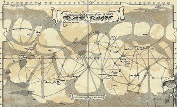
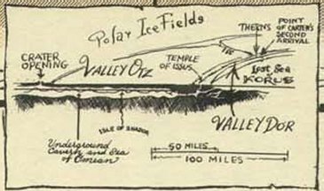
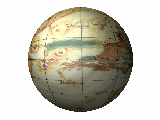
Huck's
Map of Barsoom from ERBzine 0246m
~ Den Valdron


