Official Edgar Rice Burroughs Tribute Site
Since 1996 ~ Over 15,000 Webpages in Archive
Presents
Volume 1547
OPAR
by Rick Johnson
RikJohnson@juno.com
OPAR
by Rick Johnson
RikJohnson@juno.com
Opar is a curious city. Residing in central Africa in ruins, its domes covered with gold, its vaults filled with gold and gemstones, it is obvious that the city had been built as a mining colony to feed her mother nation. But by whom?When Greystoke was led to the city by his Waziri (one of the Masai tribes of Kenya that include the Watusi and Nuer), he found a city in ruins, inhabited by beautiful white women and brutish ape-like men. The High Priestess of the city, La, told Greystoke that Opar mined gold and gemstones for the ships that visited until the ships failed to arrive.
She also informed Greystoke that for generations they had been forced to mate with the apes, killing all human males and ape-like females until they were as he saw them today.
We can discount the human-ape inter-mating for Chimpanzees share between 96-98% of their DNA with humans and yet, we are unable to breed with them. Gorillas share even less DNA so La must be referring to a man-like hominid, possibly Austrolopithicus Erectus(?) or A. Robustus(?) which is closer to Homo Sapiens yet is mistaken for an ape by the inhabitants. After all, the peoples of Borneo and Africa referred to the Gorilla and Orangutang as 'hairy men' believing that these were degenerate people so why not the reverse? Believing a Hominid is an ape?
Or more likely, due to the primitiveness of the Mangani language which was spoken by both Greystoke and the inhabitants of Opar, the word 'mangani' was used as a generic term to refer to any primate from monkey to human.
Regardless, the sexual dimorphism of the inhabitants of Opar is currently extreme.
Where did Opar come from? La never said though Greystoke believed Atlantis to be the probable origin.
The problem here is that we now know that Atlantis was an allegory used by Plato to describe the results of man being so overcome with greed, that they gave up religion and goodness for wealth. The original Atlantis as told to Solan was undoubtedly the Islands of Thera and Santorini in the Agean Sea, a marvel of the Cycladean civilization that Ancient Egypt considered to be the only other civilized nation. Its destruction by one of the most massive volcanic explosions of all known time destroyed the civilization of Crete and allowed the Greeks to rise to supremacy.
So perhaps Opar was descended from the Cycladian civilization and when Santorini blew, the regular shipping ended, leaving Opar alone and isolated.
But where is Opar?
Somewhere in Africa is all that we know. But Egypt tells of the Land of Gold called Punt from which the Egyptians collected frankincense, myrrh and gold! Then one day, Pharoah became tired of paying the caravans to visit Punt and sent an expedition by sea. They crossed the desert to the Red Sea (eventually digging a canal from the Nile to the Red Sea), sailed south to reach Punt from which they returned after two years with:
camel-leopards There is the key!
dog-faced monkeys
myrrh trees and
640 Talents of gold!Camel-leopards are giraffes, dog-faced monkeys are baboons, both of which live in the veldt with Myrrh trees. So Punt must be in the veldt of central Africa. AND, it must be reachable by sea! Both La and Egypt mention sailing ships! But Egypt has no decent wood so their ships were built like a jig-saw puzzle, stitched together and so never left sight of land. Therefore Punt must be near the coast of Africa or along a navigable river. Not an island or another continent that would be unreachable. To Egypt, if you can't see it, you can't reach it!
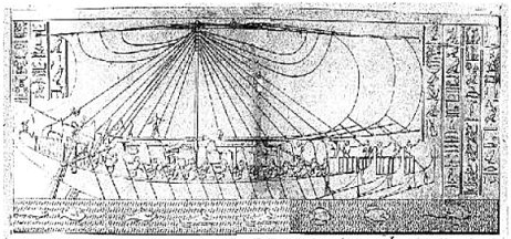
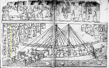
Illustration 3 (above right) shows Hatsupet's expedition to Punt. The others show the type of ship used. Some 60-80 feet long, capable of carrying 85 tons of cargo and with an average speed equal to a walking man, they were the best the world had.Years later, King Solomon, needing gold for his temple, hired Egypt to visit Punt which the Israelites called Ophir (Opar?) and so the canal to the Red Sea was cleaned and another expedition sailed forth for Egypt and Israel were far from enemies and traded religion and wealth between the two nations.
Over the centuries, Punt/Ophir/Opar became lost. Egypt had internal problems and ceased to sail to the land of Gold. The friendship between Egypt and Israel faded and one day, the ships returned with the message, "We can't find it!" Ophir became lost forever to be remembered in such literature as King Solomon's Mines by H. Rider Haggard and the memoirs of Greystoke by Edgar Rice Burroughs.
So we now know that Opar is along the African coast or a major river. We know that it is in the velt of Africa and we know that it is no more than a years sail from Egypt, probably less when you consider the time to trade and load.
Since the punt ships were square-rigged, they could sail only with the wind. There is no tacking up wind or even sailing at right angles. You sail with the wind over your stern or a few degrees off the stern and with no keel, the ship slips sideways with anything other than dead-astern winds.
Also these ships were slow, maybe travelling at three knots. There is a formula that goes: "The maximum possible speed of a sailing vessel in knots under perfect conditions is equal to 1.5 times the square root of the length of the waterline of the ship."
The Punt ships were about 60-70 feet long with a waterline length of about 45 feet. Our formulae then gives us a maximum speed of 10 knots under PERFECT conditions. This means winds in excess of 10 knots. No drag, a perfect hull, a narrow keel and so on. The truth is that when you buy a sailboat they tell you the maximum sailing speed then you ask someone who owns one and he tells you to half that. Thus the Punt ships possibly sailed at 5 knots, probably closer to three. And this was during daylight hours only for no one sailed at night. The Arabs have a saying, "only lunatics and Christians sail at night or against the wind."
So we take 12-16 hours of daylight (probably less as if you found a good place to anchor, you'd sacrifice the last few hours of daylight) at five knots gives a sailing day of between 36 miles and 80 miles (58-128 kilometers per day). Imagine a 10-11 month cruise to give you 1080-2400 miles (1738-3862 km) per month or a total distance of between 10,000-24,000 miles (17,000-38,000 km).
That's damn good sailing. Too good. You would never sail every day for you'd need to keen the hull of barnacles and worms and weed every month. The cords holding the ship together needed to be replaced, the torn sails and worn lines repaired. Your men rested. You'd never sail with all the light as you'd wake at sunrise, have breakfast, load the ship and waste morning light. You'd anchor well before dark, especially if you found a good place so sleep. And you'd trade along the way for food and information for knowledge is worth more than gold. Plus, not all days have good wind. The truth is that you'd be lucky to get a quarter of your promised distance. So we can be more realistic and say between 2,500-6,000 miles (4,000-9,000 km) away max.
Taking my calipers and a map of Africa, I move south along the west coast and find a location somewhere between the Kenya-Tanzania border and Capetown, South Africa. At 4600 miles, we reach the mouth of the Zambezi River and moving up that easily navigable waterway, we find the ancient civilization of Zimbabwe, famed for exporting ivory and gold. Yes, Zimbabwe is within the range of the Punt ships, is on the veldt and meets every condition save one! The inhabitants are Black Africans, not White.
Greystoke and Burroughs were adamant on the skin colour of the Opar women as being fair and white so where can we go? I was stuck until in the late 1960s I cam across a book by Willey Ley called Engineers Dreams. The theme of the book is that an engineer will see a mountain and instead of admiring the beauty, will think "I can cut a tunnel through that rock!" He will gaze upon the Grand Canyon and design a bridge. He will travel the Amazon River and plan a dam. It's the way they are. And in this work, Ley described the plan of a Nazi engineer who planned to build a dam across the Congo River and allow Africa to flood.
Now, according to Ley, Africa once was home to two massive lakes, the Congo and the Chad, both of which irrigated the Sahara (remember the Sahara Desert was once the Sahara Grasslands and the inhabitants sold wheat to Rome). Then one day, maybe 10,000 years ago an earthquake collapsed the walls that contained the Congo River. The ensuing flood drained Africa, turned the Sahara into a desert and much of Africa into dry veldt. By building a dam across the Congo, these pristine conditions could be recovered. (The Germans at that time had no concern for the people they would displace or drown). And here was the key!
Now if this theory was true, then the excess water from the Chad and Congo seas would have to go someplace. Some would leave via the much smaller Congo River, some north through the Sahara and Chad Rivers and some south through the Zambezi River.
There's gold and ivory and diamonds and baboons and giraffes and myrrh all along that river. Zimbabwe took advantage of what resources they found to become rich. Then the civilization died! Why?
Perhaps for the same reason that Opar died. The Congo River opened up, the central seas vanished and the Sahara and Chad Rivers vanished. But also, the Zambezi, which once was fed by the Congo Sea faded to a fraction of it's former glory. Once you could sail south along the East coast of Africa, north along the Zambezi and into the Congo Sea to the gold and diamond wealth of Zaire. Could this be where Opar is? We know that Opar was a port city for La was adamant about the ships that sailed to Opar. They didn't dock a hundred leagues away and caravan, they sailed!
Imagine, if you will, the Cycladian civilization of Crete and the nearby islands, a civilization so powerful they repressed piracy and brought peace to the Mediterranean. So powerful and of such a maritime skill that when they saw Egypt collecting the wealth of central Africa, they themselves sailed south to the Zambezi, then paddled north upstream to the richest gold fields they could find. There they built Opar and each year send ships to collect the wealth of the Congo.
Why Crete and not Egypt or some other civilization?
Because Greystoke would have recognized Egyptian influence. Because few knew of Crete and the Cycladian peoples. Because Greece had not yet risen to power and were still raiding each other in dug-out canoes. Only Crete had the technical ability to reach Africa and only Crete was unknown enough to be so exotic that Greystoke would think "Atlantis."
But there were problems. A. Robustus, commonly mislabeled 'bigfoot' or 'gorilla' or 'mangani' lived in the nearby mountains. But Robustus wasn't an ape, it was a hominid and so intelligent. Not as intelligent as their close relatives, man, but they were able to copy some of what they saw and so build the Palace of the Valley of Diamonds.
Then Santorini erupted! The biggest volcanic eruption in human history occurred destroying the Cycladian civilizations of Crete and the neighboring islands. This was followed by another disaster -- the Congo, once a small river, had finally broken through and had begun to drain the inner seas. Perhaps this had happened centuries before and the Oparians, like the Orovars of Barsoom, were concerned with the lowering of the sea upon which they depended. But one day, the Treasure Fleets failed to arrive. Crete was no more. The volcanic tsunamis created the legends of the Biblical Flood and the crossing of the Red Sea. The loss of Crete allowed the Greeks to rise to power. And as the Congo drained into the Atlantic, the Zambezi shrank to a fraction of its former glory, no longer reaching the shrinking Congo Sea and so isolating Opar.
When the Opar ships sailed out, the river they once navigated to the Indian Ocean then north to the Mediterannean was gone. No more could the now-destroyed Cretan fleets find Opar, and no more could Opar leave. They were trapped.
The Blacks along the Zambezi build Zimbabwe to take over the trade route and become powerful in themselves. Then when Egypt sailed south, instead of finding Opar, they found Punt, Zimbabwe and not caring who sold them gold and myrrh, they setteled down into a mutual trade with their new distributors.
But Opar? Limited numbers forced inbreeding and eventually, some mated, willingly or forced, with the Hominids of the Valley of the Palace of Diamonds. Thus did the degeneration of Opar commense. A. Robustus genes entered Homo Sapiens and only by mass infantcide were they able to keep the women human-looking. But at a price. The population of Opar began to fall from hundreds or thousands to dozens. By the time Greystoke arrived, there were less than a hundred Oparans left alive. A dying race doomed to extinction.
At first they continued to mine and store gold and diamonds but then forgot even that. The A. Robustus, mistaken for gorillas, continued to mine taking Africans as slaves to continue the work but not knowing why. Only that 'monkey see, monkey do' and they saw Opar mining so they copied.
Mighty Opar, dead as Mighty Crete.
All that we have left are a few descriptions and clues with which we can attempt to locate Opar and draw a map of sorts.
Here is where I believe Opar to be. You have read my reasoning. And here is what I believe it to be:
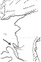
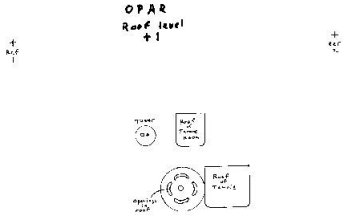
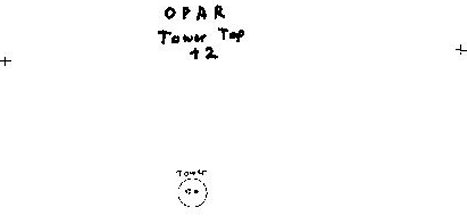
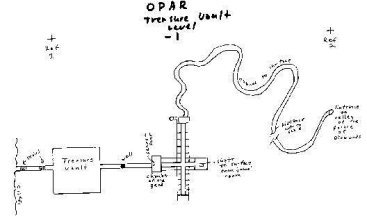
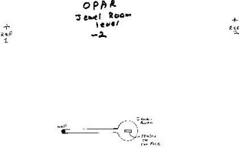
The following maps are based on the descriptions of Greystoke as he explored the dying city. To use these, note the "Ref Points" on each map. These must match as you lay the one over the other, +2 being on top, +1 next, Opar third then -1 and finally -2, and so give a three-dimensional view of Opar.
This is the top of the tallest tower known from which Greystoke observed the city ruins.
Here you see the roofs of the Temple, Throne Room and the openings into the Sacrificial Temple. Here is the ground level of Opar. You see the break in the walls that once protected the city from Africana and Robustus attacks. The well and stairs that lead down. 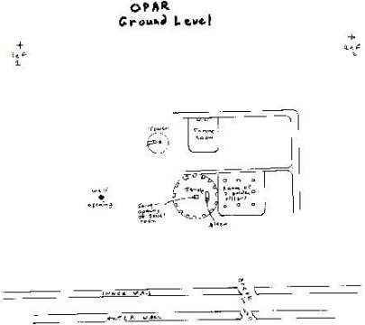
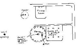
(full size of best scan available)From the well, you can take the secret corridor to the Treasure Vault and thence to the opening in the cliffs and freedom, or you can follow the corridor the other direction through a secret door forgotten by the Oparans to underground quarters to the shaft that leads to the tower and finally to the winding tunnel that eventually reaches the Valley of the Palace of Diamonds.
Here is the hidden corridor that leads from the well to the forgotten jewel room and the stairs that lead to the surface.
This then, is the remainder of the greatest civilization of all time. A few ruins on Knossus, Crete and a few ruins in Africa, the last outpost of Mighty Crete, doomed to extinction, her secrets never to be known.
Mourn for dead Crete, mourn for dying Opar. All that is left are a few grave robbers, seeking the wealth of the mightiest outpost in Africa.
Rick Johnson
PO Box 40451, Tucson, AZ 85717
http://www.geocities.com/DesertHenge
http://www.geocities.com/RikJohnson_ERB
http://www.geocities.com/RikJohnson_RLJ
WEB REFS OF INTEREST IN ERBzine
The Return of Tarzan
~ eText Edition
The Return of Tarzan
~ ERB C.H.A.S.E.R. Entry
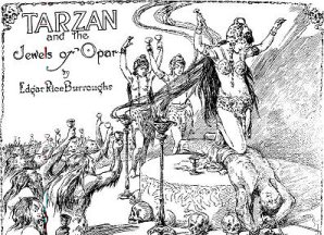
Tarzan and the Jewels
of Opar ~ eText Edition
Tarzan and the Jewels
of Opar ~ ERB C.H.A.S.E.R. Entry
Tarzan the Tiger (1929
serial with Frank Merrill)
ERBzine Refs
Rick
Johnson Feature Articles and Fiction in ERBzine
|
|
|
| ERBzine 1645: Johnson:
ERB Fan Profile
ERBzine 1522: Sociology of the Wieroo ERBzine 1527: Maltheusian Decimation in Pal-Ul-Don ERBzine 1547: Opar ERBzine 1710: Conflict! ERBzine 1965: Rescue In Pellucidar . ERBzine 1974: Anatomy of an Alien ERBzine 2304: Prelude to Weir-Lu of Caspak ERBzine 2388: Bright-Eyed Flower of Pal-ul-don ERBzine 2394: Dinosaur Survival On Earth |
ERBzine 1578: Barsoom
Questions
ERBzine 1370: Mapping Barsoom I: Can It Be Done? ERBzine 1562: Mapping Barsoom II: Compromises ERBzine 1565: Mapping Barsoom III: The Past ERBzine 1633: Valley Dor ERBzine 1634: Swords On Mars ERBzine 1711: A Panthan of Mars ERBzine 1712: Spy: Arrival On Mars ERBzine 2165: Battle at U-Gor ERBzine 2166: Lost On Barsoom ERBzine 2167: Meeting of the Panthans: Pt. I ERBzine 2168: Meeting of the Panthans: Pt. II ERBzine 2169: North to Barsoom ERBzine 2196: Jahar ERBzine 2303: Return to Barsoom I: Letters |
The ERBzine Guide to Edgar Rice Burroughs' Mars is located at:
ERBzine 1351