Official Edgar Rice Burroughs Tribute Site
Since 1996 ~ Over 10,000 Webpages in Archive
Presents
Volume 1565
|
MAPPING BARSOOM III 
The Past By Rick Johnson |
Since modern geography is based on the geology of the past, mapping Barsoom as it was a half-million years ago when the seas covered the world is easier than one would think. We actually have a number of maps that help, the one by Burroughs as described by John Carter, the one drawn by Percivel Lowell and the MOLA map by NASA. It is how we compare these that makes the difference.Consider a city like Tucson, Arizona. It's in the middle of the desert with dry washes, mountains, cacti and no water to be found within a hundred miles. So why would anyone build here? How could you survive for water, a source of constant water, is THE most important requirement for a city.
Well, the Santa Cruz River wasn't always a dry wash. Just like the Salt River, home of the Salt River Apaches, The Santa Cruz ran year-around. And it was this water source, the nearby Sentinel Peak as an early warning tower and the fertility of the desert soil that attracted the early settlers. Then the farmers took over. Pecan Groves 20 miles south sucked water from the river and a hundred miles south of them, farmers in Mexico took what they needed until today, jumping off the Grant Road Bridge into the Santa Cruz as a suicide attempt will work only if you wish to break your leg and die of thirst on the river bed months before you drown. Yet, today's city is a testament to the past geography. Ghost towns dot the courses of once flowing rivers and following one will lead you to the other.
Barsoom is no different. Ancient cities were built along sources of water that kept them alive and it is these dead cities that delineate the shorelines of the ancient seas and the water courses of the ancient rivers.
So how?
First of all, we must delete from each map all modern political features. No modern cities that were built after the seas were gone. But we must leave the ancient Orovar cities of Aaanthor and Thark, the oldest known cities of Gathol. Why? Because these define the limits of the seas in ancient times.
We know that Gathol was built upon an island in Throxeus. Therefore, we now have an island and know that this island existed within the ancient sea and where that sea once was. We know that many of the ancient Orovar and now-dead cities were built upon the shores of the ancient seas, so by leaving these, we have an idea of where these shores once lay. And we know that the Toonol Marsh was once a part of Throxeus which gives us further shorelines.
We also know that the western edge of the Toonol Marsh is bordered by hills, as are the western areas of the lands of Manator and the totality of Bantoom, both of which indicate shoreline features. Hills in the sea such as Gathol imply islands, hills on the shore imply sea-cliffs.
Now we have an idea. Not much but something to use as a base. So we turn to what maps we have.
We start with the Lowell map and we remove all the canali for if these were the waterways, then they were built after the seas dried and would cross dead sea bottom and lands with equal abandon other than the earlier lines would indicate ancient cities but how do we tell an old land canali from a new sea-bottom canali? The dark areas do give a clue. Are these desert or grassland/forest? We do know that the waterways mainly come from the North Pole so the majority of the canali imply the north pole (obviously, Lowell flipped the map he drew). Next, there is the MOLA map which is distorted as are every flat map. But the MOLA will show highlands and lowlands and with this we can begin the process of mapping the five oceans of Barsoom.
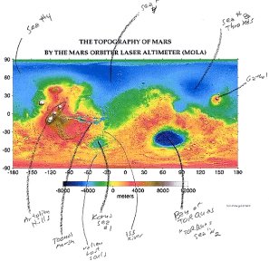
Notice that here, blue represents lowlands, red mountains, brown highlands and green moderate lowlands. Were we to assume the yellow to be seacoast, then the green becomes shallow water and the blue deep water. Thus we have our main coastline to show that much of the northern hemisphere was under water and as Throxeus was the greatest of the five seas, this must be Throxeus. We see that Elysus Mons is an island within Throxeus so this can easily be Gathol and this island proves that yellow is shore for were green to be land, then Gathol would be a peninsula, not an island. Gathol, as an island, forces us to accept green as shallow coastal seas.Hellas Planitis is the Sea of Torquas, the green Arryo Planeta is the shallow sea of Korus with that line of green craters north and then curving east becomes the River Iss which will meander around to enter Korus from the south. Why does Iss enter Korus from the South? Because the Valley of Lost Souls is near the mouth of the Iss and Korus and John Carter crossed that valley to reach Omean. Ice-bound cliffs were described which implies a near antarctic area. So the River Iss must enter Korus from the south.
That bluish strip above Argyo is the Toonol Marsh and the three white-capped mountains become the Artolian Hills.
Thus if Omean is the next ocean, then Korus, Torquas and Throxeus become four of the five. But what of the fifth?
On Earth we refer to the Seven Seas which are North Atlantic, South Atlantic, North Pacific, South Pacific, Arctic, Indian and Mediterranean even though the North and South Atlantic are one ocean. So if we look at Throxeus, we see two land masses jutting north into Throxeus, effectively dividing it into East and West Throxeus. There are our five seas: West Throxeus, East Throxeus, Torquas, Korus and Omean.
The result is shown thus:
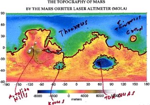
Admittedly, this is a very coarse outline but for a first draft it gives an idea of where to go. Note the coastlines shown in red. These clearly define the four main oceans of Barsoom.We also know that certain cities were Orovar sea-ports. Torquas, Aaanthor, Xanator, and by implication of this map, Exum and Horz. Thark and Warhoon, however, are inland. But Lothar was also a seaport that sailed Throxeus? How can that be when Lothar is near Aaanthor in Torquas?
I believe the answer is in York. York was a major city in England and when people moved to the New World, they brought their memories of York and called their new home, 'New' York. The Lotharians were a sea-coastal people until they were forced to migrate across the muddy marshes to found their current city. So Old Lothar would be a seacoast city and as the people migrated, they named their new home Lothar in memory of their old.
Was Torquas an isolated sea? Perhaps, but as the lands dried, the people would naturally migrate along whatever water they could find and that means that the muddy marshes they followed may well be a bay or straight that connected Throxeus to Torquas. Mola shows two possibilities, one lowland that moves north between two mountains to Throxeus and another than wanders northeast to Throxeus. Either could be the one. For simplicity I chose the northern route because as the bay dried into marsh then dried up, that would form a moisture trap to form the forest of Manator.
As the Toonol bay dried into the Toonol Marsh, the River Iss would meander south, passing through another seaport that became isolated. Being a lower area, this seaport would become the Koal Forest and Koal, once a seaport, would isolate itself for protection from the hoards desperately seeking water.
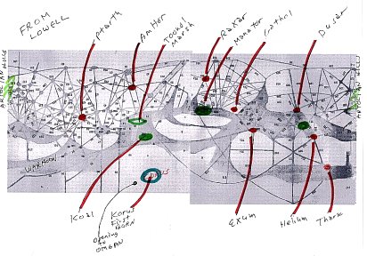
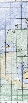
Amhor, once an island, is now a hilly region housing the new city of Amhor, resulting in this freehand drawing:
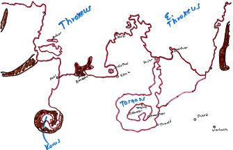
Note that the Artolian Hills are that brown ridge to the right that extends to the brown ridge on the left. Amhor is an island above a larger island that delineates the Toonol Bay (now Marsh) and the brown smudge to the left of Toonol are the Phundahl hills. With the exception of Thark and Warhoon, all cities I marked are coastal. Obviously Thark and Warhoon are either on a river or an oasis. I have no data and so no opinion on which.We now have a general idea of the place but we need more details. If we look at the Lowell map, we see strips of dark land stretching across the planet, these would be the fertile ones of forest and lush grassland with the lighter areas desert or veldt.
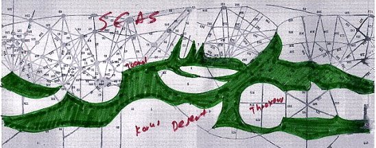
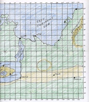
Now, if Korus were the center of the Issus religion and therefore, 'heaven', then I'd want it isolated to prevent the great unwashed masses interfering with my works by playing tourist. And as Korus probably lies within the Great Desert south of Toonol, this is where it should be. The rest of the planet now falls into place. If we ignore the canali/waterways and modern cities, we can add the lush areas such to make this:
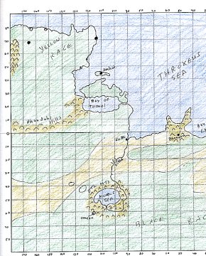
Then we see that Thark and Warhoon were farming cities and not seaports. We also see a few other dark spots from the Lowell map, some of which could be cities and others water pumping stations. Which is which?Why live at 80 degrees north in the snow if you don't have to? Look at a map of Earth. What cities do we have that far north? Honestly, none. But at 70N we see: Hammerfest & Vordo, Norway, Murmansk, Russia, and Barrow Alaska. None of which would be considered worth visiting unless you were stuck there. Even the Inuit would move south if they could. So the most northern spots would be melting and pumping stations to feed a dying planet. In fact, any spot in the ocean would be a new station so look at those along the coast or inland to reveal a number of ancient cities, including: Korad, Exum, Gathol, Amhor and a number of unnamed cities that may or may not be dead.
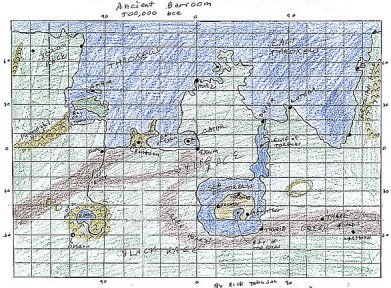
Our freehand map now looks like this:
and when cleaned up, we see the final result:Here then is what Barsoom looked like a half million years ago. Imagine the fleets of sail following the winds across the oceans, the shallow barges following the mighty Iss and Torquas Bay, the stone piers filled with bow-carrying Panthans and the unnamable fish pulled from the seas to feed the masses. See the Green hoards, small in number existing in the southern deserts vainly seeking to sack the walls of mighty Thark and Warhoon, to finally succeed as these cities were abandoned. The Orovars driven to a few isolated lands, some to intermarry for survival to form the Red Race, others to hide from Green and Red man. What wonders could we see of Barsoom at it's might, a people who turned technology not to war but to comfort.
|
|
|
| ERBzine 1645: Johnson:
ERB Fan Profile
ERBzine 1522: Sociology of the Wieroo ERBzine 1527: Maltheusian Decimation in Pal-Ul-Don ERBzine 1547: Opar ERBzine 1710: Conflict! ERBzine 1965: Rescue In Pellucidar . ERBzine 1974: Anatomy of an Alien ERBzine 2304: Prelude to Weir-Lu of Caspak ERBzine 2388: Bright-Eyed Flower of Pal-ul-don ERBzine 2394: Dinosaur Survival On Earth |
ERBzine 1578: Barsoom
Questions
ERBzine 1370: Mapping Barsoom I: Can It Be Done? ERBzine 1562: Mapping Barsoom II: Compromises ERBzine 1565: Mapping Barsoom III: The Past ERBzine 1633: Valley Dor ERBzine 1634: Swords On Mars ERBzine 1711: A Panthan of Mars ERBzine 1712: Spy: Arrival On Mars ERBzine 2165: Battle at U-Gor ERBzine 2166: Lost On Barsoom ERBzine 2167: Meeting of the Panthans: Pt. I ERBzine 2168: Meeting of the Panthans: Pt. II ERBzine 2169: North to Barsoom ERBzine 2196: Jahar ERBzine 2303: Return to Barsoom I: Letters |
The ERBzine Guide to Edgar Rice Burroughs' Mars is located at:
ERBzine 1351