Ever since Burroughs wrote the first Mars story,
people have been attempting to map the Red planet, each achieving various
degrees of success but none accurate enough for the rest of us to say,
"well, I may as well burn my attempt, this one works!"
Why is this?
We make suppositions that are completely fictitious and
counterproductive so here are the reasons why everyone fails and how we
can use these to our advantage.
FIRST, Barsoom is NOT Mars!
SECOND, Maps Lie!
THIRD, People are NOT Cartographers!
Once we compensate for these problems, most of the obstacles
facing a re-mapping of Barsoom fade away.
1:
BARSOOM IS NOT MARS!
Let us begin here.
Barsoom is a world about 4,222 miles (6,787 km) in diameter
and 13,257 miles (21, 311 km) in circumference with an atmosphere
breathable by any earth person without difficulty or trouble. We
know the size because Burroughs received these measurements from John Carter.
We know the air pressure and composition because both John Carter and Ulyssus
Paxton were transported from Earth (14.5 pounds per square inch air pressure
with a 75% Nitrogen and 25% Oxygen content) to Barsoom and could not only
breathe easily upon arrival but could do so after considerable and immediate
exercise. Therefore, the atmospheric pressure and composition was
similar to that of Earth near 2000 feet altitude in the case of John Carter
(the Superstition Mountains where John Carter is presumed to be gold hunting
starts at about 2400').
Mars, however, has an atmospheric pressure of .15 psi
(about 1/100th of Earth) with a composition of mainly Carbon Dioxide (CO2).
Appearing there suddenly would suck your lungs from your chest almost instantly.
If somehow you could concentrate the air into something equal to near Earth
pressure, you would still die within minutes from Carbon Dioxide poisoning
which causes the blood to become alkaline. There simply isn't enough
free oxygen on Mars to keep a person alive.
To understand this, Go from Miami, Florida (at sea level
@ 14.5 psi) to Denver Colorado (a mile high @ 12.5 psi) and see how easily
you can breathe. (note: Mt Everest at 29,028 feet or almost 5 miles
has an air pressure of 4.4 psi which is almost 400 times the thickness
of the air at the surface of Mars) Try to do your morning three mile
run the day after you arrive and see how far you get. When the Olympics
are situated in Mexico City or Denver, athletes arrive at least a month
ahead to get used to the thin air, to build their red count and to adapt
to the lesser air pressure before they even attempt serious exercise. Yet,
Earthmen can breathe and exercise easily on Barsoom from their first moment
of arrival with no difficulty. Neither do the local inhabitants show
no sign of overly developed rib cages to house expanded lungs. This
implies that despite claims to the rarity of the Barsoomian atmosphere,
so long as you remain under a mile of the surface, there is little difference
between Earth and Barsoom as to air composition or pressure.
The temperature of Barsoom ranges from hot during the
day to cold at night. This is comfortable enough so that both John
Carter in Helium and Ulyssus Paxton in Toonol, both at about 30 degrees
north and south respectively, can be comfortable during the day in what
amounts to little more than a g-string and a few belts to hold weapons
(note that Arizona where John Carter found his gold is at about 33 degrees
north which is similar to Helium at 30 Degrees south and both are desert).
At night, they are cold but not fatally so even when covered with but a
few layers of silk and fur blankets. Even in the South Polar region,
an area expected to be frozen, John Carter makes little to no change in
his accustomed costume which implies a relatively constant daytime temperature
across the planet changing only when the sun sets.
Mars, however, has a surface temperature well below freezing.
At 30 degrees north (the same latitude of both the Toonolian Marsh and
city of Helium) the Viking Lander measured at mid-June a nighttime temperature
of -89 degrees C (-128 F) and a daytime temperature of -25 degrees C (-12
F). This is so cold that the polar icecaps at -143 degrees C (-225 F) are
not water but frozen CO2 or dry ice. Any person would freeze solid
within minutes to become solid ice within an hour. At the Poles,
this would happen within seconds.
Barsoom is covered with reddish moss with an occasional
forest, swamp and grove of various plants. The Toonolian Marsh, the
Great Helium Forest, the Koalian Forest, the Forest of Lost Souls and the
list goes on. Vegetation abounds in sufficient amounts to feed thoats
and zitidars and with enough free water to support these forests and swamps
and enough subsurface water to support the moss which covers the sea beds.
Mars is rock! Red rock! Lots of rocks and
not one plant in sight and a humidity of Zero! No photos of
packs of calots stalking thoat herds across the countryside. No mantilla
groves or man-flowers. Nothing!
It's obvious, painfully so, that what we are seeing is
not what Burroughs is describing. Arguments here range from Barsoom
exists in a parallel universe to Barsoom is ancient history millions of
years gone.
Yet, when Dejah Thoris describes Jasoom to John Carter,
he immediately recognizes the planet of his origin. She is even familiar
with the history of the planet, a history that matches the memories of
John Carter. When Ulyssus Paxton observes Jasoom through a
Barsoomian telescope, he not only sees his own Earth, but does so in his
own time, observing the war that caused his Earthly death. What we
see when we stare with telescopes may be similar to Barsoom but what we
see when we visit is not. And neither of these resemble what both
Carter and Paxton experience in person. And somehow, what they see
when they observe Earth is accurate.
What goes?
Simple. Our observations are wrong!
2.
Remember when Science insisted that the Earth was flat?
Everything we knew about science and physics proved that the Earth was
flat! Today you can even find scientists who still insist that it
remains flat and who have successfully forced certain American schools
to teach this belief! When people experienced the curvature of the
Earth by simply sailing a few miles to sea, they KNEW that science was
wrong! Yet, scientists insisted that what these sailors had experienced
was a mass hallucination simply because science KNEW that the Earth was
flat and so the experiences of the sailors must be wrong!
Then science finally changed, accepted the experiences
of those who knew and said the Earth was round but the universe was flat!
Did they learn their lesson? No!
Some scientists have proven that the Earth was formed
3.5 billion years ago yet other scientists can just as easily prove that
the earth was created in 3007 b.c.e. Historical and geologic records
prove the validity of the former yet the latter scientists insist that
these historical records are a lie and have succeeded in getting their
beliefs taught in American schools. Once again, science disagreed
with the experiences or those who were there and science is right?
Explorers had told Naturalists for years about 'hairy
men' in the wilds of Africa to be told that this was impossible.. until
the Mountain Gorilla was discovered. Paleontologists knew for
certainty that certain fish had been extinct for millions of years.. until
the Coelocanth was discovered, still alive. And despite this list
which is greater than I wish to cover, science still refuses to consider
even the possibility that Bigfoot or the Sirrush or the Don or Chupacabra,
Megalodon, Mangani or another endless list of cryptics may exist (I myself
have discovered two cryptics in the jungles of Okinawa, a 5" diplovertebron
salamander and a 3' red centipede, both of which biologists have insisted
were fakes).
The arrogance of the scientists is as endless as is the
mistakes that they have and are and will continue to make.
I have a rule about this. Whenever someone tells
me one thing and I experience another, I ask, "Were you there?"
The scientists who insisted that the Mountain Gorilla was a fraud never
spent one moment to think, "Hey! This guy saw something, let's reserve
judgment, follow him back and see what it was." The same goes for
astrophysicists and astronomers who KNOW that Mars is lifeless despite
the visits of at least a dozen people who went there and saw the contradiction.
But I digress, rather than list the endless foibles of science from the
geocentric universe to the impossibility of apes to communicate with people
(which many still insist despite their experiences with Koko) to the impossibility
of man traveling at 60 miles per hour to. you get the idea. Science
is always making statements, proving the validity of their statements with
reams of paper and destroying the reputations of those who experienced
something else simply because the scientists KNEW that they were right
and don't confuse them with the truth.
But again I digress. This paper is about Barsoom.
Specifically, how to map the Red Planet by combining both the personal
experiences of the explorers with the observations of the astronomers.
So, when science tells me that Mars is uninhabitable yet
both John Carter and Ulyssus Paxton have been there and survived, then
I must say that NASA needs to get their heads out of their moniter and
look at the experiences of the explorers and not their own arithmetic numbers.
Numbers can prove anything even if you are using them to prove a lie!
The more exact a scientist tells me he is, the more I know he is wrong.
Like an accountant seeking to prove a balanced budget or a creationist
seeking to prove that their god created everything in 3007 b.c.e., something
has to give and I'll side with those with personal experience over someone
who never left a keyboard every time.
Therefore, the Mars described by NASA is not the Barsoom
of ERB! They are the same planet so the observations of science must
be incorrect because they counter the experiences of the explorers who
were there.
Perhaps the math is wrong. After all, Einstein could
not balance his own checkbook nor was he able to learn how to tie his shoelaces
so I tend to suspect any math described by this man.
Perhaps the observations are wrong. Maybe there
is dust in the telescopes or the lenses have warped, maybe the instruments
are measuring the wrong thing or landed in the one place that is similar
to Antartica in the Winter or Death Valley in the Summer, maybe the scientists
are misinterpreting the data. I am not a scientists but I have seen
so many scientists insist that they were right and the observations of
those who were there were wrong, then most of them had to eat crow.
So let us work from the belief that IF John Carter and
Ulyssus Paxton managed to visit and survive on Barsoom, then the planet
is habitable and the observations we have, including the temperature, air
pressure and composition and even the photos the astronomers took are inaccurate.
Why this is I will let a future scientist determine as modern scientists
laugh at the suppositions of their centuries old brethren, only to be laughed
at themselves as time passes.
3.
Since 1912 when Burroughs published the journal of Carter's
experiences upon Barsoom, people have tried with little success to compare
his descriptions to the Red planet and create a workable map of Barsoom.
In most cases, these have failed. Zodanga is described to be in two
different places. NASA photos and astronomical observations place
hills in areas that are described by Carter as flatlands. If you
map the directions given by Carter, you end up someplace different from
where he was. Even looking at the two maps drawn by Burroughs which
he based on the descriptions of John Carter don't match.
Why? Because,
MAPS LIE!
Before we go into this, we must first understand what
a map is.
A map is an attempt to describe a three-dimensional object
on a two-dimensional space. We are trying to put a round apple onto
a flat piece of paper and it simply cannot be done. For thousands
of years people have tried to do this and not one of them has succeeded.
Some maps are more accurate than others in some areas but none are correct.
Only when you create a three-dimensional sphere can you accurately map
the planet.
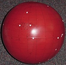
Take a soccer ball which is essentially a duo-decahedron.
That means you take twelve pentagons (a five-sided shape) and sew them
together to form a sort of sphere. Then you inflate the object to
deform the pentagons into a curve and you have a ball. Look at this
ball and as you turn it, you see every pentagon as perfect. Now set
it on the table and take a photograph of the ball. Lay some tracing
paper over the photo and trace the lines of each pentagon not as you know
them to be but as the camera shows. Look at the tracing and suddenly,
those pentagons that you know are perfect are perfect ONLY in the one facing
the camera. The further you get to the edge, the more distorted they
become. It is as of they were pushed into a narrow shape that no
longer resembles the original, yet you know they are perfect. What
you have tried to do is map a three-dimensional object in two-dimensions
and you failed.
Doing the same thing with a globe results in a similar
problem. Canada and Siberia and Greenland are shown as being unbelievable
huge on paper but when you look at a globe, they are much smaller.
But, there is hope! Cartographers have spent a thousand
years to develop a number of means to do this and although none are completely
accurate, each has its uses.
To understand this next part, instead of showing pictures
and maps, I will ask you to collect a book atlas and a cheap globe and
follow along as we explore the Earth. It doesn't matter if the atlas and
globe are out-of-date. Because political boundaries change so fast you
can easily buy both globe and atlas at any thrift store for a dollar or
two each. The globe you can paint over later and use to create your
own map of Barsoom once you understand the principles. But possession
of both of these as we talk will be invaluable.
When creating a paper map of a sphere, the only accurate
map is a Globe! Globes are three-dimensions and so accurately portray
a three-dimensional planet. But, a globe large enough to be useful
would be too large to use. I once saw in Maine the world's largest
globe which towered three stories and still, when I found Arizona on it,
the scale was to small to use. Somehow we need to make the information
on a globe workable on a desk-sized paper format and there are a number
of ways to do this.
First is the Globe which is accurate but impractical.
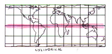 Second
is the Cylinder Projection. This takes the sphere and stretches
it to a rectangle. This is the method preferred by almost everyone
but it has a big problem. Blow up a balloon then draw the earth on
that balloon as shown on a globe. Then release the air, cut the balloon
from top to bottom and stretch it to cover a piece of paper. See
how the top of the globe distorts and stretches? Look at the shapes
of Greenland, Europe and Canada at the top of this map and compare it to
the Azimuthal map below.
Second
is the Cylinder Projection. This takes the sphere and stretches
it to a rectangle. This is the method preferred by almost everyone
but it has a big problem. Blow up a balloon then draw the earth on
that balloon as shown on a globe. Then release the air, cut the balloon
from top to bottom and stretch it to cover a piece of paper. See
how the top of the globe distorts and stretches? Look at the shapes
of Greenland, Europe and Canada at the top of this map and compare it to
the Azimuthal map below.
Any Cylindrical Projection is accurate ONLY at the exact
center of the map and along a line exactly east-west and north-south from
that center point, here marked in red. The farther you get from these
two lines, the more distortion you get. The four corners of that
Cylindrical map are so distorted as to be totally useless. Consider
that when you do this to a globe, the central east-west line in the Equator
which is some 26,000 miles from edge to edge of your map. The top
and bottom edge of the map are the same distance on paper but in reality,
they are the poles and so are a point. This is why Canada, Siberia
and Greenland look so huge. They aren't! But the Cylindrical
Projection distorts them to look that way. Compare the top of any
world map from your atlas to the same thing on your globe.
Almost all of us have tried to use this method for our Maps of Barsoom
when we seek to compare his notes from John Carter to a map of Mars.
We all fail because we forgot about the distortion at the poles and the
four corners of these maps.
Choose a point such as Ecuador on the flat map and Ecuador
on the globe. See how they match. Look north of Ecuador on
both and the farther you get from that country, the less accurate the map
becomes.
Now when you are making a map of your city, then a Cylindrical
Projection works well because for such a small area, we can assume the
world to be flat. But for anything larger, the map becomes more and
more inaccurate.
But almost every map of any place, Earth or Barsoom, is
based on this inaccurate mapping system. We take a location on a
flat Cylindrical map and measure a distance and direction and cannot help
but be wrong. Therefore, believe any flat map of Barsoom to be inaccurate!
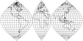 To
date the most accurate method developed is the Sinusoidal map which
resembles a peeled orange laid flat. Take your globe and cut it into
sections, each cut following a line of longitude from the north pole to
the south pole. If you cut every ten degrees, you will have thirty-six
of these pieces, each pointed at the ends and bulging in the middle as
a cat's eye. If you cut every 110 degrees, you will have the illustrated
3-section Sinusoidal map. Now lay these on your paper in proper order
and you will have an accurate map of the Earth but they will only touch
at the equator. The closer you get to the poles, the more empty space
you have. Although the sections are still curved, they are
flatter than a sphere.
To
date the most accurate method developed is the Sinusoidal map which
resembles a peeled orange laid flat. Take your globe and cut it into
sections, each cut following a line of longitude from the north pole to
the south pole. If you cut every ten degrees, you will have thirty-six
of these pieces, each pointed at the ends and bulging in the middle as
a cat's eye. If you cut every 110 degrees, you will have the illustrated
3-section Sinusoidal map. Now lay these on your paper in proper order
and you will have an accurate map of the Earth but they will only touch
at the equator. The closer you get to the poles, the more empty space
you have. Although the sections are still curved, they are
flatter than a sphere.
It is thus impossible to accurately show the entire planet
on one flat map.
What we can do is to make fairly accurate flat maps of
smaller parts of the planet. To us a basketball is a sphere but to
an ant it is flat. To us the earth is flat but to an astronaut it
is a sphere. The idea is to use a scale small enough to effectively
ignore the curvature of the Earth.
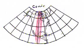
One way to do this is the Conic Projection.
Since all longitudes merge to a point at the poles and all latitudes are
parallel, the Conic Projection warps both to give a false, but still more
accurate picture of the area.
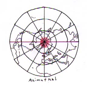
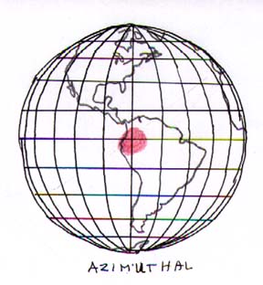
The final method is the Azimuthal Projection.
Here we take a photo of the Earth from various viewpoints and mark the
points on this map. This is the most accurate way of converting a
globe to a map but is accurate ONLY for the point exactly in the center
of the map. The closer you get to the edges, the more inaccurate
the map becomes. Burroughs used this method for his own map of Barsoom.
So the rules here are:
-
It is impossible to make a flat map of any planet that is
completely accurate.
-
Any map you make will be accurate only at the center and
the further you get from that center, the less accurate the map becomes.
So you have one choice: Make a globe that gives the
general information then make a series of flat maps to give details of
much smaller areas. A flat map of the Toonolian Marsh would be mostly
accurate as would a flat map of Omean or Helium but not of the entire hemisphere.
4.
No matter how you read the journals of John Carter or
the reworkings of Burroughs, you cannot escape the one fact of life.
MAPS LIE!
There are a lot of reasons for this that range form copyright
to security to lack of space but no map can be believed completely.
1) The former Soviet Union deliberately
made maps that were wrong, placing bridges, roads and even cities in places
miles from their actual locations, inventing military targets that did
not exist. Their thought was that if you lived in Moscow, you knew
where that bridge was and could find it but an ICBM crossing 10,000 miles
would land where the US thought that bridge was according to a map.
If we looked at a map and thought a major military base was in Siberia,
we'd sacrifice ordinance, manpower and time leveling that empty tundra
when the real base would be hundreds of miles away and safe. Even
today you must have a permit to carry a cell-phone and GPS in Russia and
anyone carrying a camera, cell-phone and GPS in America is looking to be
arrested by Homeland Security as a possible terrorist. It's happened
to Geocachers because the police and the government of many nations are
afraid that a possible enemy will get hold of an accurate map and use it
in a military manner!
2) If you want to start a company that makes and
sells maps, why spend all that money sending people out to draw the maps
and renting satellite time or aircraft when you can simply visit the library,
check out Rand-McNally and copy their map for a few cents? You can
redraw the thing and sell it cheaper because you saved all that research.
So, most map-makers put flaws into their maps. They create streets
and cities and places that don't exist. Thus, they can drag the competition
into court and say, "See, Joeblow Street doesn't really exist. We
drew it on our maps as a copyright proof because anyone who went there
would know there is no Joeblow St so since Gerber Maps shows Joeblow St,
they obviously photocopied our maps and are selling our hard work!"
3) There is only a limited space on a map.
You simply cannot put everything you want on a map that someone is trying
to read while driving down a residential street. So you aim your
map to the audience you are trying to attract and leave out items that
won't fit. For the guy who is traveling from LA to Chicago, he doesn't
care about every important historical marker, he only wants to know the
freeways, toll-roads and where to get a hamburger. So you make a
map for him and the fact that the map ignores almost every small town off
the freeway is acceptable to him.
But if you are a tourist, you don't care much about freeways,
you want to know how to get to Montezuma Well or if Walnut Creek has cliff
dwellings? If you are a delivery man, your map will show every street
in town and which are one-way but ignore historical sites.
And a map of Arizona won't have room for even the major
streets in the cities you pass. So you put the most important information
on the map according to the needs and desires of the consumer and the room
you have. My map of Tucson won't list Tohono Chul Park but it will
list the major intersections and streets. The Tucson Tourist Bureau
will give me a map that shows that intersection and the park and where
to park your car but it won't show the park itself. The Park gift
shop will give me a map that ignores the city but gives you the walking
paths through the park and notes on which areas have the best flowers to
see. Information on any map is dependant on the amount of room you
have and the interest of the consumer.
5.
PEOPLE ARE NOT CARTOGRAPHERS!
Maps were made by people who did the best they could.
They started at point A, paced off the distance to point B, turned x degrees
and passed off to point C and so on, all the while taking notes.
No matter how careful they were, even professional surveyors were often
wrong. How do we know this? Because when aircraft and cameras
were invented and satellite photography was perfected, we took a picture
from the air or space then laid that photo over the map and 'lo!' the map
was wrong. A mistake of an inch over a mile or a single degree adds
up and it took a photo from a distance to correct this. We did the
best we could and still got it wrong and if there was even the smallest
warp in the camera lens, the photo was wrong too!
When you are exploring a region, you don't have time to
roll out a 500' steel tape with compass. Even if you use a GPS and
laptop, you won't have time to do a good map. This is especially
true when you are running for your life. "Well, we ran about south
for maybe a half hour, but it seemed like a day, and then we turned to
our right and saw in the distance a big tree! That's where we buried
poor Phil!" Try to find that tree now! This is why the legendary
Pirate Maps leading to buried treasure don't work.
For most people 'south' means anything from 320 degrees
to 40 degrees. Spread your fingers and point your index finger north
according to the compass. Unless you are a professional cartographer,
those two fingers, your first and your ring will mean 'north' even though
one points NNE and the other NNW.
Here is a simple way to understand this. I live
in Tucson. My oldest daughter lives in Phoenix. I tell people
she lives 125 miles north of me. And that's all that you care to
know.
BUT!
Is Phoenix really 125 miles from Tucson? Depends!
Do we measure from city limits to city limits or from center of population
to center of population? Both these will change as people move around
and the city incorporates more land. Or from Downtown to downtown
or from main post office to main post office? Each of these will
give a measurement that varies by as much as 50 miles either way so Phoenix
can be anywhere from 100 miles to 200 miles from Tucson depending on the
places from which you or I will measure.
And is it really north? According to my map, Phoenix
is about 40 degrees west of North which actually makes it WNW. More
north than west but we here in Tucson still say that Phoenix is 'north'
of Tucson.
And does my daughter really live in Phoenix? Phoenix
is either a specific city as in the City of Phoenix or it is a group of
separate cities that all are so close together that you have to look at
the name on the police car following you to know where you really are.
There is Goodyear on the west and 25 miles east (depending on how you measure)
is Apache Junction. Between the two are: Mesa, Chandler, Peoria,
Glendale, Sun City, Scottsdale and a half dozen other cities that share
the Valley of the Sun which really isn't a valley at all but a bunch of
mountain ranges that are all over the place with a mostly flat area between
them all.
And to get there, I tell people, "go west to I-10 then
north," when I really mean, "take any road that goes in a westerly
direction until you find I-10 then follow it in a general NW direction
but winding around mountains and desert until you come across a large city
that goes on for another hour of freeway driving."
Even trained people make mistakes and suffer accidents.
I recall one time we are in the field and I noticed that we appeared to
be going in circles. So I asked the Lt. "What's going on?"
He got angry and said "We're lost!" Now this was a man who had gone
to a bunch of military schools that trained him to NOT get lost in the
desert.
So I asked, "Why not ask those people for directions.
Which elicited the reply, "They are armed with better weapons than we have
and they don't like American soldiers. Pretend you don't see them
and hope they do the same."
"Well, why not look at your compass and map?" I asked
and he replied, "Because I lost the map a while ago and I left my
compass at camp."
Finally I offered, "Here, borrow my compass and binoculars
then." I always carry back-ups for this reason.
Eventually we got back to camp safe, tired and hungry
but I had and still have no idea of where we were. But I learned
some good lessons; Don't trust another person who thinks that they know
where they are, don't rely of electronics such as a GPS, learn non-technical
methods of finding your way around and carry your own maps, compass and
survival gear.
6.
So how does this help us to understand Barsoom?
Well, the first thing is to remember that John Carter
never gave Burroughs a map. He gave descriptions. And Carter
or Paxton or Hadron were neither geographers nor cartographers. They
were soldiers trying to do a job which did not include making accurate
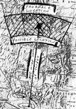
maps of the planet. So when Ulyssus Paxton said that Amhor lies "about
700 miles north of Gooli," he could have meant a broad area anywhere
from 600 to 800 miles deep with a compass heading between NNW to NNE.
That covers between 60,000 to 180,000 square miles of area or about the
size of Wisconsin or larger than England and Wales combined (on the conservative
side) and possibly as large as Sweden and larger than Morocco or Spain.
This gives us a very large area in which to search.
 Thus,
rule #1 is that unless an exact latitude and longitude is given,
be very broad in your location of the city. Incidently, we in Tucson refer
to Phoenix as being 'north' but Globe as being 'northeast' even though
I have family in both cities. Check this map for their real locations.
Thus,
rule #1 is that unless an exact latitude and longitude is given,
be very broad in your location of the city. Incidently, we in Tucson refer
to Phoenix as being 'north' but Globe as being 'northeast' even though
I have family in both cities. Check this map for their real locations.
Second, we must accept that with any flat map, distances
are accurate ONLY within a few miles of the origin. The further you
go, the more deviation we have. I took a flat Cylinder Projection
Map of Europe made by a famous map-making company. I then measured
the distance and direction from Rome (which happened to be in the center
of my map) to Moscow (which happened to be near the upper right-hand corner
of my map. I converted that map distance (6 inches) to miles (1500
miles) according to their scale and took that same measurement to my world
globe. I measured 1500 miles on the globe scale and used a rule to
go 1500 miles exactly NE from Rome. I ended up someplace past Kirov.
Kirov is, according to my flat map, about 500 miles WNW of Moscow.
Between these two maps I was 500 miles and maybe ten degrees
off. Had I programmed my Destination Compass according to my flat
map, I could easily arrive in Aaanthor facing a hoard of Torquas Green
men when I was aiming for Lothar.
Rule #2 is that the farther your directions are,
the less accurate they become.
And when we convert from one distance to another, we run
into math errors. One kilometer equals .62 miles and one mile equals
1.6 miles. So if we take 1000 km and convert to Miles, we get 620
miles. But if we convert 620 miles to kilometers, we get 992 kilometers.
This is a difference of eight miles for no other reason than the number
of decimal places we were willing to use when we mentally made the conversion.
Actually one mile equals 1.609 kilometers but how many
of us are going to use more than one decimal point when in casual conversation?
I tell people I made $26,000 last year but according to my W-2 I actually
made $26,357.31. I tell people that Phoenix is 125 miles north of
Tucson but I am only on the Freeway for 104 miles plus six miles of in-town
driving in Tucson and . you get the idea.
Rule #3 is that in normal conversation, unless
you MUST be exact, we round up or we round down. Only a computer
is exact. And when John Carter describes Thark as being a certain
direction and distance from Helium, he is guestimating both and so is probably
wrong.
So, how does this help us to map Barsoom?
 First
of all we MUST use a globe. Not a flat map, but a real globe.
Take that cheap globe I made you buy and paint it pale red. Cover
the Terrestrial images until we have a blank reddish canvas upon which
we will do our deeds. Light color is best because you need to be
able to see your markings.
First
of all we MUST use a globe. Not a flat map, but a real globe.
Take that cheap globe I made you buy and paint it pale red. Cover
the Terrestrial images until we have a blank reddish canvas upon which
we will do our deeds. Light color is best because you need to be
able to see your markings.
Next draw your lines of latitude and longitude on the
globe. Do this in 10 degree increments. Now we are making a
broad assumption here when we list 360 degrees of longitude and 90 degrees
latitude north and 90degrees of latitude south. But, I will justify
this suchly. John Carter gave so many details about measurements
such as a Haad was 1949.05 feet or a tal was .88 second, that if Barsoom
used 100 or 500 degrees on their globe, I think that this would have been
worthy of mention. Therefore, since he was silent on this even when
giving the location of a city in degrees and minutes of latitude and longitude,
"Aaanthor lies at Latitude 50o South, Longitude 40o East of Horz but the
Red Man uses 500 degrees to their circle feeling that it is easier to calculate."
No, he said 50 S by 40 E and stopped as if to imply that Barsoom used 360
degree circles too. Plus he states that a Karad is one degree or
1/360 of a circle, so, we can safely assume that the cartography of Barsoom
is the same as on Earth and use a 360o circle.
Next, from the texts we know the exact locations of a
few cities:
-
Exum is on the equator at 0 degrees E-W. Horz is on
this same 0o E-W but of an unknown Latitude and all east-west are measured
from these two cities. So mark Exum on the equator and that is now
Zero degrees or our 'Greenwich'.
-
Aaanthor is 50S x 40E
-
Dusar is 15N x 20E
-
Gathol has an area from 0N-10N x 10W-20W with a mountain
near the center
-
Jahar is 30S x 35E
-
Thark covers 40S-80S x ?
-
Twin Cities of Helium are 30S by 1900 miles W of Zodanga
Obviously I haven't given you every location on the planet
but this is a start. Feel free to re-read the journals of Barsoom
and keep a notebook by hand.
But for those cities that Burroughs described with latitude
and longitude, mark those on the globe. These are your starting points
which are considered to be authorative. Obviously according to Rule
#2, Zodanga may be at 30S or it could be as much as 10o north
or south by as much as 100 miles closer or farther away than stated.
Because of this, give Zodanga a large circle covering 20 degrees N-S by
50 degrees E-W but without a longitude for Helium, we are lost here.
Also Carter was probably working from a flat map and accepting the distortions
as fact which throws off his descriptions of distance and direction.
But wait! We have an Azimuthal map drawn by Burroughs
himself. I don't have a date for this but it shows two locations
for Zodanga and so was re-drawn as more information was given. So
we can look at this map and see that we have the lat-lon for some three
dozen cities. If we assume that this is authorative, then we now
know the exact locations of these cities. Some of these include:
-
Exum at 0 x 0 'Greenwich'
-
Horz at 0 x 48N
-
Gathol at 15W x 5N
-
Greater Helium at 106E x 28S and more. I will refer
you to An Atlas of Fantasy by J. B. Post -- pages 166 and
167 for a copy -- or check http://www.geocities
.com/RikJohnson_erb/erbbmap.html for the original maps by the Master
as an example.
Once we have marked these cities and locations, we can use
these as the base for given directions. When he then says that the
city of **** lies 'x' miles from the city of *****, we can make a
rough guess as to the locations of that city. It won't be exact but
it will get us within ten degrees or so. And when we hear a measurement
in Haads, we must be careful when we convert it to miles.
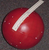
But, North or SouthWest directions and distances have
more meaning on a globe than on a map. Remember my Rome to
Moscow blunder so ten degrees latitude (from the equator of Barsoom to
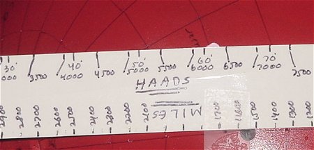
your ten degree north line) is equal to 368.2 miles. Get a soft,
flexible rule and mark this 10o on your rule. This mark
is equal to 368.2 miles or 997.4 haads. You can use this to measure
your distances on the globe. You will notice that my rule had Haads
on one side and miles on the other. It is flexible because I will
need to curve it around the globe and avoid mistakes.
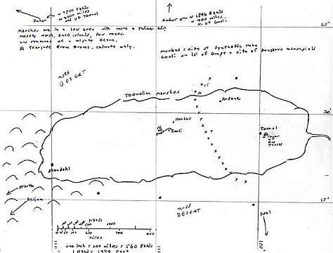
Since we know from the Burroughs chart that Amhor is at
115W x 45N and we know that Toonol is at 99W x 20N, we can mark these locations
as accurate. Then when we read that Duhor is 5000 Haads from Amhor
and 7800 Haads from Toonol, we can take our rule upon which we have marked
our distances, place the '0' point on Amhor and draw a circle then repeat
at Toonol. Where these two circles intersect is the approximate location
for Duhor (simple trigonometry). And as we know that the Artolian
hills are east of Duhor, we can map those too.
Add as many details as you can such as the boundaries
for the Artolian Hills and the Toonol Marsh. Estimate the Koal and
Invak forests. Draw the known valleys of Kamtol and Torquas. Here is where
you must be careful but imaginative. Note that Carter describes the
Valley Dor as 'near the south pole', not "at" the south pole. This
is important because a) John Carter could easily see both moons from the
Valley, b) the Valley was not covered in ice but had temperate climate
and c) John Carter wasn't freezing in Dor as he was in Okar. Therefore
Dor must be in the southern hemisphere but not at the south pole, obviously
in a remote location with few cities. We shall return to this later.
Now that we have marked as many locations as we can on
our globe, we take graph paper, mark our lat-lon numbers with a heavier
line for the equator and Exum and transfer our cities from the globe to
the Cylindrical Projection map that we have just drawn. Why do we
do it this way and not start with the flat map? Because the flat
map must be inaccurate by virtue of converting a curved object on a flat
paper.
Once we transfer the cities from the globe to the map,
we have an inaccurate flat map of the planet but we need this for the next
step. This flat map is equal to any made by a dozen other researchers
but probably a bit more accurate. Make a number of photocopies of
this map to be used in Part II.
But for now we have an extremely accurate globe and map
of Barsoom. Feel free to decorate it as you wish. Guess at
the size and shape of the Helium Forest, add whatever details you find
in the literature. And, if you wish, add additional locations from
the many fan-fictional stories written over the years.
From this you can easily create smaller sectional maps
of important areas. A map showing only Helium and the surrounding
area, a map of the Toonolian Marshes. A map of the Forest of Lost
Souls. Now you have a very accurate globe of Barsoom, a very inaccurate
flat map of Barsoom and a series of very accurate sectional maps of the
various areas of Barsoom.
My collection will be posted at my ERB
site and forwarded to Abner Perry's excellent Burroughs
Map Site. Please feel free to send me your versions with your
own additions.
In Part II we will cover how to combine this Barsoom Map
to the NASA maps to find a decent compromise.