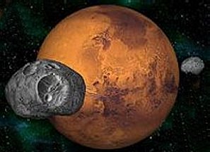
Are Mars and Barsoom the same world?
Or more interestingly, can we find the traces of Barsoom in the Mars we
know?
This has been the subject of a series of essays, I've
titled Matching Mars or the Geographers of Barsoom.
Geographers
of Mars I: Matching Mars and Barsoom, A New Approach -- the first of
these essays, in order, chronicles the history of Primeval Mars, the mighty
impacts that shaped that world, its resulting strangely lopsided geography,
the formation of its mountains and volcanoes and the evidence for oceans
and seas.
 Geographers
of Mars II: The Difficulties of Non-Natural Landmarks -- the second
essay, then proceeds to look at the geography of Burroughs Barsoom, and
begins to match it against the Mars we know, not by trying, initially to
find the living and dead cities. But rather we link discernible geographic
features, like the Toonolian Marshes, the Gathol Seamount, the snow clad
Artolian Hills, the former Gulf of Torquas and the Torquas Mountains, the
Otz Mountains, Valley Dor and Sea of Korus, to documented Martian geographic
features, such as Valles Marinis, Elysium, the Tharsis volcanoes, Hellas
and Argyre.
Geographers
of Mars II: The Difficulties of Non-Natural Landmarks -- the second
essay, then proceeds to look at the geography of Burroughs Barsoom, and
begins to match it against the Mars we know, not by trying, initially to
find the living and dead cities. But rather we link discernible geographic
features, like the Toonolian Marshes, the Gathol Seamount, the snow clad
Artolian Hills, the former Gulf of Torquas and the Torquas Mountains, the
Otz Mountains, Valley Dor and Sea of Korus, to documented Martian geographic
features, such as Valles Marinis, Elysium, the Tharsis volcanoes, Hellas
and Argyre.
This then, should be the third in the series (having written
them completely out of order), which pays particular attention to the polar
regions.
The fourth, and final, has us using the established matches
in geographical features as references to determine or extrapolate the
locations of the living and dead cities of Barsoom.
But why should we pay particular attention to the polar
regions? Because they pose a unique problem.
Unlike say the Toonolian Marshes or Gathol, we do not have to search for
the poles. We know exactly where they are. On the other
hand, Burroughs depictions of the poles show us strange regions, and thus,
we need further explanation to understand why and how Barsoom's poles have
their peculiar features.
So onwards....
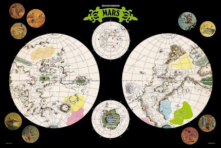
The South Pole - Omean
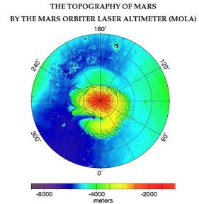
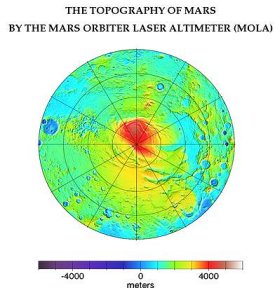 If
we look at either a map of Barsoom's south pole, or a topographical map
of the Martian South Pole, we see a kind of lopsided sort of half moon
bulge. Beneath that bulge is one of the wonders of Barsoom, a buried
sea, called Omean.
If
we look at either a map of Barsoom's south pole, or a topographical map
of the Martian South Pole, we see a kind of lopsided sort of half moon
bulge. Beneath that bulge is one of the wonders of Barsoom, a buried
sea, called Omean.
Oddly enough, this bulge is not too dissimilar from at
least some fan-based maps depicting Omean's outlines at the South pole.
What is this unusual structure and how did it develop?
Omean is tied into the early history of Mars, as we shall see.
Approximately 3.9 billion years ago, Mars had a relatively
small south pole composed mainly of water ice. Then disaster
struck in the form of the Argyre and Hellas impacts in the southern Hemisphere.
Argyre produced a crater 1100 miles wide four miles deep. Hellas
Crater spanned 1400 miles wide and 2500 miles deep.
Both impacts displaced huge quantities of material.
Hellas was surrounded by a thousand mile ring of debris up to a mile high.
The falling debris crossed the northern hemisphere creating the Syrtis
region. It is estimated that the debris raised by Hellas would
have covered an area the size of the continental united states to a depth
of two miles. We can assume that the Argyre impact was only
a little smaller, one half to two thirds the impact. In which case,
we can easily imagine another mile of debris covering the United States.
Of course, in both cases, some of this debris wound up
at the poles, and the planet's orbital mechanics and weather patterns would
concentrate it there. As debris moved up towards the equator, the
planet's turning would cause it to spread and thin. As it moved
towards the pole, the planet's rotation would tend to concentrate it in
a spiral pattern.
And so, Mars ancient south polar ice was covered with
a rain of hot rock from Argyre. The impact of the heated molten
rock on the ice caused massive instant melting, cooling the rock surfaces,
and literally welding them into a granite cap. The South pole
ice cap was covered in thin layer of volatile water beneath a layer of
rock a half mile or mile thick.
This was followed afterwards by the Hellas impact, which
deposited a mile or more of debris. This impact hardened and
condensed the Argyre layer, transforming it into a rigid dome.
Meanwhile, the ice beneath the polar cap began to melt,
transformed by geological heat and the accumulating stress of coriolis
forces. The melted moving water ate away at its rock shell,
dissolving volatiles and lighter elements, including hydrocarbons from
the impact. The soluble materials remained suspended for a
time but eventually chemically reacted and formed a thin limestone shell
all around the sea. The heavier particles eventually sank to
the bottom and congealed in the currents, forming islands and structure.
As a result of water movement within the shell, the upper
shell was eaten away, and the lower floor sank. Thus, as the
volume increased, air emerged in the upper reaches. Trapped
sea's upper levels were filled with gas, mostly hydrogen, oxygen, carbon
dioxides and nitrogen.
Of course, the structure of the buried sea was might well
be unstable, and likely, some sections quite possibly did collapse inward.
Nevertheless, the overall geology had produced a unique arched dome, an
immense hollow structure filled with water. The only comparable
features on earth would be the immense underground reservoirs of oil and
natural gas.
A structural flaw, hydrogen and volatiles eating away
at a pocket, eventually produced a hole, an apparently volcanic appearing
crater, over two miles wide. The pressurized sea erupted out,
in a brief geyser, shaping the crater. The external and
internal atmospheres mixed, and Omen's volatile chemistry stabilized.
The buried sea's level was reduced, though the kilometers deep exit wound
up trapping most of the water vapour. Islands formed or rose
above the surface.
It is likely that this sea was lifeless. During
the period of its formation, there was likely no life on Mars.
Or if there was, it was likely no more complex than bacteria.
If Bacteria did exist, then we could imagine bacterial colonies, strange
arrays of microscopic organisms, living and dying in the bizarre soup of
melted water, hydrocarbon and minerals that formed this sea.
It might even be possible to imagine more complex creatures,
fish or sea slugs, inhabiting this buried ocean, leftovers or developments
of a Mars unspeakably ancient.
But it is more likely that any living species of sea life,
including fish, were probably introduced into this sea by human colonists.
Welcome to Omean, the buried sea, the last sanctuary of
the First Born, and one of the last great bodies of liquid water on the
planet.
The North Pole - Okar
and Pankar
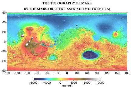
 Look
at the topographic map of the Martian North pole, and we see the polar
cap as a beautiful spiral starfish, trailing a large arm. Look a
little closer, and you can see, fainter, with lower elevation and broader
contours but still recognizably there, a second trailing spiral arm, smaller,
fainter, less well defined but nevertheless present, which makes
the north pole ice cap resemble a swirling spiral galaxy.
Look
at the topographic map of the Martian North pole, and we see the polar
cap as a beautiful spiral starfish, trailing a large arm. Look a
little closer, and you can see, fainter, with lower elevation and broader
contours but still recognizably there, a second trailing spiral arm, smaller,
fainter, less well defined but nevertheless present, which makes
the north pole ice cap resemble a swirling spiral galaxy.
This is the home of two Barsoomian cultures.
Okar, located within the elbow of the large white spiral arm, and Pankar,
hidden within the fold of the lower, broader, smaller and less defined
spiral arm. Near Okar is also the site of the Barsoomian carrion
caves.
To appreciate what this place is, and how it is shaped,
we must turn the page back, and consider again the history of primeval
Mars. Like the rest of the world, the north pole owes its strange
shape to the twin impacts of three to four billion years ago.
The effects of Argyre and Hellas on the North pole were,
in their own ways, nearly as dramatic. The North pole, of course,
received only a fraction of the debris which fell at the south pole.
This arose simply because of distance. The south pole was five
or six times closer to the impact sites than the north pole, and more,
the north pole was well around the curve of the planet.
Nevertheless, the north polar region, like the south polar
region, tended to build up and concentrate its debris. The
rotation which thinned debris out on the equator also thickened it as latitude
increased, and created islands of debris at the pole.
The contribution of Argyre to the north pole was fairly
minimal. The contribution of Hellas somewhat more substantial.
However, unlike the South pole which was buried under miles of welded rock,
the North pole's debris cover was hardly as thick, instead of two miles,
it was perhaps only a few hundred yards.
It was much finer and lighter, because of the distance
travelled, than the heavy rocks which bombarded the south pole, it tended
to include more light volatile chemicals, and the debris tended to concentrate
in spiral patterns, matching the pattern of rotation and further shaped
by coriolis winds.
So, instead of being buried, the north pole continued
as a geographically and geologically distinct region. The ice
cap continued to swell and expand. Now, however, the distribution
of heat absorbing rocks and volatiles guided that expansion and contraction.
The result was the two great spiral arms, representing Hellas and Argyre,
and the overall radiating spiral structure.
The deposited debris mingled with ice, surrounding it
and melting it, while at the same time being shaped by the pressure of
ice above and around. On the Okar arm, melting water beneath
the congealing and solidifying debris sculpted bizarre rocky lands and
formed extensive cavern complexes at the edge of the pole's outer rim.
Leftover sulfides and hydrocarbons gave the caverns their unique smell
and likely fed a strange hothouse ecology, which eventually resulted in
their being named the Carrion Caves.
The Okar arm, as of the vast fall of Hellas debris on
that side, became a territory of impenetrable granite cliffs, surrounded
on both sides by huge towering glacial masses. Within the shelter
of the Okar arm, the landscape became giant valley dozens or hundreds of
miles in length, tapering in towards the pole, with a floor covered by
a mixture of rock, dust, volatiles, ice and snow. It was mineral
rich, stable territory, sufficient to support cities.
According to legend, the fleeing Okar people, retreating
northward, discovered the Carrion Caves and built their cities.
However, the legend is likely not completely accurate.
It seems impossible that a fleeing refugee population, with only the clothes
on their back, could survive in this wasteland long enough to build working
shelters, much less a dome city.
Even if the refugee population was able to find energy
in the buried hydrocarbons, perhaps trapped methane or natural gas, they
should have quickly starved to death. It is more likely that
the Okar region was already discovered, and there was some rudimentary
city or cities and towns already established which could absorb the massive
influx of refugees.
Indeed, the similarities in technology between the Okar
and Pankar domes are suggestive. There's no indication that
these societies have any contact with or knowledge of each other.
Their similar technology could have been independently arrived at, in response
to the harsh conditions. Or they may both have their ultimate
origins in bases established and technologies pioneered during the period
of decline before catastrophic collapse.
The Okar society was completely cut off from the rest
of Barsoom, which is why we place it in the shelter of the high arm, and
the likely heavier debris flow from Hellas.
The debris flow on the opposite side of the pole from
the Argyre and Hellas impacts was much less intense and more diffuse.
The result was a much less distinct spiral ice arm, and a much broader
field. The debris flow also joined fairly continuously
with the surrounding Martian landscape, leading to a gradual transition,
rather than fierce rocky cliffs.
Without the heavy concentration, the shadow or sheltered
area with this spiral ice arm was not cut off and isolated from the rest
of the Martian world. The broad, relatively flat and stable
ice and snow fields around this arm became the perfect storing grounds
for Hin Abtol's army of frozen warriors.
And there we have the strange contours of the north pole
explained, both for Modern Mars, and for Barsoom's cultures.
For those who are imaginative, however, a look at the
Martian north pole shows a couple of other features which might inspire
speculation and wonder. There is a third small inlet into the
pole, just past the great Okar inlet. This one is wider and
less deep, but potentially hides another lost Barsoomian nation.
And if we follow the great Okar inlet further, we see
beyond its end, a small blue dot, an isolated and trapped oasis, surrounded
on all sides by towering cliffs. Is it inhabited?
Of course, we can only take these as tantalizing suggestions
of geography. Burroughs was silent on the matter, leaving us only
with the strange polar civilizations of Okar and Pankar. Let
us be content that we can look at the map of Mars and find them.
Click
for larger image