Official Edgar Rice Burroughs Tribute and Weekly Webzine Site Since 1996 ~ Over 15,000 Web Pages in Archive Presents Volume Zell |
|
Official Edgar Rice Burroughs Tribute and Weekly Webzine Site Since 1996 ~ Over 15,000 Web Pages in Archive Presents Volume Zell |
His love of historical and fantasy cartography may be
seen in his chapter, Paradises Lost, with nine original maps, in Lost
Civilizations & Secrets of the Past (New Page, 2012).
Oberon currently resides in Redmond, WA. He is the primary artist of The Mythic Images Collection (www.themillennialgaia.com/), of which the centerpiece is his revelatory sculpture of Mother Earth as The Millennial Gaia. Books by Oberon Zell: Grimoire for the Apprentice Wizard (New Page, 2004) Companion for the Apprentice Wizard (New Page, 2006) Creating Circles & Ceremonies (with Morning Glory) (New Page, 2006) A Wizards Bestiary (with Ash DeKirk) (New Page, 2007; 2nd ed. 2022) Green Egg Omelette (New Page, 2009) Prophecy & the End of the World (as we know it): Apocalypse or Solartopia? (with Harvey Wasserman) (TheaGenesis, 2012) Barsoom: A New Map of the Mars of Edgar Rice BurroughsJohn Carter of Mars Novels (TheaGenesis 2012) The Wizard and the Witch: An Oral History of Oberon Zell and Morning Glory, by John C. Sulak with Oberon & Morning Glory Zell (Llewellyn, 2014) Death Rights & Rites: A Practical Guide to a Meaningful Death, with Judith Fenley (Llewellyn, 2020) That Undiscoverd Country: A Travelers Guide to the Afterlife (Black Moon Pubs, 2021) Song of Gaea, with Kiri Johnson (a childrens book) Art by Oberon, Sage Lampros, Pratima Sarkar (TheaGenesis, 2021) Goodbye Jesus, Ive Gone Home to Mother (Left Hand Press, 2021) The Wizard and the Witch: Special two-volume expanded edition, by John C. Sulak with Oberon & Morning Glory Zell (Left Hand Press, 2021) GaeaGenesis: Conception and Birth of the Living Earth (Left Hand Press, 2022) Barsoom: Mapping the Mythic Mars, with Steve Warner (TheaGenesis 2022) |
![]()
Long time ERBzine Contributor Oberon Zell is about
to release
a book expanding upon his excellent ERBzine articles
on Barsoom
Oberon has shared a sneak preview chapter for our
readers to enjoy.
The Mapping of Mars
By Oberon Zell, 2022
Like so many Earthlings over the millennia, I have always been fascinated with the Red Planet. Named in ancient times for the God of War (Ares in Greece, Mars in Rome) due to its bloody hue, Mars is the most easily identified among the four brightest planets wandering across the celestial vault.To the ancient Sumerians and Babylonians, Mars was Nergal, the god of war and pestilence. Egyptians called Mars the wandering star. Mars was known as Horus the Red, or the backward traveler. But the people who studied Mars most closely were probably the ancient Mayans:
The Mayan Mars is depicted in ancient engravings as a long-nosed monster or animal, hanging from a band that stretches across the sky. It appears to be descending down to Earth nose-first. In other places, Mars is depicted in what appears to be a regular human form.
But the god Mars wasnt as important to the Mayans as the planet was. Mars the god only appears a few times in Mayan mythology, and his role does not seem to have been a big one. However, the Mayans were able to keep track of Mars peculiar orbit better than anyone else on Earth.
Mars has always baffled ancient astronomers because of its apparent backward motion. Every 25 months or so, it seems to slow down, stop, and start heading the other way. To ancient people, who believed the celestial bodies traveled around the Earth, this was strange. This is one reason why Mars has always fascinated people.
The Mayans were the first to figure out Mars orbit. In the Dresden Codex, they created a Mars calendar that is accurate to the day. They didnt know why Mars traveled backwards, but they knew when it would. The Mayans understood perfectly Mars relationship with the other celestial bodies.
With the invention and improved development of the telescope in the mid-1600s, Mars soon became more than another bright dot in the sky. As with the moon, it revealed features suggestive of the mountains and seas of Earth. Cloud-shrouded Venus was and remains a featureless ball. Cloudy bands could be discerned on Jupiteralong with the great Red Spot. And of course, Saturn had its dramatic rings. But other than the nearby and obviously barren moon, Mars was the only heavenly body with visible topological geography (or properly speaking, areography). And thereforeuniquelya world begging to be mapped.
Starting in the 1860s, with improved telescopes, at each oppositionwhen Mars and Earth are most closely aligneda few dedicated astronomers spent long nights in their observatories peering through the lenses, attempting to discern and draw these features to the best of their ability.
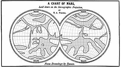
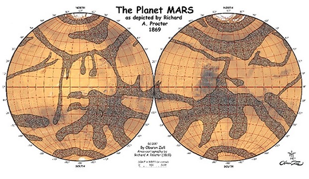
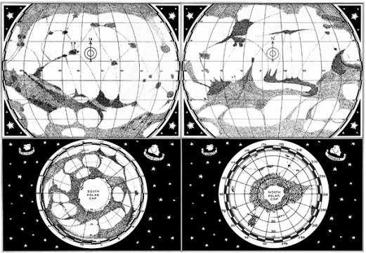
The first decent map of Mars was compiled in 1869 by Richard Proctor. Reproduced here from Proctors Other Worlds Than Ours in 1871, this map was in turn based upon drawings of Mars by the keeneyed observer W.R. Dawes. While Proctor did believe he was seeing evidence for the presence of continents and oceans on the Red Planet, it is notable that he included no canals or canal-like features.
It was the convention of early astronomers to draw maps of Mars with the South at the top, rather than at the bottom, as thats how it looked through their telescopes. So in my effort to give them common reference for comparison, I have rotated them all to show North at the top, as is our current cartographic custom. I have used a Lambert Equal-Area Projection, with latitudes and longitudes spaced at 10° intervals. And for all of these, I used our current designation of the Prime Meridian at a crater named Airy-0 in Sinus Meridiani.
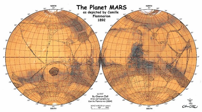
And in as many cases as I deemed suitable, I have overlaid these drawn maps on a modern color image of Mars by the noted National Geographic cartographer Ralph Aeschliman, by which the accuracy of the drawn maps can be ascertained. Here is my color reproduction of R.A. Proctors 1869 map of Mars:
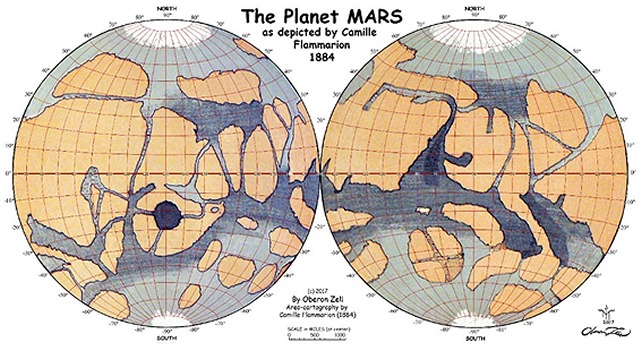
In 1884 Camille Flammarion drew an excellent map of Marsbut with little indication of Schiaparellis famous canali. However, Flammarions 1892 map did indeed include a few such linear features. I reproduce both of those maps here, with my comparative adaptations and overlays as described above.
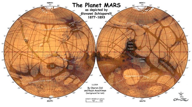
The iconic canals of Mars were first mapped by Giovanni V. Schiaparelli in his Mappa Aerographica (1876, 77, and 79 editions). Each edition became successively more detailed as Schiaparelli continued to fine-tune his drawings from his telescopic observations during Mars oppositions to Earth in the years 1877, 79, 81, 88 and 93. Schiaparellis drawings of the Martian features remained by far the most accurate for a full century. In fact, on his 1879 map Schiaparelli indicated Nix Olympica (now called Olympus Mons), the immense 14-mile high Martian volcano the size of Nevada that no other observer recorded until NASAs Mariner 9 expedition in 1971.
My version here is based on Schiaparellis best and final map of 1893.
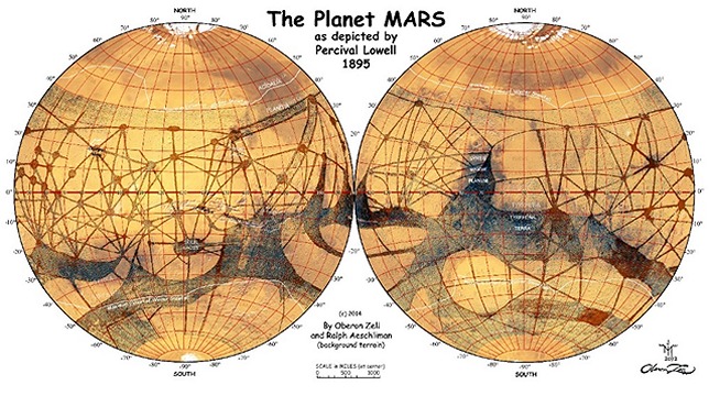
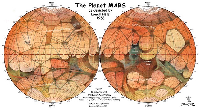
Schiaparellis stunningly detailed maps influenced all subsequent Martian observers and cartographers, who confirmed and replicated his system of Martian canals: Leo Brenner (1894, 96, and 1904); Percival Lowell (1895); Scheiner (1916); Eugene Michel Antoniadi (1930); Gerard de Vaucouleurs (1941); Lowell Hess (1956); E.C. Silpher (1962), and R.A. Wells (1971). Adjusted for projection, the features on Schiaparellis final map of 1893 correlate precisely with our most modern NASA mappingexcept for the canals, for which, sadly, no evidence can be found today.
Schiaparelli called the lines he saw crisscrossing the surface of Mars canali (channels), which was mistranslated in English as canals. A number of prominent scientists, particularly noted astronomer Percival Lowell, theorized that these were immense engineering works constructed by an intelligent race in an attempt to convey diminishing water from the polar regions to irrigate their dying planet.
Percival Lowell (1855-1916) was an American businessman, author, mathematician, and astronomer who fueled speculation that there were canals on Mars, and promoted theories of a 9th planet. In furtherance of his obsession with life on Mars, he founded and funded one of the world's great observatories on a 7,200-foot mountain peak he named Mars Hill, near Flagstaff, Arizona. There he scrutinized the heavens, and particularly Mars, with, his own custom-built 24-inch refracting telescope, built in 1894, which became a marvel of the age. He initiated the effort that 14 years after his death led to the discovery of Pluto.
(In 1930, American astronomer Clyde Tombaugh discovered the dwarf planet using a telescope at the Lowell observatory. When a planetary sigil was being designed for the new body, one proposal was PL for Percival Lowell.)
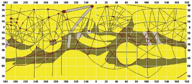
For some fifteen years (1893-1908) Lowell studied Mars extensively, making intricate drawings of the surface markings as he perceived them. In 1895, he produced what I consider to be the worst map of Mars ever drawn. It bears little relation to the actual features of the red Planet, and it is crisscrossed with dozens of random canals with oases that likewise do not even approximate the painstakingly accurate observations of Schiaparelli or Flammarion. Clearly, Lowell just made it all up.
But, as Director of the famed Lowell Observatory, his bogus drawings were creditedin America, at leastover the far more accurate ones of the Italian Schiaparelli and the French Flammarion. Large globes of Lowells version of Mars were produced, which came to define the common perception of Mars among the public.
Here is Lowells original Mercator projection:
And below is my adaptation of Lowells Martian map on the same Lambert Equal-Azimuthal projection I have used for all these maps, overlaid upon Ralph Aeschlimans 1973 National Geographic map of Mars, to which it bears little relation: The single most consistent and prominent feature on all the maps from Camille Flammarions in 1884 is Lacus Solisthe Lake of the SunBurroughs capital city of Helium.
Other prominent features appearing on all maps of the Red Planet are Syrtis Major (Burroughs Kaolian Forest) and Sinus Meridiani..
Lowell published his speculations in three books: Mars (1895), Mars and Its Canals (1906), and Mars as the Abode of Life (1908), thus validating and popularizing the widespread belief that these markings proved the existence of intelligent life and ancient civilization on the Red Planet.
Lowells works include detailed descriptions of what he termed the non-natural features of the planet's surface, including especially a full account of the canals, single and double; the oases, as he termed the dark spots at their intersections; and the varying visibility of both, depending on the Martian seasons. He theorized that an advanced but desperate culture had built the canals to tap Mars' polar ice caps, the last source of water on an inexorably drying planet.
And Lowells writings inspired Edgar Rice Burroughs to write his legendary series of John Carter novels, which took place on the planet Mars (Barsoom) as it was believed to be by the best scientific minds of the time. In particular, Chapter VI: Proofs of Life on Mars, in Mars As the Abode of Life, was clearly the prime inspiration for Burroughs in writing his Barsoom novels. Fortunately, Burroughs drew upon the excellent maps of Schiaparelli rather than those of Lowell for his Barsoomian areography
The War of the Worlds by English author H.G. Wells was written between 1895 and 1897 and serialized in 1897 by Pearsons Magazine in the UK and by Cosmpolitan magazine in the US. One of the earliest stories to recount a conflict between humanity and an invading extraterrestrial race, and predating Burroughs by 14 years, it too was certainly inspired by Lowells first book, Mars.
While the idea of an ancient dying Martian civilization excited the public and provided a setting for many science fiction stories, the astronomical community was skeptical. Although the consensus was that some actual features probably did exist which would account for these markings, many astronomers could not see them, and few believed that they were as extensive as Lowell claimed.
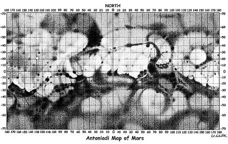
In 1937, astronomer Eugene Antoniadi produced a very different and remarkably accurate map of Mars, with areas of varied shading rather than detailed linesand no canals. As with my other maps in this chapter, I have inverted it to show North at the top.
Antoniadis excellent Mercator map of Mars was reinterpreted and redrawn in intricate precision by Lowell Hess in 1956. It is obvious that Hess also heavily referenced Schiaparelli, whose canali he included:
Certainly the most colorful map ever made of the Red Planet, this one was widely published and even made into a nifty little globe by Reploglenow a rare collectors item.
Given my lifelong obsession with Mars, it should be no surprise that one of my favorite books is The Exploration of Mars, published in 1956 by Willy Ley and Werner von Braun, and profusely illustrated by the legendary Astro-artist Chesley Bonestell. So I would like to conclude this little survey of Martian cartography with Bonestells lovely map from that bookwhich does feature a number of canals. In the north polar view, Bonestell even labels the Martian moons Cluros and Thuriain tribute to Burroughs Barsoom. Unfortunately for our comparison purposes, these maps are drawn with the Prime Meridian at 90°W, splitting the Lacus Solis feature (Burroughs Helium) at that longitude:
For maps of Mars subsequent to this one1940-presentsee previous chapter: The Doom of Barsoom.
References:
1. Dunlap, David W. Life on Mars? You Read It Here First, The New York Times, Oct. 1, 2015.
2. Gallant, Roy A., Exploring Mars. Garden City Books, 1956
3. Guthke, Karl S. The Last Frontier: Imagining Other Worlds from the Copernican Revolution to Modern Fiction. Translated, Helen Atkins. Cornell Univ. Press, 1990.
4. Kidger, Mark, Astronomical Enigmas: Life on Mars, the Star of Bethlehem, and Other Milky Way Mysteries. 2005.
5. Ley, Willy, Von Braun, Werner & Bonestell, Chesley, The Exploration of Mars. Viking Press, NY, 1956.
Milner, Richard, Tracing the Canals of Mars: An Astronomer's Obsession, Space.com, 10/6/2011. www.space.com/13197-mars-canals-water-history-lowell.html
Over one hundred years ago, in 1911, Edgar Rice Burroughs (the creator of Tarzan) introduced an astonished readership to the adventures of John Carter, a Civ-il War soldier from Virginia who, in 1866, found himself trans-ported to the planet Mars. Or, as the natives called it, Barsoom. The first novel was A Princess of Mars, and it was followed by ten more books over the next 30 years; plus countless comic books, and in 2012, a spectacular Disney movie, John Carter. 
AMAZON.COM PURCHASE INFORMATION FOR
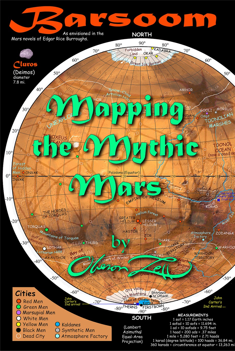
Barsoom: Mapping the Mythic Mars
by Oberon Zell (Author), Steve Warner (Author), Ralph Aeschliman (Contributor)
www.amazon.com/dp/1087953154/Enthralled readers encountered the incomparable Martian Princess Dejah Thoris; four-armed giant Green Men; hideous blue Plant Men; Thoats, Calots, Banths, Apts, White Apes and other multi-legged Martian beasts. Burroughs' Barsoom was a dying world of ancient ruined cities, dry seabeds, desert-spanning canals, towering mountains, polar ice caps, dense forests, and under-ground rivers.
These were the first sci-fi adventure tales ever written that took place on another world, with alien races, civilizations, and creatures-and they pre-ceded and inspired every subsequent extra-planetary adventure series from Flash Gordon to Star Trek and Star Wars.
But despite locating the adventures of John Carter on the canal-covered Mars depicted by Victorian astronomers, Burroughs never provided a map showing the locations of his Barsoomian cities and other features. Over the past century, many fans have tried to compile such a map, but none have truly succeeded. Until now.
Painstakingly referencing clues in all eleven books, plus astronomical observations of the Red Planet spanning a hundred years, noted historian and cartographer Oberon Zell has created the definitive map of Burroughs' Barsoom. This book details that process with three dozen colorful maps and other illustrations, a history of Barsoom over the past million years, and a Gazetteer for all locations mentioned in the novels.
![]()
OBERON'S FEATURES IN ERBzine
![]()
A NEW MAP OF BARSOOM
https://www.erbzine.com/mag39/3937.html
CLUES TO BARSOOMIAN LOCATIONS IN THE CHRONICLES
https://www.erbzine.com/mag39/3938.html
THE FALL OF ANCIENT BARSOOM
(and Some Thoughts on How This Shaped Barsoomian Race
and Culture)
by Steven A. Warner and Oberon Zell
https://www.erbzine.com/mag44/4497.html
THE DOOM OF BARSOOM
https://www.erbzine.com/mag48/4851.html
ANOMALIES IN THE BARSOOM PARADIGM ~ PART I
https://www.erbzine.com/mag51/5110.html
ANOMALIES IN THE BARSOOM PARADIGM ~ PART II
https://www.erbzine.com/mag51/5111.html
ANOMALIES IN THE BARSOOM PARADIGM ~ PART III
https://www.erbzine.com/mag51/5112.html
A VOYAGE TO HORZ I By Steve Warner
https://www.erbzine.com/mag62/6290.html
A VOYAGE TO HORZ II By Steve Warner
https://www.erbzine.com/mag62/6291.html
Grimoire for the Apprentice Wizard (Introduced by Raymond Buckland) (New Page, 2004)
Books by Oberon Zell:
Companion for the Apprentice Wizard (Introduced by Jesse Wolf Hardin) (New Page, 2006)
Creating Circles & Ceremonies (with Morning Glory Zell) (New Page, 2006)
A Wizard's Bestiary (with Ash DeKirk; introduced by Jacques Vallee) (New Page, 2007)
Green Egg Omelette (Introduced by Christopher Penczak & Chas Clifton) (New Page, 2009)
Prophecy and the End of the World (as we know it): Apocalypse or Solartopia? (with Harvey Wasserman) (TheaGenesis, 2012)
Barsoom: A New Map of the Mars of Edgar Rice Burroughs John Carter of Mars Novels (TheaGenesis 2012)