Official Edgar Rice Burroughs Tribute and Weekly Webzine Site
Since 1996 ~ Over 10,000 Web Pages in Archive
Volume 3733
Presents
HELIUM AND THE SURROUNDING REGIONS
By Rick Johnson
Thanks to John Carter, Helium is THE most famous place on Barsoom. At least as far as we who are stuck on Earth know. Yet, we know very little about it. We know it has a forest and iron mines, it has two main cities, each with a mile high tower. We know that it has a modern and very powerful navy. We know that it was a relatively minor nation until after it conquered Zodanga. And not much else.What I am going to do is to take what little we do know and expand upon it by asking myself, how could this be?
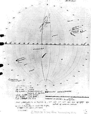
As with all my works, I started off with the Canon material: the maps and descriptions as described by Captain John Carter as told to his nephew, Edgar Rice Burroughs in person or via his diary found after his second death on the Hudson.
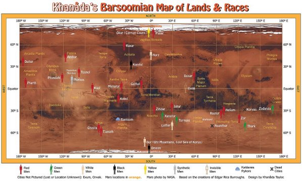
Always I start with the original maps that Burroughs received from Captain Carter in his vault upon the Hudson River. To this are added descriptions given in the books such as: Aaanthor is a dead city between Torquas and Thurd, located at 50 degrees South by 40 degrees East of Horz. And Helium is 30 degrees South of the Equator. Hastor is 500 haads south of Lesser Helium. Once you locate a few cities, a simple rule marked in both statute miles and haads will locate many more cities with but a slight error. And since we know the locations of many cities that were marked on the Burroughs Map, it is quite easy to locate most others.
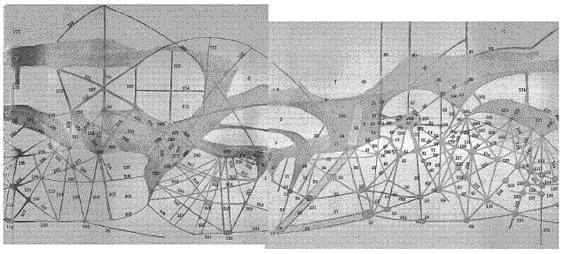
On top of this map I place the Percival Lowell Map as I believe that Burroughs would have been familiar with this map, though it is not reflected in his own notes. Somehow, there is a fit. The Lowell Map shows the darker high desert an the lighter dead seas with the Waterways and many cities. It is not perfect, but then, neither were Captain Carters descriptions of distance and direction.
Consider we in Tucson, Arizona refer to Phoenix as being two hours north of Tucson on Interstate-10. At 75 mph, this places the capital about 150 miles north of Tucson, about the middle of the Hopi Indian Reservation. Yet, Phoenix is closer to 120 miles NW of Tucson. Why the discrepancy? Because when I-10 was built, it left Tucson and headed north before curving NW and as the speed limit at that time was only 65 mph, it became habit to refer to driving north to Phoenix and planning 2 hours for the trip. We know the truth, but custom and habit dictate directions.I suspect that Captain Carter was as casual in his descriptions as are we so west in the books could mean anywhere between NW and SW by the compass! This the dual locations described for Zodanga do not bother me. Both are still generally east of Helium.To this material I added information presented by the great writers and analysts of Barsoom, including (but by no means limited to): Den Valdron, Sildan Cristian, J. Huckenpholer, Fredrik Eckman and many others who have spent their lives reading the works and seeking answers to these questions.
From here I spread out and read the stories of Barsoom written by those who chose to chronicle the Untold Tales of Barsoom (aka Fanfic). I chose to ignore the poorer stories in the fanfic universe, the comics and graphic novels and a few other sources of questionable veracity. I admit that this is somewhat arbitrary but when you want to research Lincoln Isle, you do not watch the 3D film Journey 2: the Mysterious Island starring Dwayne Johnson, you go to the original novel written by Jules Verne which does NOT contain any giant monsters or you read the various papers written by serious scholars who analyzed the novel.
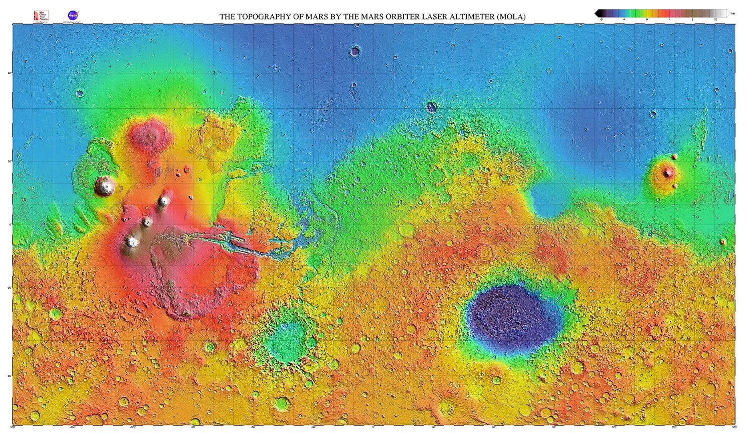
Then I sat down and looked at the result, comparing the maps I created to those taken by the NASA MOLA mappers and I noticed that there was a considerable similarity. It isnt perfect, but then, so few things are. Still, the similarities were close enough to realize that the maps could, to an extent, fit and reveal much.
Once the maps were compared, questions popped into my head. Why are these cities dead but those still alive? Why did the Tharken Territory as shown on the Ballentine Map look the way it does? Why were cities placed in these locations? Questions require answers and often, the answer becomes because the situation requires that. Why are aircraft NOT built like wooden boxes? Because they fly better when they are shaped like a bird. Why are so many major cities on Earth built on major rivers and harbors? Because they need a steady source of drinking water and transportation for trade. Why are there no farms on the top of Mt Everest? Because even the government should realize that you cannot grow corn at 25 thousand feet! Most answers are logical when you step back and take a look. And somehow, when I do that, I find that what I am thinking or seeing DOES match the image presented by Burroughs!
This then, is the result of that pondering.
BOUNDARIES
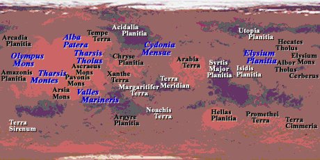
When we look at the quadrant I call the Helium Quadrant, ranging roughly from about 60 degrees south to the equator, from about 60 degrees East to about 170 degrees east, one may ask, Why this area? Because when I glued a series of maps together with Helium roughly in the center, this area gave me a workable area to study. Not too large and not too small.I see the Torques Sea (Hellas Planetia) as being the far western boundary to the Helium Quiadrant and Komad (170E by 27S) as being the far eastern boundry. Torquas is its own area and Komad is the farthest known Heliumite city to the east. 60 south and the equator are convenient boundaries as below 60 degrees South (Helium is at 30 south), there is literally nothing of value save the south polar icecap and north of the Equator, you get into lands owned by other nations.
This area is simply easy to work within and so is mostly an arbitrary choice. This does not mean that Helium controls all the land within these boundaries, I simply chose to call this area the Helium Quadrant as Helium is the largest force within that area. Had I started this a century earlier, Id have centered on Zodanga and called it the Zodanga Quadrant.
MAPPING
As mentioned, the first thing is to take the Burroughs Map and descriptions from the books and chart what I see! Then I add the Lowell Map to find points of reference.
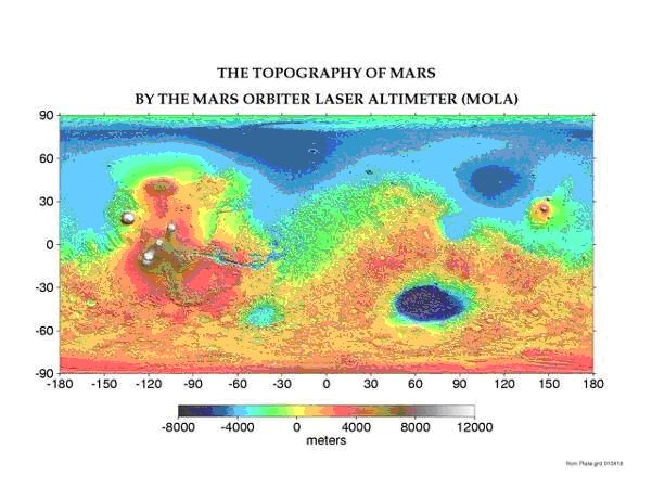
From here I add the MOLA map (adjusted for angle because I suspect a glitch in the NASA download program*) to find details.*When the first pics came in from Mars, they showed a pink sky and red rocks. NASA then told the computer to adjust the colors to show a blue sky which the computer dutifully did, making other similar adjustments as it followed instructions such as showing blue-green dirt and rocks, converting anything with hard and straight lines into a rough rock-like shapes and erasing anything that looked alive. (I was an astronomy student at the time and one of my professors worked on that project so I got info long before it was released to the public. Not to mention the trivia that was dutifully suppressed by NASA for fear it would harm their funding)Then you have that whole laser problem where the results are determined by the time the laser returns to the orbiting satellite.However, the Martian sky IS mostly pink (dust) so all the colors in the photos were wrong until someone got the brilliant idea of telling the computer to adjust the colors to make the American Flag on the lander correct and hang the rest.
IF such a simple assumption can do such damage, imagine what would happen if someone were to tell the computer, erase anything that looks alive because NASA knows that Mars is dead! The Face of Tur now becomes just another block-o-rock and entire cities are converted by the computer to become curious rock formations.
Remember that the Speed of Light is measured in a Zero-Gravity vacuum and slows as it passes through an atmosphere and is deflected by water vapor and atmospheric density. Now, if you believe that the atmosphere on Mars is very thin (about 0.0044 psi) and mostly CO2, then the computer adjusts the speed the laser travels according to those values. BUT, if the atmosphere on Mars is 10 psi (equal to about 2 ½ miles above sea level on Earth) and mostly oxygen, the computers math is off and so are the maps the computer creates.
Also from Captain Carters descriptions, we know that Martian cities use lighting that captures and recycles emitted light, thus any laser from orbit that strikes a city will encounter these lights and thus mess with the NASA Laser to give false readings* and any laser striking this area would be slowed, captured and eventually escape to give a false depth and topography, effectively erasing the city from the created map.
*If any of you have tried to use a GPS in the canyons or mountains or even around tall buildings or power lines, you will understand what this means. The satellite signal bounces off the mountains and building to cause the GPS computer to think that they are in a different part of the sky! And the power lines simply mess with the calculations until you are lucky to be able to tell North to within 30 degrees!Finally, the patterns of the craters revealed from normal photography give a lot of valuable detailed information and, it even fits what Burroughs described. However, not TOO much detail is desired as the map is based on what NASA expects to see and this is what they are telling the computer to record. NASA wants to see a crater-impacted dead world which is what the MOLA Computer gave them. Therefore, a general view is often better than too much details*.*Remember the Blind Sages who sought to describe the elephant, but got too close to the animal and could not see the entire thing? The elephant, dearly beloved, is very much like a snake! The hell it is! The elephant is like a tree trunk!Once I have the general area from the MOLA map, I compare this to the Burroughs Map and look at what I see . Of course making certain assumptions that are based upon the books.Red Men are poor climbers and the atmosphere of Mars is very thin, therefore few Martians would get high enough to see the planet as it is. And as Aviation is only a thousand years old and there are no pressurized cabins in the fleets, any aircraft would be forced to fly very low! Again preventing accurate mapping of the surface.NOTE also that the horizon on Mars is much closer than on Earth. On Earth the distance to the horizon for a 6 man is 3.2 miles or 4.6 km. On Mars it is 2.1 miles or 3.39km Note also that I am saving you the math but there IS a formula that does this math. You just need to adjust the constants for planetary diameter.Note, that even on Earth, it wasnt until satellite imagery appeared that we had any really accurate maps of the Earth. And the Space Age showed us the beautiful blue jewel that is our world, which blew away all previous thoughts of Earth looking like a High School globe!
Any place you stand upon Mars will show the horizon only a couple miles away so the mountains a couple miles away are already sinking below the horizon. Therefore, if you are in a meteoric impact crater more than a few miles across, you will think that you are in a valley simply because much of the crater walls are below the horizon or obscured by dust and so you would not see them as circular.
Strange? Not really. Earth is filled with Impact craters that have eroded away over the millions of years to the point where people no longer recognize them as craters. Look at Hudson Bay in Canada! The Gods must have really hated the Canadian Winters to do that to the place! Note how repeated craters erode into bays and rivers. The same effect exists as on Mars! Or the films of Jupiter when those cometary fragments impacted the surface in a line which was previously thought to be impossible.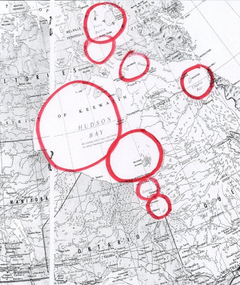
The Hudson chain of asteroid impacts.Thus the Barsoomian word that JC translates as valley is really better trasnsliterated as crater! On Earth, the existence of such impact craters was totally unknown on Earth until very recently. I really doubt that Captain Carter ever saw the Arizona Meteor Crater when he was prospecting the Superstition Mountains some 130 miles south, especially as Daniel Barringer didnt describe the crater as being of extraterrestrial origin until 1902, 40 years after Captain Carter left Earth for Barsoom and even then, it took decades for his claim to be accepted widely as science KNEW that rocks could not fall from the sky! Thus John Carter probably didnt even suspect that the Martian Valleys; were actually impact craters or that such things even existed.
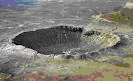
Meteor Crater, ArizonaSo when looking at this, I am thinking that the Valley of Helium is actually an asteroid crater! But which one?
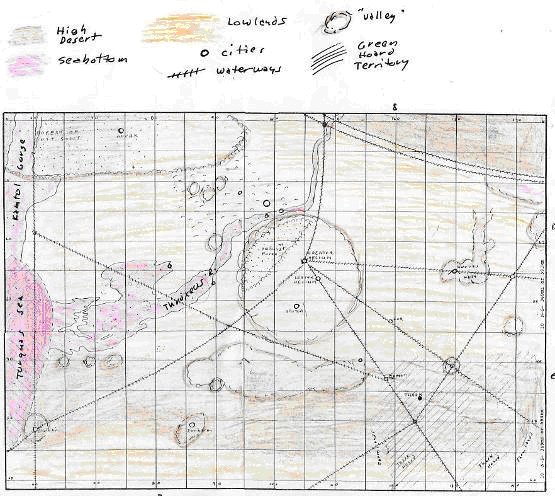
Looking at the MOLA Map, Den Valdron believes that Hellas Planeta is the Torquas Sea basin and I agree with him as his arguments are just too convincing! So as Helium is about 30 degrees south of the equator and east of Torquas, it is simply necessary to find a crater that fits the description.
Kepler Crater is the crater that I believe to be the Valley of Helium! It is so large that the inhabitants dont even realize that they are within a gigantic impact crater as the walls are over the horizon yet the stony-iron core of the meteor that made the valley continues to supply Helium with the iron it needs to remain a world-power. The crater rim would provide a moisture trap to capture moist air to water the Helium Forest and the walls would keep the people isolated and protected so they would be bypassed by Zodanga which was one of the great Super-powers of Barsoom. It is this place where I start my examination.
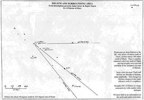
The Dejah Thoris map that was scratched into the floor of that long-dead city for Captain Carter to plan their escape from the Tharks reveals a number of interesting things. There are three described waterways extending from Helium towards the SouthEast. One goes east to an unnamed city, the other two SW through Lesser Helium, Zor and bypassing Thark. Some cities are friendsly to Helium, some not. But, why does that waterway bypass Thark?
Well, people need water to survive and if Thark had a waterway touching it, it wouldnt be dead would it? Therefore any city that is ON a waterway must remain thriving and those away from a waterway are dead or barely alive, relying on deep wells for survival. Thark is dead so it cannot be on or even close to a waterway and this is born out by the descriptions in Princess of Mars. I suspect that it was a great city but was abandoned early in the Construction of the Waterways and so was bypassed.
Looking east from Kepler I see the triple Higgins crater system with a mound in the center. Is this Korvas described in the literature? It would make sense as these three interconnected craters with a single mount in the western one would be iron rich and provide protection from the Green Hoards. The waterway that passes through Korvas would easily irrigate the entirety of the three craters to feed a large city.
Continuing east we find Rossby crater and then Copernicus. Im thinking that the waterway that heads east from Helium passes through Higgins/Korvas and ends at Rossby/Komad because once past Komad there is nothing but the Warhoon hoard and the Great Desert until you circle the planet to reach Torquas! SE of Komad is the Atmosphere plant and there are so many possibilities for the exact location of this vital building that I will lave it to people far better than am I to locate this structure.
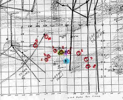
From A. Q. Porter on the location of the Atmosphere plant:
#1- Joe Ferrier shows it at 44º S., 152º W.
#2- Tracy Griffin puts it near 40º S., 154º E.
#3- Frank Brueckel's map shows it at 32ºS., 165º E.
#4- On Mike Resnick's map it's at 34º S., 172º E.
#5- Heins puts it at 34º S., 175º W.
#6- I had it at 38º S., 162º W. on my 1967 map.
#7- Both of John Roy's maps show it at about 44º S., 152º W.
#8- The map from the "John Carter of Mars" board game shows it at 56º S., 150 W.
#9- Larry Ivie places it at 23º S., 138º E.
#10- Robert H. Schlutter's 1949 map places it at approximately 11º S., 152º E.Between Korvas and Komad would be another waterway that leads to Zodanga! And following this line we see a great lowland area that would be less barren than the high desert. What better place to build a great empire? This low area west of the Serenum Fossae is Zodanga! It is large and low and so would grow thick moss for thoats and crops, both of which are vital to the survival of the Red Man!
I see that if I follow the line SSW from Zodanga and SE from Helium, I reach Mendel crater, an unnamed city within Tharkan territory I imagine that these people would have a mighty army to survive there and were probably subject to Zodanga whose empire stretched from the ice-clad north to the ice-clad south. This, then, would be one of the unfriendly cities Dejah Thoris described to John Carter. I also see two lowlands to the east and west which would be the fertile regions described by Dejah Thoris that border the territory of the Tharks! Lowlands would be the bottoms of lakes and seas where silt would settle and be fertile as the water is trapped in those regions. In other words, excellent farmlands.
There isnt much mentioned to the south or southwest in any of the literature, though I do place a few fanfic cities in this area based on the descriptions mentioned in the stories. So, moving to the NW, we see a chain of connected craters that merge into a lowland that moves from Hellas east to Kepler which it avoids to move north and east then north again to avoid the crater rim of Kepler until it reaches the large lowlands in the north which I believe to be Throxeus. If Hellas was one of the Five Seas of Ancient Barsoom, this series of interconnected craters and lowlands would be a large bay and river that allows the Torquas Sea to flow into Throxeus which I call the Throxeus River only because I have named the north-flowing river the Kamtol Gorge/River.
Around this river you will see a few cities. There are some highlands that stretch from this river NW to the lowlands of the northern area of the Prometheus Terra which I believe to be the Forest of Lost Souls. There are a few cities in these highlands and two in the bottom of the river. I suspect that the ones in the highlands are the original cities which were abandoned to build newer cities in the silt-rich bed of the Throxeus River as this river dried up.
CONCLUSION
What I am seeing here is a series of interconnected and occasionally isolated impact craters that the Martians would see as valleys and mountains. Some that connected as in Hudson Bay, would allow the ancient rivers to flow from Sea to Sea, others would provide rich sources of iron to fuel industry, still others would be low enough to retain moisture to grow thick moss.As we follow the underground Waterways of Barsoom (canali to the early astronomers), we see that they often pass through a crater that would easily support a city mentioned by Burroughs and thus the Builders would cut into that crater to feed water to such a city. Moss-rich lowlands, iron rich craters, cities along then within rivers and seas, perhaps Higgins was a lake that dried to a marsh then to simply moss-fields. If the Helium Forest is at the NW of the Valley of Helium, it would explain a lot as the Throxeus River would have irrigated that area of Kepler by super-saturating the ground in that area as it was diverted by the crater walls. Perhaps there is still underground water leeching up through the rocks to keep the forest alive or pipes that were bored through the crater wall to the river? The two lowlands that border the territory of the Tharks would be fertile and well protected and so limit Tharken expansion in those areas, forcing them to raid north and south, thus encouraging Zodanga to military might.
Thus, once again, when we analyze the writings of Burroughs, we see how easily they fit into modern imagery. Obviously, Burroughs knew more than he was letting on or is NASA simply mapping what John Carter discovered so long ago.

BILL
HILLMAN: Editor and Webmaster
BILL
AND SUE-ON HILLMAN ECLECTIC STUDIO
ERB
Text, ERB Images and Tarzan® are ©Edgar Rice Burroughs, Inc.-
All Rights Reserved.
All
Original Work ©1996-2012 by Bill Hillman and/or Contributing Authors/Owners
No
part of this web site may be reproduced without permission from the respective
owners.