article
Ive been a fan of all Burroughs work since I was a kid growing up
in the 1940s-50s. I absolutely love the new John Carter movieI only wish
they had titled it A Princess of Mars, which Im sure would have attracted
a greater audience than the title John Carter, which clearly didnt mean
anything to non-fans. But I thought that Disney did as good a job on this
one as they did so long ago with 20,000 Leagues. Im really bummed that
it got such an undeserved poor public reception, as I want to see the sequels,
and now it looks they may not make any.
Anyway, the movie prompted me to go back and read all the books againand
also to compare them with the various comic books versions outespecially
the really fabulous Warlord of Mars series from Dynamite that is doing
the books page-by-page with fantastic art.
In the process of all this Ive taken a great interest in the mapping
aspect. Im a cartographer, very inspired by Tolkeins style, and I recently
did a series of maps of ancient archaeological sites for a book called
Lost Civilizations & Secrets of the Past (New Page Books, 2012).
See attached examples.
I would love to do some really nice Areographic maps of Barsoom in my
own Tolkein-inspired style, based on those wonderful old pre-Viking maps
with the canals and all that certainly inspired Burroughs, combined with
the accurate images we now have. But I cant seem to find any consistency
in the locations of the various cities, etc. on the various maps you currently
have on the ERB site. This is frustrating, and I would love some direction
as to how to resolve these totally different interpretations. I will have
to study your Atlas of Barsoom carefully to see what clues can be assembled
from the various references in the books
Also, some of the maps you have look promising, but theyre all in 72
dpi low-resolution, and I cannot make out the names of the various locales.
Is there a way I could get hold of higher-resolution copies?
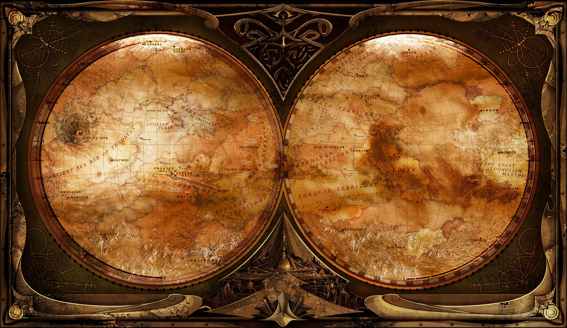
Meanwhile, I just spent a few days creating a two-hemisphere image of
Barsoom which fuses the modern photography with the Antoniadi-inspired
globe. (See attached) I think its pretty neatexactly what Burroughs would
have loved (and what should have been shown in the movie). And you are
certainly welcome to display it on your site if you wish.
So now I just need reliable info on the latitude and longitude of all
those places
Never Thirst,
Oberon Zell

Meanwhile, heres what Ive been working on. I havent seen any map
of Barsoom that really satisfies me, so I figgered Id have to do it myself.
First I had to find a perfect stereographic two-hemisphere image of the
planet Mars as we know it from NASA surveys. Then I drew up several matching
grids, at 10° and 15° intervals. Then I went through all the many
versions of old maps of Mars with the canals from Shiaparelli to Lowell,
and created a reasonable synthesis which I then drew from scratch on my
10° stereographic grid (since most of the old ones were Mercator Projection,
which I really dont like because of the distortion).
Burroughs, of course, had no access to our modern images of the red
planet, so of course his Barsoom was based on the maps by Shiaparelli,
Aldrovani, Lowell, etc. with all the canals. He even mentions these as
waterways connecting the cities of Barsoom. So any map of Barsoom has
to be laid out against those Victorian-era maps, not against modern NASA
photos. This is a place where most modern Barsoomian cartographers seem
to have missed the point.
(BTW, I noticed that some of the previous attempted maps of Barsoom
were drawn on inverted old maps of Marsit was the custom of Victorian
astronomers to draw maps of Mars with the South at the top, rather than
at the bottom, as thats how it looked through their telescopes. Since
Viking, all modern maps of Mars are of course drawn with North at the top,
but I can see that many previous Barsoomian cartographers were confused
by this convention
)
Anyway, I then merged the modern stereographic image with my matching
map of the canals, overlaid them with my 15° grid (more aesthetic
than the 10° one I used for drawing purposes), marked out a scale of
miles, and started studying where the cities would have to go. The first
one to place, of course, had to be the twin cities of Helium. Here I took
a clue from Burroughs, who says that Carter routinely translated Barsoomian
terms into English. Helium comes from the Greek name of the Sun god, Helios.
And prominent on all those Victorian maps is a major feature they called
The Lake of the Sun, or Solis Lacus. With several major canals leading
into it, this had to be where Burroughs would have located him city of
Helium. And indeed, the latitude of 25° matches the latitude of Helium
as drawn on Burroughs rather crude and simple map.
From that point it was a staightforwared matter of matching locations
of Barsoomian cities with major intersections of canals, stsarting with
Zodanga. They seem to fit quite nicely. And the city of Kaol, which Burroughs
located right on the equator, in the middle of a huge forest, nearly halfway
around the planet from Helium fits right in the middle of the major equatorial
dark feature we call Syrtis Majorwhich looks just like a forest.
Then of course there was the River Iss, which is pretty hard to locate
on any of those old maps. Fortunately, weve discovered a perfect Martian
feature in the Valles Marinusthe 3,000-mile long canyon. Using that as
a starting point, and a modern elevation map of Mars, I was able to snake
the river through the canyon and through the lowest points and crevices
all the way to the South Pole.
So now Im sending you my mapping project to date. All it really needs
is to pinpoint all the cities and write in their names. Ive made a start
on some likely locations, but all the maps Ive seen are very contradictory
in their locations of cities. So Im hoping you might be able to help me
at this pointor else put me in touch with Henry Hardy Heines or someone
equally knowledgable who can. The final result will be an absolutely definitive
map of Barsoom which will print out to 11x17.
Never Thirst,
Oberon
From: ERBzine [mailto:erbzine@westman.wave.ca]
Sent: Wednesday, April 11, 2012 12:38 AM
To: Oberon Zell
Subject: Re: New art of Barsoom
Will work on this when I get home, Oberon.
Bill
www.hillmanweb.com
----- Original Message -----
From: Oberon Zell
To: 'ERBzine'
Sent: Wednesday, April 11, 2012 2:24 AM
Subject: RE: New art of Barsoom
Thanks, Bill!
Attached are the maps from your site that Id love to get in higher
resolution--I converted them to 300 dpi, but it still wasnt good enough.
So if you can scan any of these for me at 300 dpi, that would be great!
My plan is to create a perfect fusion of the Shiaparelli-Antoniadi-Flammarion-Bonestell-British
Astronomical Assn. maps, overlay these on a background of matching territory
from NASA, and create a two-hemisphere map on the same grided projection
that Burroughs used (as well as Roy & Campbell), with all the Barsoom
locales marked appropriately. An ambitious project, but it should be pretty
cool when its done.
Right now Im gathering reference maps, as Ill have to hand-draw this
from scratch
NT-OZ
From: ERBzine [mailto:erbzine@westman.wave.ca]
Sent: Tuesday, April 10, 2012 10:01 PM
To: Oberon Zell
Subject: Re: New art of Barsoom
Oberon:
I agree with your comments on the JC film.
. . . and really hope you pursue your Barsoom map project.
Many of the maps on my site were designed for Web display which normally is of low res 72.
However, I do have print copies of some of the maps which I could rescan in highers.
I'll have to put this on hold for a few weeks since I'm currently in Louisiana for a Tarzan Festival . . . a long way from my Brandon library : )
Please stay in touch and keep me informed on your progress with this.
Bill Hillman
www.ERBzine.com
----- Original Message -----
From: Oberon Zell
To: ERBzine@westman.wave.ca
Sent: Tuesday, April 10, 2012 8:16 PM
Subject: New art of Barsoom
Dear Bill,
Kaor!
Ive been a fan of all Burroughs work since I was a kid growing up
in the 1940s-50s. I absolutely love the new John Carter movieI only wish
they had titled it A Princess of Mars, which Im sure would have attracted
a greater audience than the title John Carter, which clearly didnt mean
anything to non-fans. But I thought that Disney did as good a job on this
one as they did so long ago with 20,000 Leagues. Im really bummed that
it got such an undeserved poor public reception, as I want to see the sequels,
and now it looks they may not make any.
Anyway, the movie prompted me to go back and read all the books againand
also to compare them with the various comic books versions outespecially
the really fabulous Warlord of Mars series from Dynamite that is doing
the books page-by-page with fantastic art.
In the process of all this Ive taken a great interest in the mapping
aspect. Im a cartographer, very inspired by Tolkeins style, and I recently
did a series of maps of ancient archaeological sites for a book called
Lost Civilizations & Secrets of the Past (New Page Books, 2012).
See attached examples.
I would love to do some really nice Areographic maps of Barsoom in my
own Tolkein-inspired style, based on those wonderful old pre-Viking maps
with the canals and all that certainly inspired Burroughs, combined with
the accurate images we now have. But I cant seem to find any consistency
in the locations of the various cities, etc. on the various maps you currently
have on the ERB site. This is frustrating, and I would love some direction
as to how to resolve these totally different interpretations. I will have
to study your Atlas of Barsoom carefully to see what clues can be assembled
from the various references in the books
Also, some of the maps you have look promising, but theyre all in 72
dpi low-resolution, and I cannot make out the names of the various locales.
Is there a way I could get hold of higher-resolution copies?
Meanwhile, I just spent a few days creating a two-hemisphere image of
Barsoom which fuses the modern photography with the Antoniadi-inspired
globe. (See attached) I think its pretty neatexactly what Burroughs would
have loved (and what should have been shown in the movie). And you are
certainly welcome to display it on your site if you wish.
So now I just need reliable info on the latitude and longitude of all
those places
Never Thirst,
Oberon Zell

